geo.wikisort.org - Island
Paulet Island is a circular island about 1.5 km (0.93 mi) in diameter, lying 4.5 km (2.8 mi) south-east of Dundee Island, off the north-eastern end of the Antarctic Peninsula. Because of its large penguin colony, it is a popular destination for sightseeing tours.
 Map of Graham Land, showing Paulet Island (10) | |
 Paulet Island Location in Antarctica | |
| Geography | |
|---|---|
| Location | Antarctica |
| Coordinates | 63°35′S 55°47′W |
| Archipelago | Joinville Island group |
| Length | 1.5 km (0.93 mi) |
| Width | 1.5 km (0.93 mi) |
| Administration | |
| Administered under the Antarctic Treaty System | |
| Demographics | |
| Population | Uninhabited |
| Paulet Island | |
|---|---|
 Paulet Island, December 2004 | |
| Highest point | |
| Elevation | 353 m (1,158 ft)[1] |
| Prominence | 353 m (1,158 ft) |
| Coordinates | 63°35′S 55°47′W[1] |
| Geography | |
| Location | Antarctic Peninsula, Antarctica |
| Geology | |
| Mountain type | Cinder cone[1] |
| Last eruption | Unknown |
Description
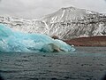
The island is composed of lava flows capped by a cinder cone with a small summit crater. Geothermal heat keeps parts of the island ice-free, and the youthful morphology of the volcano suggests that it was last active within the last 1,000 years.[1] The island is part of the James Ross Island Volcanic Group.[2]
Historic monuments
Paulet Island was discovered by a British expedition (1839–1843) under James Clark Ross and named by him for Captain the Right Honorable Lord George Paulet, Royal Navy.
In 1903 during the Swedish Antarctic Expedition led by Otto Nordenskiöld his ship Antarctic was crushed and sunk by the ice off the coast of the island. A stone hut built in February 1903 by shipwreck survivors, together with the grave of an expedition member, and the cairn built on the highest point of the island to draw the attention of rescuers, have been designated a Historic Site or Monument (HSM 41), following a proposal by Argentina and the United Kingdom to the Antarctic Treaty Consultative Meeting.[3] The shipwrecked crew of the Endurance original plan was to travel to the island and use stores there that were left by the above Swedish Expedition but the ice pack that they were stranded on eventually drifted too far east.[4]
Important Bird Area
The island has been identified as an Important Bird Area (IBA) by BirdLife International because it supports a very large breeding colony of about 100,000 pairs of Adélie penguins. Other birds known to nest on the island include imperial shags, snow petrels and kelp gulls.[5]

Gallery
 Paulet Island (February 2007)
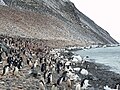 Adelie penguin colony on Paulet Island
 Paulet Island (December 2021)


See also
References
- "Paulet". Global Volcanism Program. Smithsonian Institution.
- "Geological Map of James Ross Island" (PDF). Retrieved 23 March 2020.
- "List of Historic Sites and Monuments approved by the ATCM (2012)" (PDF). Antarctic Treaty Secretariat. 2012. Retrieved 31 December 2013.
- Armstrong, Jennifer (1998). Shipwreck at the Bottom of the World. Knopf a imprint of Random House Children's Books, a division of Random House LLC, a Penguin Random House Company.
- "Paulet Island". BirdLife data zone: Important Bird Areas. BirdLife International. 2013. Retrieved 12 January 2013.
Bibliography
- Antarctica. Sydney: Reader's Digest, 1985, pp. 152–159.
- Child, Jack. Antarctica and South American Geopolitics: Frozen Lebensraum. New York: Praeger Publishers, 1988, pp. 69, 72.
- Lonely Planet, Antarctica: a Lonely Planet Travel Survival Kit, Oakland, CA: Lonely Planet Publications, 1996, 302.
- Stewart, Andrew, Antarctica: An Encyclopedia. London: McFarland and Co., 1990 (2 volumes), p 752.
- U.S. National Science Foundation, Geographic Names of the Antarctic, Fred G. Alberts, ed. Washington: NSF, 1980.
- LeMasurier, W. E.; Thomson, J. W., eds. (1990). Volcanoes of the Antarctic Plate and Southern Oceans. American Geophysical Union. p. 512 pp. ISBN 0-87590-172-7.
External links
- More information about Paulet Island
- Picture of Paulet Island with thousands of Antarctic Penguins
- Another picture of Paulet Island
- Comprehensive Report about Paulet Island with a lot of pictures
На других языках
[de] Paulet-Insel
Die Paulet-Insel (englisch Paulet Island, französisch Île Paulet, schwedisch Pauletön) ist eine kleine, beinahe kreisrunde unbewohnte Vulkaninsel an der Spitze der Antarktischen Halbinsel im südpolaren Weddell-Meer.- [en] Paulet Island
[es] Isla Paulet
La isla Paulet es una isla de la Antártida en el archipiélago de Joinville, situada a a 3 millas al sudeste de la isla Dundee, en el extremo noreste de la península Antártica.[fr] Île Paulet
L'île Paulet est une île circulaire d'environ 4,0 km de diamètre et située à environ 2,5 km au sud est de l'île Dundee, au large de la côté nord est de la péninsule Antarctique.[it] Isola Paulet
L'isola Paulet (in inglese Paulet Island) è un'isola antartica facente parte della terra Graham (penisola Antartica).[ru] Паулет (остров)
Паулет — вулканический остров в Антарктике. Остров был открыт британской экспедицией 1839—1843 годов. Шлаковый вулкан, высотой 353 метра, находится в 4,5 километрах к юго-востоку от острова Данди, у северо-восточной оконечности Антарктического полуострова.Другой контент может иметь иную лицензию. Перед использованием материалов сайта WikiSort.org внимательно изучите правила лицензирования конкретных элементов наполнения сайта.
WikiSort.org - проект по пересортировке и дополнению контента Википедии