geo.wikisort.org - Island
Stonington Island is a rocky island lying 1.8 km (1.1 mi) northeast of Neny Island in the eastern part of Marguerite Bay off the west coast of Graham Land, Antarctica. It is 0.75 km (0.47 mi) long from north-west to south-east and 0.37 km (0.23 mi) wide, yielding an area of 20 ha (49 acres). It was formerly connected by a drifted snow slope to Northeast Glacier on the mainland. Highest elevation is Anemometer Hill which rises to 25 m (82 ft).
History
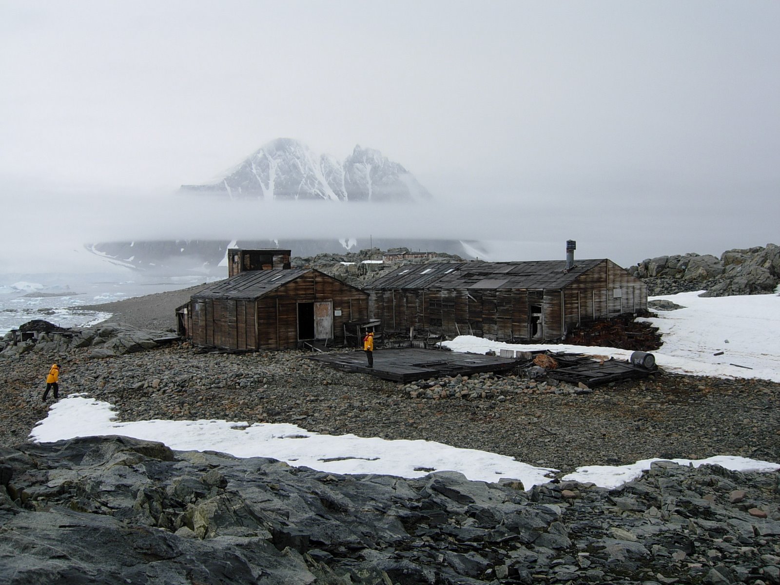
Stonington Island was chosen as the site for the East Base of the United States Antarctic Service (USAS) Expedition (1939–41). It was named after Stonington, Connecticut, home port of the sloop Hero in which Captain Nathaniel Palmer sighted the Antarctic continent in 1820.[1]
Station E

The island was also home to the British Antarctic Survey (BAS) Station E[2] and the Ronne Antarctic Research Expedition, and was the base of operations for many historic Antarctic Peninsula surveying missions in the 1940s. Station E was occupied until 23 February 1975 and the main building was known as Trepassey House, it was cleaned up and repaired in 1992.[3] The huts are protected under the Antarctic Treaty.[4]
Historic sites
A protected area on the island consists of the buildings and artifacts at East Base (with their immediate environs) that were erected and used during the two US wintering expeditions. The size of the area is about 1,100 yards (1,000 m)north-south, from the beach to Northeast Glacier adjacent to Back Bay, and 550 yards (500 m) east-west. It has been designated a Historic Site or Monument (HSM 55) following a proposal by the US to the Antarctic Treaty Consultative Meeting (ATCM). The British Station E research station is also considered to be of historical importance in relating to both the early period of exploration and the later BAS history of the 1960s and 1970s, and it has been similarly designated a Historic Site or Monument (HSM 64) following a proposal by the United Kingdom to the ATCM.[5]
Environment
Climate
Important Bird Area
A circular, 500 ha site on the island has been designated an Important Bird Area (IBA) by BirdLife International because it supports a breeding colony of about 135 pairs of imperial shags. Other birds breeding at the site include south polar skuas and Antarctic terns.[6]
Features
- Anemometer Hill, northeast of Fishtrap Cove on Stonington Island
- Gull Channel, between Dynamite Island and Stonington Island
- Haulaway Point, midway along the northeast side of Stonington Island
- Mast Hill, about 100 meters from the western end of Stonington Island
- Tragic Corner, a bluff marking the northeast end of Boulding Ridge
See also
- Crime in Antarctica
- Edith Ronne
- List of Antarctic and subantarctic islands
- List of Antarctic field camps
- List of Antarctic research stations
References
- Parfit, Michael; Robb Kendrick (March 1993). "Reclaiming a Lost Antarctic Base". National Geographic. 183 (3): 110–126.
- Station E British Antarctic Survey
- "Stonington Island - Antarctic Historic Site and Monument". British Antarctic Survey, Natural Environmental Research Council. Retrieved 31 May 2009.
- Stonehouse, Bernard (2002). Encyclopedia of Antarctica and the Southern Oceans. John Wiley and Sons. ISBN 0-471-98665-8.
- "List of Historic Sites and Monuments approved by the ATCM (2012)" (PDF). Antarctic Treaty Secretariat. 2012. Retrieved 3 January 2014.
- "Stonington Island". BirdLife data zone: Important Bird Areas. BirdLife International. 2013. Retrieved 20 January 2013.
External links
Antarctica | ||||||||
|---|---|---|---|---|---|---|---|---|
| Geography |
|  | ||||||
| History |
| |||||||
| Politics |
| |||||||
| Society |
| |||||||
| Famous explorers |
| |||||||
| ||||||||
| Authority control |
|---|
На других языках
[de] Stonington-Insel
Die Stonington-Insel ist eine felsige Insel, die 1,5 km nordöstlich der Neny-Insel im östlichen Abschnitt der Marguerite Bay vor der Fallières-Küste des Grahamlands auf der Antarktischen Halbinsel liegt. Sie ist etwa 650 × 320 m groß und war bis in die 1970er-Jahre über eine Schneebrücke mit dem Northeast-Gletscher am Festland verbunden. An gleicher Stelle sind jetzt 400 Meter offenes Meer bis zur Abbruchkante des Gletschers.- [en] Stonington Island
[es] Isla Stonington
La isla Stonington es una isla rocosa a 1 milla al noreste de la isla Neny en la parte este de la bahía Margarita en la costa occidental de la Tierra de Graham en la Antártida.[fr] Île Stonington
L'île Stonington est une île située au nord-est de l'île Neny, dans l'est de la baie de Marguerite, dans l'ouest de la Terre de Graham, en Antarctique.[ru] Стонингтон (остров)
Стонингтон — скалистый остров, лежащий в 1,8 км к северо-востоку от острова Нены в восточной части Маргерит-Бей у западного побережья Земли Грейама, Антарктида. Длина острова 0,75 км с севера-запада на юго-восток, ширина 0,37 км, площадь 20 гектаров. Наибольшая высота 25 метров. Ранее соединялся снежным склоном к северо-восточному леднику на материке.Другой контент может иметь иную лицензию. Перед использованием материалов сайта WikiSort.org внимательно изучите правила лицензирования конкретных элементов наполнения сайта.
WikiSort.org - проект по пересортировке и дополнению контента Википедии