geo.wikisort.org - Coast
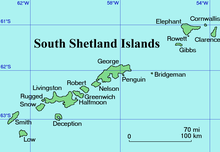
Cape Bowles is a cape forming the southern extremity of Clarence Island in the South Shetland Islands of Antarctica. It was named in 1820 by Edward Bransfield, Master, Royal Navy, while exploring the islands in the brig Williams.

Important Bird Area
The site has been identified as an Important Bird Area (IBA) by BirdLife International because it supports a very large breeding colony of over 100,000 pairs of chinstrap penguins.[1]
References
- "Cape Bowles, Clarence Island". BirdLife data zone: Important Bird Areas. BirdLife International. 2012. Archived from the original on 2007-07-10. Retrieved 2012-12-10.
 This article incorporates public domain material from the United States Geological Survey document: "Bowles, Cape". (content from the Geographic Names Information System)
This Clarence Island (South Shetland Islands) location article is a stub. You can help Wikipedia by expanding it. |
На других языках
[de] Kap Bowles
Kap Bowles ist das Südkap von Clarence Island im Archipel der Südlichen Shetlandinseln. Es markiert die Ostseite der Thunder Bay.- [en] Cape Bowles
Текст в блоке "Читать" взят с сайта "Википедия" и доступен по лицензии Creative Commons Attribution-ShareAlike; в отдельных случаях могут действовать дополнительные условия.
Другой контент может иметь иную лицензию. Перед использованием материалов сайта WikiSort.org внимательно изучите правила лицензирования конкретных элементов наполнения сайта.
Другой контент может иметь иную лицензию. Перед использованием материалов сайта WikiSort.org внимательно изучите правила лицензирования конкретных элементов наполнения сайта.
2019-2026
WikiSort.org - проект по пересортировке и дополнению контента Википедии
WikiSort.org - проект по пересортировке и дополнению контента Википедии