geo.wikisort.org - Mountains
Duclos-Guyot Bluff (Bulgarian: връх Дюкло Гийо, ‘Vrah Duclos-Guyot’ \'vrah dyu-'klo gi-'yo\) is the ice-covered peak rising to 1800 m at the south extremity of Urda Ridge on Clarence Island in the South Shetland Islands, Antarctica. It has precipitous and partly ice-free south slopes, and surmounts Skaplizo Glacier to the west and Dobrodan Glacier to the northeast.

The peak is named after the French mariner Nicolas Pierre Duclos-Guyot (1722-1794), second in command under Louis Antoine de Bougainville in the first French circumnavigation of the world, who sailed in Antarctic waters on board the Spanish ship León in 1756.
Location
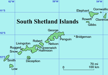
Duclos-Guyot Bluff is located at 61°17′58″S 54°07′28″W, which is 2.9 km northwest of Cape Bowles, 5.6 km east of Craggy Point and 2.4 km south of Mount Irving. British mapping in 1972 and 2009.
Maps
- British Antarctic Territory. Scale 1:200000 topographic map. DOS 610 Series, Sheet W 61 54. Directorate of Overseas Surveys, Tolworth, UK, 1972.
- South Shetland Islands: Elephant, Clarence and Gibbs Islands. Scale 1:220000 topographic map. UK Antarctic Place-names Committee, 2009.
- Antarctic Digital Database (ADD). Scale 1:250000 topographic map of Antarctica. Scientific Committee on Antarctic Research (SCAR). Since 1993, regularly upgraded and updated.
References
- Bulgarian Antarctic Gazetteer. Antarctic Place-names Commission. (details in Bulgarian, basic data in English)
- Duclos-Guyot Bluff. SCAR Composite Gazetteer of Antarctica.
External links
- Duclos-Guyot Bluff. Copernix satellite image
This article includes information from the Antarctic Place-names Commission of Bulgaria which is used with permission.
This Clarence Island (South Shetland Islands) location article is a stub. You can help Wikipedia by expanding it. |
На других языках
[de] Duclos-Guyot Bluff
Das Duclos-Guyot Bluff (englisch; bulgarisch Връх Дюкло Гийо .mw-parser-output .Latn{font-family:"Akzidenz Grotesk","Arial","Avant Garde Gothic","Calibri","Futura","Geneva","Gill Sans","Helvetica","Lucida Grande","Lucida Sans Unicode","Lucida Grande","Stone Sans","Tahoma","Trebuchet","Univers","Verdana"}Wrach Djuklo Gijo) ist ein 1800 m hoher und vereister Berg auf Clarence Island im Archipel der Südlichen Shetlandinseln. Er ragt 2,9 km nordwestlich des Kap Bowles, 5,6 km östlich des Craggy Point und 2,4 km südlich des Mount Irving am südlichen Ende des Urda Ridge auf. Seine markanten Südhänge sind teilweise unvereist. Der Skapliso-Gletscher liegt westlich und der Dobrodan-Gletscher nordöstlich von ihm.- [en] Duclos-Guyot Bluff
Другой контент может иметь иную лицензию. Перед использованием материалов сайта WikiSort.org внимательно изучите правила лицензирования конкретных элементов наполнения сайта.
WikiSort.org - проект по пересортировке и дополнению контента Википедии