geo.wikisort.org - Island
Baktriana Reef (Bulgarian: риф Бактриана, romanized: rif Baktriana, IPA: [ˈrif bɐktriˈanɐ]) is the 360 m long in east-west direction and 40 m wide flat and rocky low-tide elevation off the west coast of Snow Island in the South Shetland Islands, Antarctica. Its surface area is 0.33 ha. The vicinity was visited by early 19th century sealers.[1]
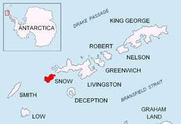 Location of Snow Island in the South Shetland Islands | |
 Baktriana Reef Location of Baktriana Reef  Baktriana Reef Baktriana Reef (South Shetland Islands) | |
| Geography | |
|---|---|
| Location | Antarctica |
| Coordinates | 62°45′51.5″S 61°33′38″W |
| Archipelago | South Shetland Islands |
| Area | 0.33 ha (0.82 acres) |
| Length | 360 m (1180 ft) |
| Width | 40 m (130 ft) |
| Administration | |
| Administered under the Antarctic Treaty | |
| Demographics | |
| Population | uninhabited |

The feature is so named because of its shape supposedly resembling the two humps of a Bactrian camel (‘baktriana’ in Bulgarian).
Location
Baktriana Reef lies in Boyd Strait at 62°45′51.5″S 61°33′38″W,[2] which is 2.96 km southwest of Byewater Point, 1.8 km northwest of Esteverena Point and 2.7 km north-northeast of Castle Rock. British mapping in 1968.
See also
Maps
- South Shetland Islands. Scale 1:200000 topographic map. DOS 610 Sheet W 62 60. Tolworth, UK, 1968
- L. Ivanov. Antarctica: Livingston Island and Greenwich, Robert, Snow and Smith Islands. Scale 1:120000 topographic map. Troyan: Manfred Wörner Foundation, 2010. ISBN 978-954-92032-9-5 (First edition 2009. ISBN 978-954-92032-6-4)
- Antarctic Digital Database (ADD). Scale 1:250000 topographic map of Antarctica. Scientific Committee on Antarctic Research (SCAR). Since 1993, regularly upgraded and updated
Notes
- L. Ivanov. General Geography and History of Livingston Island. In: Bulgarian Antarctic Research: A Synthesis. Eds. C. Pimpirev and N. Chipev. Sofia: St. Kliment Ohridski University Press, 2015. pp. 17–28
- Bulgarian Antarctic Gazetteer. Antarctic Place-names Commission
References
- Bulgarian Antarctic Gazetteer. Antarctic Place-names Commission. (details in Bulgarian, basic data in English)
External links
- Baktriana Reef. Adjusted Copernix satellite image
This article includes information from the Antarctic Place-names Commission of Bulgaria which is used with permission.
This Snow Island location article is a stub. You can help Wikipedia by expanding it. |
На других языках
[de] Baktriana Reef
Das Baktriana Reef (englisch, bulgarisch риф Бактриана .mw-parser-output .Latn{font-family:"Akzidenz Grotesk","Arial","Avant Garde Gothic","Calibri","Futura","Geneva","Gill Sans","Helvetica","Lucida Grande","Lucida Sans Unicode","Lucida Grande","Stone Sans","Tahoma","Trebuchet","Univers","Verdana"}rif Baktriana) ist ein 360 m langes, 40 m breites, flaches und felsiges Riff vor der Westküste von Snow Island im Archipel der Südlichen Shetlandinseln. Es liegt 2,96 km südwestlich des Byewater Point, 1,8 km nordwestlich des Esteverena Point und 2,7 km nordnordöstlich des Castle Rock.- [en] Baktriana Reef
Другой контент может иметь иную лицензию. Перед использованием материалов сайта WikiSort.org внимательно изучите правила лицензирования конкретных элементов наполнения сайта.
WikiSort.org - проект по пересортировке и дополнению контента Википедии