geo.wikisort.org - Mountains
Nevado del Huila (/nɛˈvɑːdoʊ dɛl ˈwiːlə/, Spanish pronunciation: [neˈβaðo ðel ˈwila]) at 5,364 metres (17,598 ft),[1] is the highest volcano in Colombia, located at the tripoint of the departments of Huila, Tolima and Cauca. It is visible from the city of Cali.[2] The andesitic volcano is located on top of the Ibagué Batholith.[3]
| Nevado del Huila | |
|---|---|
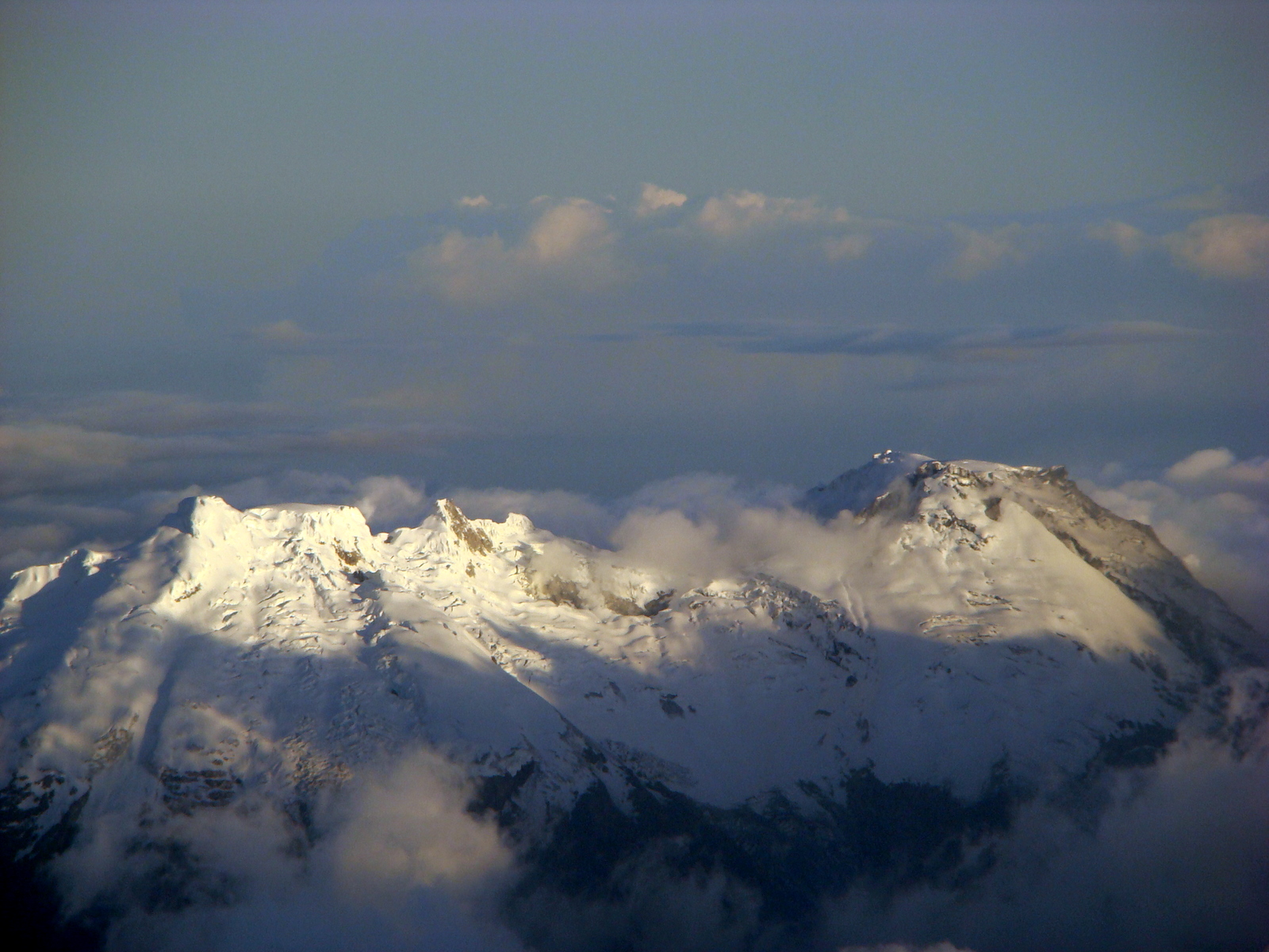 Nevado del Huila in December 2008 | |
| Highest point | |
| Elevation | 5,364 m (17,598 ft) |
| Prominence | 2,650 m (8,690 ft) |
| Listing | Ultra |
| Coordinates | 02°55′48″N 76°01′48″W |
| Geography | |
 Nevado del Huila Location of Nevado del Huila in Colombia | |
| Location | Cauca, Huila & Tolima |
| Parent range | Central Ranges Andes |
| Geology | |
| Mountain type | Andesitic stratovolcano |
| Volcanic arc/belt | North Volcanic Zone Andean Volcanic Belt |
| Last eruption | 2008 to 2012 |
After being dormant for more than 500 years, the volcano showed heavy signs of activity in 2007 and 2008. As of February 20, 2007, there were more than 7000 "minor" seismic events, and a high state of alert was in place for the departments of Cauca, Huila, Caldas and Valle del Cauca.[4] The volcano erupted twice in April 2007, once in April 2008 and again in November 2008. Any eruption would affect the small villages around the volcano, mostly Páez, where their inhabitants still have in memory the eruption of the Nevado del Ruiz volcano and the destruction of Armero.
Eruptions
2007 eruption
On April 18, 2007, the volcano erupted twice causing avalanches into the Paez River; this event caused water levels to rise along the Magdalena River. More than 4,000 people were evacuated with no casualties reported.[5][6]
2008 activity and eruption
Nevado del Huila became active again in March 2008. After a multitude of earthquakes inside the volcano, Colombian authorities declared a state of yellow alert on March 18.[7] The state of alert was increased to orange on March 29, meaning an eruption could be expected within two weeks. Hundreds of people were evacuated.[8] On April 14, 2008 at 11:08 pm, an ash eruption took place, prompting the government to issue a red alert and evacuate 13,000 to 15,000 people from around the mountain.[9] The state of red alert was again lowered to orange on April 16, following diminished activity.[10]
November 2008 eruption
On November 20, 2008, the volcano erupted at 02:45 GMT (at 21:45 on November 20 local time) according to Colombian Institute of Geology and Mining.[11] An immediate mass-scale evacuation was put in motion by the Colombian authorities, which the inhabitants of some towns reportedly refused. There were no injured reported at the time.[12] On November 23, 2008, BBC News, citing Colombian authorities, announced that the eruption had claimed ten lives, with 12,000 nearby residents being evacuated and emergency services unable to reach many of the more remote affected locations.[13] The eruption had triggered an avalanche of earth and debris that damaged houses, bridges and crops on plantations.[14] The three small towns of Paicol, La Plata and Belalcázar along the Páez River were affected by this eruption.[15]
Extensive instrumentation of the volcano, put in place by the existing national system for prevention and care of disasters,[16] which includes training of local inhabitants in high-risk regions and deployment of alarms in nearby towns, reportedly prevented large-scale deaths.[11] President Álvaro Uribe ordered the Air Force of Colombia to create an "air bridge" to provide supplies for cut off towns along the Páez River.[17]
See also
- List of volcanoes in Colombia
- List of volcanoes by elevation
References
- "Global Volcanism Program | Nevado del Huila". volcano.si.edu. Retrieved 2018-07-20.
- Paz, Manuel María. "View of Cali and of the Snow-Capped Mount Huila, Province of Buenaventura". World Digital Library. Retrieved 2014-05-22.
- Plancha 322, 1999
- (in Spanish) Reducción de actividad sísmica de Nevado del Huila aligera estado de emergencia en zonas cercanas, El Tiempo, February 20, 2007. Accessed February 20, 2007.
- (in Spanish) Mudslides occurred, but like in many eruptions, lava was not present.Destrucción de cuatro puentes y numerosos cultivos deja a su paso avalancha en el Cauca, El Tiempo
- "Thousands flee from Colombia volcano". CNN. Archived from the original on April 29, 2007. Retrieved 2008-11-24.
- Yellow alert for Colombian volcano Nevado del Huila
- State of alert volcano Nevado del Huila raised to orange
- Colombian volcano erupts in shower of hot ash; authorities declare alert, International Herald Tribune, April 15, 2008.
- Reduced activity Nevada de Huila volcano, Colombia Reports, April 16, 2008.
- "Nevado del Huila Volcano Erupts in Colombia". Latin America Herald Tribune. November 23, 2008. Retrieved 2008-11-23.
- "Nevado del Huila volcano erupts; thousands evacuated". Colombia Reports. November 23, 2008. Retrieved 2008-11-20.
- "Colombia volcano claims 10 lives". BBC News. November 23, 2008. Retrieved 2008-11-23.
- "Crops damaged by Colombian volcano eruption". Fairfax New Zealand. November 22, 2008. Retrieved 2008-11-23.
- "Volcano erupts in southern Colombia". Miami Herald. November 21, 2008. Retrieved 2008-11-23.[dead link]
- Dirección Nacional para la Prevención y Atención de Desastres[permanent dead link]
- "Colombian volcano sets off landslides". Associated Press. November 22, 2008. Retrieved 2008-11-23.
Bibliography
- ; ; , and . 1999. Plancha 322 - Santa María - 1:100,000, 1. INGEOMINAS. Accessed 2017-06-06.
External links
Protected areas of Colombia | ||
|---|---|---|
| National Natural Parks |
|  |
| Flora and Fauna Sanctuaries | ||
| National Natural Reserves |
| |
| Unique Natural Area |
| |
| Road parks |
| |
| Regional Nature Reserves |
| |
| Proposed Areas |
| |
| ||
Treasures of Colombia | |||||||||||||||||||||||||||||||||||||||||||||||||||||||||||||||
|---|---|---|---|---|---|---|---|---|---|---|---|---|---|---|---|---|---|---|---|---|---|---|---|---|---|---|---|---|---|---|---|---|---|---|---|---|---|---|---|---|---|---|---|---|---|---|---|---|---|---|---|---|---|---|---|---|---|---|---|---|---|---|---|
| |||||||||||||||||||||||||||||||||||||||||||||||||||||||||||||||
| |||||||||||||||||||||||||||||||||||||||||||||||||||||||||||||||
| |||||||||||||||||||||||||||||||||||||||||||||||||||||||||||||||
| |||||||||||||||||||||||||||||||||||||||||||||||||||||||||||||||
| |||||||||||||||||||||||||||||||||||||||||||||||||||||||||||||||
Source: Wills, Fernando; et al. (2001). Nuestro patrimonio – 100 tesoros de Colombia [Our heritage – 100 treasures of Colombia] (in Spanish). El Tiempo. pp. 1–311. ISBN 958-8089-16-6. | |||||||||||||||||||||||||||||||||||||||||||||||||||||||||||||||
| Western Ranges | | |
|---|---|---|
| Central Ranges |
| |
| Eastern Ranges | ||
| Other |
| |
| Source |
| |
На других языках
[de] Nevado del Huila
Der Nevado del Huila [.mw-parser-output .IPA a{text-decoration:none}neˈβaðo ðel ˈwila] ist ein aktiver Vulkan der Zentralkordillere Kolumbiens mit einer Höhe von 5364 m.[1] Anderen, veralteten Quellen zufolge ist er mit 5750 m wesentlich höher.[2] Dergleichen unterschiedliche Angaben zur Höhe von Vulkanen hängen meist mit ihrem jeweiligen Zustand zu einem bestimmten Zeitpunkt zusammen. Durch Eruptionen verändert sich die Höhe solcher Berge ständig.- [en] Nevado del Huila
[es] Nevado del Huila
El Nevado del Huila es un estratovolcán activo localizado en la Cordillera Central de Colombia. Su cima alcanza los 5.364 m s. n. m. siendo la cuarta montaña más alta del país después de los picos gemelos de la Sierra Nevada de Santa Marta y del Ritacuba Blanco. El nevado, que es el punto central del Parque Nacional Natural Nevado del Huila, está dividido territorialmente entre los departamentos de Huila, Tolima y Cauca, siendo su cima el punto más elevado de los tres. Posee un casquete glaciar de más de 20 km².[fr] Nevado del Huila
Le Nevado del Huila est un volcan de Colombie situé dans le département de Huila, dans la cordillère des Andes[1]. Avec une altitude comprise entre 5 364 et 5 750 mètres, il est le volcan actif le plus haut de Colombie[1].[it] Nevado del Huila
Il Nevado del Huila è un vulcano situato nel dipartimento colombiano di Huila, nelle Ande. Con i suoi 5.365 metri sul livello del mare, è il vulcano attivo più alto della Colombia e principale vetta della Cordillera Central.[ru] Уила (вулкан)
Уи́ла[2][3] (исп. Nevado del Huila [ne'βaðo ðel 'wila]) — самый высокий (высота 5365 метров) вулкан в Колумбии, расположен в департаменте Уила. Вулкан спал более 500 лет и начал показывать признаки активности в 2007 году. К 20 февраля 2007 года произошло свыше 7000 «незначительных» сейсмических событий. Сейсмическая опасность высока для департаментов Уила, Каука, Калдас, Валье-дель-Каука.[4]Другой контент может иметь иную лицензию. Перед использованием материалов сайта WikiSort.org внимательно изучите правила лицензирования конкретных элементов наполнения сайта.
WikiSort.org - проект по пересортировке и дополнению контента Википедии