geo.wikisort.org - Mountains
Quilotoa (Spanish pronunciation: [kiloˈto.a]) is a water-filled crater lake and the most western volcano in the Ecuadorian Andes. The 3-kilometre (2 mi)-wide caldera was formed by the collapse of this dacite volcano following a catastrophic VEI-6 eruption about 800 years ago, which produced pyroclastic flows and lahars that reached the Pacific Ocean, and spread an airborne deposit of volcanic ash throughout the northern Andes.[1] This last eruption followed a dormancy period of 14,000 years and is known as the 1280 Plinian eruption.[2] The fourth (of seven) eruptive phase was phreatomagmatic, indicating that a Crater lake was already present at that time.[3] The caldera has since accumulated a 250-metre-deep (820 ft) crater lake, which has a greenish color as a result of dissolved minerals. Fumaroles are found on the lake floor and hot springs occur on the eastern flank of the volcano.[1]
| Quilotoa | |
|---|---|
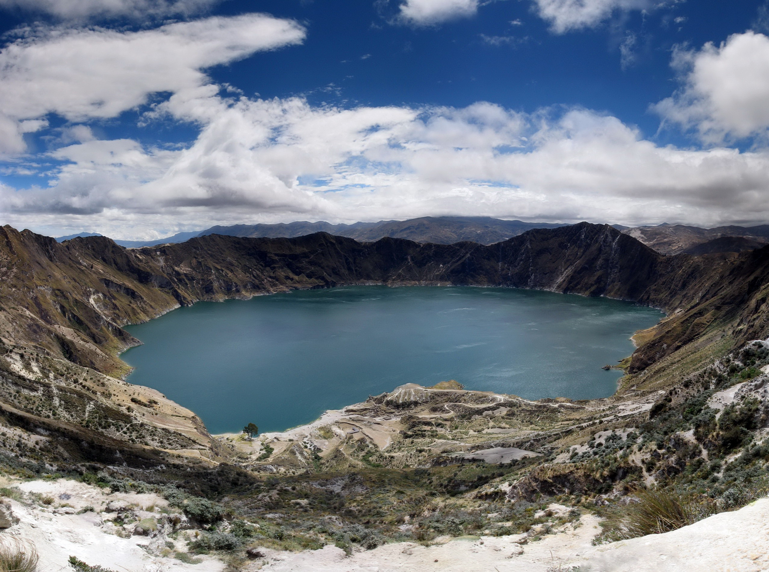 Panorama of the lake-filled Quilotoa caldera. | |
| Highest point | |
| Elevation | 3,914 m (12,841 ft)[1] |
| Prominence | 302 m (991 ft) |
| Listing | List of volcanoes in Ecuador |
| Coordinates | 0°51′S 78°54′W[1] |
| Geography | |
| Location | Pujilí Canton, Cotopaxi Province, Ecuador |
| Parent range | Andes |
| Geology | |
| Age of rock | approx. 40,000 years |
| Mountain type | Caldera |
| Last eruption | 1280[1] |

Quilotoa is a tourist site of growing popularity. The route to the "summit" (the small town of Quilotoa) is generally traveled by hired truck or bus from the town of Zumbahua 17 kilometres (11 mi) to the South, or more commonly by bus from Latacunga. Visitors have to pay two US dollars each to enter Quilotoa. There are a number of simple hostels in the immediate area offering services such as mules and guides. Activities include a four to five-hour hike around the caldera (whose diameter is just over 3 kilometres (2 mi)). The caldera rim is highly irregular and reaches its maximum elevations (3,810 metres (12,500 ft) to the N, (3,894 metres (12,776 ft) to the NW and (3,915 metres (12,844 ft) to the SE) at three lava domes. The (10-kilometre (6 mi) hike is sandy and steep in places and can be quite taxing, particularly if there is fog.
It is a half-hour hike down from the viewpoint (and 1- to 2-hour hike back up the (280-metre (919 ft) vertical ascent), and very basic lodging down in its bowl. Camping is permitted at the bottom of the crater, but there is no potable water (except half-litre bottles sold at the hostel)[4]
The lake surface is located at (3,500 metres (11,483 ft) asl. The total volume of water stored in Lake Quilotoa is (0.35 cubic kilometres (0.084 cu mi). According to local inhabitants, the lake level has been slowly declining over the last 10 years. Travertine deposits occur along the shore up to (10 metres (33 ft) above the lake level (in the year 2000).[3]
The village of Quilotoa and the associated crater is also a popular destination within the Quilotoa Loop and is a common starting point for the Quilotoa Traverse, a multi-day village to village hiking route.
See also
- Volcanic crater lake
References
- "Quilotoa". Global Volcanism Program. Smithsonian Institution. Retrieved 2007-01-25.
- Patricia A. Mothes, Minard L. Hall (2008) "The plinian fallout associated with Quilotoa's 800 yr BP eruption, Ecuadorian Andes", Journal of Volcanology and Geothermal Research, Volume 176, Issue 1, 10 September 2008, Pages 56-69
- "Water chemistry of Lake Quilotoa (Ecuador) and assessment of natural hazards" (PDF). Journal of Volcanology and Geothermal Research. 97: 271–285. 2000. Archived from the original (PDF) on 2012-02-16. Retrieved 2013-10-07.
- Viva Quilotoa Travel Guide site visit Jan 31, 2009
External links
| Wikimedia Commons has media related to Quilotoa. |
| Authority control |
|
|---|
На других языках
[de] Quilotoa
Quilotoa ist der Name einer Caldera und des darin befindlichen Kratersees, zugleich der westlichste Vulkan in den ecuadorianischen Anden.- [en] Quilotoa
[es] Quilotoa
El Quilotoa es un volcán lleno de agua en su cráter de 3 kilómetros (2 mi) de diámetro en su borde que se formó por el colapso de este volcán de dacita seguido por una erupción de VEI-6 hace aproximadamente 800 años, lo que produjo un flujo piroclástico y lahares (flujos de lodo) que alcanzaron el Océano Pacífico, que lanzó cenizas volcánicas a todo lo largo de los Andes septentrionales.[fr] Quilotoa
Le Quilotoa est un volcan d'Équateur culminant à 3 914 m, situé à une trentaine de kilomètres à l'ouest de Latacunga, capitale de la province de Cotopaxi. Il est situé au sud de la cordillère Occidentale.[it] Quilotoa
Il Quilotoa è un lago di origine vulcanica dell'Ecuador, situato nella provincia del Cotopaxi, nella parte occidentale delle Ande ecuadoriane.[ru] Килотоа
Килотоа (исп. Quilotoa) — вулкан конической формы в Эквадоре высотой 3914 метров над уровнем моря. Расположен на границе хребта Восточная Кордильера, в 35 километрах к западо-северо-западу от города Латакунга. В центре вулкана расположена кальдера диаметром около 3 километров, заполненная озером. Килотоа является самым западным вулканом эквадорских Анд.Другой контент может иметь иную лицензию. Перед использованием материалов сайта WikiSort.org внимательно изучите правила лицензирования конкретных элементов наполнения сайта.
WikiSort.org - проект по пересортировке и дополнению контента Википедии