geo.wikisort.org - Mountains
Sabancaya is an active 5,976-metre-high (19,606 ft) stratovolcano in the Andes of southern Peru, about 70 kilometres (43 mi) northwest of Arequipa. It is considered part of the Central Volcanic Zone of the Andes, one of the three distinct volcanic belts of the Andes. The Central Volcanic Zone includes a number of volcanoes, some of which like Huaynaputina have had large eruptions and others such as Sabancaya and Ubinas have been active in historical time. Sabancaya forms a volcanic complex together with Hualca Hualca to the north and Ampato to the south and has erupted andesite and dacite. It is covered by a small ice cap which leads to a risk of lahars during eruptions.
| Sabancaya | |
|---|---|
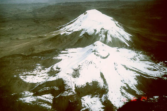
 Aerial view of Sabancaya, the summit in the left background is Ampato | |
| Highest point | |
| Elevation | 5,976 m (19,606 ft) |
| Prominence | ~500 m (1,640 ft) |
| Coordinates | 15.787°S 71.857°W[1][2] |
| Geography | |
 Sabancaya Peru | |
| Location | Southern Peru |
| Parent range | Andes |
| Geology | |
| Mountain type | Stratovolcano |
| Volcanic arc/belt | Central Volcanic Zone |
| Last eruption | September 2022 (ongoing) |
Sabancaya has generated numerous long lava flows especially during the early Holocene, while activity in the later Holocene has been more explosive. Historical reports indicate eruptions during the 18th century. The volcano returned to activity in 1986, culminating in a large eruption in 1990. Since then it has been continuously active with the emission of ash and gas.
Name
The name "Sabancaya" is Quechua and means tongue of fire[1] or spitting volcano, likely a reference to the eruptive activity.[3] The name is attested from 1595, implying that volcanic activity was observed since that date.[1]
Geography and geomorphology
Sabancaya lies about 70 km (43 mi) northwest of Arequipa.[4] The Rio Colca valley is located north of the Sabancaya-Hualca Hualca-Ampato volcano complex.[5] The principal economic activities in the area are agriculture, animal husbandry, mining and tourism.[6]
Regional
The subduction of the Nazca Plate beneath the South American Plate in the Peru-Chile Trench leads to volcanic activity in the Andes. This volcanic activity presently occurs in three segments, the Northern Volcanic Zone, the Central Volcanic Zone and the Southern Volcanic Zone. There is an additional volcanic belt south of the Southern Volcanic Zone, the Austral Volcanic Zone.[7] Sabancaya is located in the Central Volcanic Zone of the Andes, which extends through southern Peru.[8] Many volcanoes in the Central Volcanic Zone are poorly known, owing to their remote locations and adverse conditions such as high altitude.[7]
Sabancaya is part of a series of volcanoes that line the southwestern coast of Peru at a distance of roughly 100 kilometres (62 mi) from the shore. Of these volcanoes, Sabancaya, El Misti, Ubinas, Huaynaputina, Ticsani and Tutupaca have been active during historical time. Further volcanoes in the area with Pliocene-Quaternary activity are Sara Sara, Solimana, Coropuna, Ampato, Chachani, Yucamane, Casiri and Tacora.[9] All these volcanoes are considered part of the Central Volcanic Zone of the Andes,[10] and lie c. 150–200 kilometres (93–124 mi) east of the Peru-Chile Trench.[11] Notable among them are Ampato and Coropuna for exceeding a height of 6,000 metres (20,000 ft), Huaynaputina and El Misti for their large eruptions and Ubinas and Sabancaya for their recent activity.[12]
These volcanoes are found in places where strike-slip faults which delimit the volcanic arc and strike along its length intersect additional faults formed by extensional tectonics.[12] Such faults, mainly normal faults,[13] occur around Sabancaya as well and include the Huambo-Cabanaconde, the Huanca, the Ichupampa, the Pampa Sepina, Sepina,[14] Solarpampa and Trigal faults;[15] the volcanoes Ampato and Sabancaya are aligned on this fault, which may thus be responsible for their existence.[16] These fault systems are still active and experience occasional earthquakes and deformation,[17] and their activity appears to be in part triggered by underground magma movements at Sabancaya.[18]
Local
Sabancaya is 5,960 metres (19,554 ft)[1] high and rises 1,500 metres (4,920 ft) above the surrounding terrain.[19][20] It forms a group of volcanoes with the northern Hualca Hualca and the southern Ampato in the Cordillera Occidental,[4] which tower above the Colca Canyon in the north and the Siguas Valley in the southwest.[12] Ampato and the more heavily eroded Hualca Hualca are the dominant volcanoes of this group, with Sabancaya forming a northeastward extension of the former[5] 4–5 kilometres (2.5–3.1 mi) away from Ampato's summit.[16] There is evidence of age progression from the oldest, Hualca Hualca, over Ampato, to the youngest volcano, Sabancaya.[21]

Sabancaya consists of two separate centres that are formed by neighbouring domes, Sabancaya I North and Sabancaya II South.[22] The summit crater of the volcano lies between these two domes,[12] with traces of an additional crater just northeast.[23] Despite the presence of an ice cap, lava flows are recognizable in the summit area.[24] They have a total volume of 20–25 cubic kilometres (4.8–6.0 cu mi).[12]
A set of over 42 Holocene lava flows emanate from the volcano,[25][5] and cover a surface area of about 68 square kilometres (26 sq mi),[26] with individual lava flows extending up to 8 km (5.0 mi)[27] east and west from between its two neighbours. The lava flows at larger distances are older than the ones close to the vent.[2] These flows are blocky,[27] have lobe structures and reach thicknesses of 60–170 metres (200–560 ft);[26] the total thickness of this pile of lava flows is about 300–400 metres (980–1,310 ft).[25] Pyroclastic flow deposits are also found, but they might originate from Ampato rather than Sabancaya.[5]
Sabancaya, like its two neighbours, is covered by an ice cap[2] which in 1988 extended to distances of 2.5–3 kilometres (1.6–1.9 mi) from the summit.[20] In 1997, a surface area of 3.4 square kilometres (1.3 sq mi) was reported.[22] Between 1986 and 2016 the mountain lost over three quarters of its ice cap, and the remaining ice field broke up into several ice bodies.[28] Moraines at elevations of 4,450–4,250 metres (14,600–13,940 ft) above sea level testify to the occurrence of more extensive glaciation during the last ice age between 25,000 and 17,000 years before present;[29] these moraines have diverted some lava flows.[4] Younger moraines are found at higher altitudes, 4,400–4,650 metres (14,440–15,260 ft) above sea level, and may have formed between 13,000 and 10,000 years ago, shortly after the beginning of the Holocene.[29]
Earthquake activity has allowed the identification of a candidate magma reservoir beneath Pampa Sepina northeast of Sabancaya about 10 kilometres (6.2 mi) away from the summit. Between 1992 and 1996 this area inflated at a depth of 11–13 km (6.8–8.1 mi) below sea level, indicating that the magma supply system of Sabancaya may not be centered directly below the volcano.[30] Indeed, a phase of ground uplift at Hualca Hualca volcano and earthquake swarms in 1990 and later seismic activity under Hualca Hualca could indicate that the magma chamber of Sabancaya is actually under the neighbouring volcano, a not uncommon phenomenon at volcanoes.[31][32]
Geology
The tectonic conditions in the region have not been constant over time; at various times the plates approached each other at higher speed, and this led to a compressional tectonic regimen. In the Western Cordillera however, tensional faulting facilitated the occurrence of voluminous volcanism. This faulting is still underway and produces earthquakes in the area.[10]
The basement of the volcano is formed by Precambrian rocks, which are overlaid by various sediments and volcanic formations of Mesozoic and Cenozoic age. Especially during the Neogene, the supply of volcanic material was high and dominated the region, forming a volcanic "foot"; the present volcanoes are constructed on this volcanic "foot".[10] This "foot" is made out of an ignimbrite plateau that drops down south.[16] The "foot" beneath Ampato, Hualca Hualca and Sabancaya has been dated 2.2 ±0.15 million years ago, while a lava flow beneath the first and the last of these is about 0.8 ±0.04 million years old.[27]
Composition

Fresh volcanites of Sabancaya consist of porphyritic[27] andesite and dacite which form a potassium-rich calc-alkaline suite similar to other volcanoes in southern Peru;[33] the andesites occasionally appear as fine-grained enclaves.[34] The rocks are not very vesicular and contain a moderate amount of phenocrysts. Minerals encountered in both phenocrysts and groundmass are amphibole, biotite, hornblende, iron oxide, plagioclase, pyroxene and titanium oxide;[35] degraded olivine is also found.[12]
The magmas formed at temperatures of 920–990 °C (1,688–1,814 °F) with uncertainties of 30–50 °C (54–90 °F); the highest temperatures are associated with the 1992 eruption products.[33] Isotope data indicate that the pre-magmas interacted with the crust at great depths before rising to shallower magma chambers.[36] In these shallower magma chambers, magma genesis involved processes of magma mixing which formed at least part of the andesites[37] and fractional crystallization which gave rise to the dacites.[38] Partial crystallization and flow events within the magma chamber caused the formation of the andesite enclaves.[39] The total magma production rate of Sabancaya without accounting for repose periods is about 0.6–1.7 cubic kilometres per year (0.14–0.41 cu mi/a).[40]
Sabancaya is a source of volcanic gases such as SO
2 and H
2O. The amount of water emitted by Sabancaya is noticeably large for a volcano (about 250,000 tonnes per day or 2.9 tonnes per second); the source of this water might be an evaporating hydrothermal system in the volcano.[41] Together with Ubinas Sabancaya is among the main emitters of CO
2 and H
2O in the Central Volcanic Zone of the Andes and among the top fifteen volcanic emitters on Earth.[42]
Eruptive history
Initially, Ampato volcano was the active volcano before volcanism shifted to Sabancaya, after a period where both volcanoes erupted.[43] Presently, most activity at Sabancaya occurs in the form of lava domes and lava flows, one of which is dated to 5,440 ±40 years before present on the eastern flank.[27] Additional surface exposure dating has yielded ages of 6,650 ±320 and 6,300 ±310 on various lava flows, indicating that effusive activity started shortly after the beginning of the Holocene[25] although the basal part of the edifice did not exist yet at that time.[44] Pyroclastic eruptions are less common and have a low volume, with one such occurrence dated to 8,500 years before present.[27] This tephra layer, along with layers dated 2500-2100 BC, 420–150 BC, 100 BC – 150 AD[45] and between 1200 and 1400 AD, could have originated either on Sabancaya or Ampato, however.[46] There is evidence that early and middle-Holocene Sabancaya mostly erupted lava, while the late-Holocene volcano was more explosive in its activity.[47] It is possible that the Inca performed human sacrifices in response to eruptions of Sabancaya to calm down the mountain spirits.[48]

Spanish chronicles mention probable eruptions in 1752 and 1784, which might have left layers of tephra.[3] After the 18th century, the volcano went dormant for about two hundred years[27] during which only fumarolic activity was recorded.[49] In late 1986 an increased fumarolic activity heralded the onset of a new eruptive period,[27] and satellite images observed the occurrence of black spots where the ice had melted or boiled away.[20] During this time, the death of animals was observed in the area.[50] This period reached a climax in May 1990, when an eruption with a volcanic explosivity index of 2–3 occurred. This eruption threw ash to distances of 12 kilometres (7.5 mi) from the summit and was accompanied by strong earthquake activity and the formation of eruption columns that reached heights of 7 km (4.3 mi).[27] The eruption and further activity, through 1990, enlarged the summit crater and caused the formation of new rows of fumaroles.[20] Chemical analysis, of the volcanic rocks, suggests that this phase of volcanic activity was started by the injection of mafic magma into the magma chamber.[30] This eruption displaced between 4,000 and 1,500 people in the region.[51]
After the large 1990 eruption, the style of activity at Sabancaya changed towards a frequent occurrence of explosive eruptions with however low output,[52] which threw ballistic blocks to distances of about 1 kilometre (0.62 mi) from the summit crater;[9] this pattern of activity is referred to as "Vulcanian eruptions".[3] Ash fall from these eruptions induced melting of the glaciers on Ampato, in 1995 exposing the Mummy Juanita on the latter volcano.[53] These explosive eruptions became less common over time (from paroxysms every 20–30 minutes to only 5–6 eruptions per day)[27] and the proportional amount of fresh volcanic material increased at first; since 1997 discontinuous eruptions generate steam columns no higher than 300–500 metres (980–1,640 ft)[27] and ejected material is almost entirely lithic.[35] Satellite imagery has evidenced the occurrence of temperature anomalies on Sabancaya on the scale of 13 K (23 °F), probably owing to fumarolic activity.[54]
In March and April 2013, fumarolic activity and the occurrence of seismic swarms increased[16] leading to local infrastructure being damaged;[50] an eruption occurred in August 2014.[55] This pulse of activity was accompanied by an increased release of SO
2, which was being emitted at a rate of 1,000 tonnes per day (0.012 t/s) in 2014.[50] Ash was emitted by the volcano multiple times through 2014 and 2015,[56] and there has been steady shallow seismic activity since 2013.[57]
A further increase of fumarolic activity was observed in 2016, when new fumaroles appeared and sulfur flux increased to 6,000 tonnes per day (0.069 t/s) sulfur dioxide. Ash eruptions have occurred since 6 November 2016, with an eruption column 3 km (1.9 mi) high five days later.[50] This renewed activity was accompanied by ground uplift at Hualca Hualca north of Sabancaya, indicating the role of a shared magmatic system between the two volcanoes.[18] Since then, the volcano has been continuously active[58] with numerous explosions every day, which produce volcanic ash clouds that can rise to elevations of 3.5 km (2.2 mi).[59] A persistent gas plume lies above the volcano and repeated emissions of ash have happened, resulting in several alerts for the local population.[56] Lahars have been produced in some occasions, without reports of damage.[60] A lava dome began to grow in 2017 within the crater, with unsteady explosive activity and occasional seismic swarms.[61] In 2020, a second lava dome formed in November[62] but it was destroyed between December and February of that year.[63] Ash emissions and seismic activity continued through 2021 and 2022.[64]
Hazards

Sabancaya rises above the valleys of the Colca river and of some tributaries of the Siguas river with about 35,000 people living in them.[65] Sabancaya is particularly dangerous for the Colca river valley,[66] 18 kilometres (11 mi) north of the volcano;[67] it is a major tourism destination in Peru[68] with about 190,000 visitors per year[6] and with the towns Achoma, Cabanaconde, Chivay, Ichupampa, Lari, Maca, Madrigal, Pinchollo, Yanque and others.[66] About 30,000 people live within 30 kilometres (19 mi) from the volcano.[15] The flanks of Sabancaya themselves include roads and a major power line that comes from the Mantaro Power Plant and delivers electricity to southern Peru; all of these could be threatened in an eruption.[66] In the case of a major Plinian eruption, at least 60,000 to 70,000 people would be threatened. Rock fall would affect the area close to the summit domes, as would pyroclastic flows; these would be a further hazard to the valleys draining the volcano.[65]
The presence of an ice cap is an additional source of danger,[69] as its melting during a volcanic eruption could form hazardous lahars,[65] although the small volume of the ice cap limits their damage potential.[70] The Majes River and Sihuasi River drainages would be threatened by such mudflows in case of an eruption;[71] the former is the site of a major irrigation project.[66] Other dangers from eruptions at Sabancaya are tephra fallout, which can impact the health of people;[72] and lava flows, which however are not much of a threat to humans owing to their slow speed.[73]
Volcano monitoring in Peru commenced after the 1986 eruption, with the Southern Volcano Observatory being created two years later and beginning its work at Sabancaya. The monitoring network around the volcano was expanded after its 2013 eruption.[58] The Peruvian Volcanological Observatory monitors Sabancaya with infrasound detectors, seismometers, surveillance cameras,[74][50] telemetry units[75] and also uses data from satellites[62] and volcanic ash collectors;[76] it has published a hazard map.[77] In 2005, monitoring commenced of the gas emissions from Sabancaya.[78] Aside from the direct threat of eruptions, Sabancaya also contributes to SO
2 air pollution in the Colca valley, which can damage plants and cause respiratory distress in animals and humans.[79] Ash clouds from Sabancaya frequently impede air travel over the region; the volcano is one of the most frequent causes of volcanic ash-related air traffic advisories in the world.[80]
See also
References
- "Sabancaya". Global Volcanism Program. Smithsonian Institution.
- Gerbe & Thouret 2004, p. 541.
- Thouret et al. 1994, p. 51.
- Warner & Gregg 2003, p. 5.
- Juvigné et al. 2008, p. 160.
- Rivera et al. 2021, p. 35.
- Silva & Francis 1990, p. 287.
- Samaniego et al. 2016, p. 110.
- Gerbe & Thouret 2004, p. 542.
- Gerbe & Thouret 2004, p. 543.
- Silva & Francis 1990, p. 299.
- Thouret et al. 1994, p. 49.
- MacQueen et al. 2020, p. 4.
- Jay et al. 2015, p. 2780.
- Del Carpio Calienes & Rivera 2020, p. 4.
- Samaniego et al. 2016, p. 112.
- Jay et al. 2015, p. 2786.
- MacQueen et al. 2020, p. 21.
- Silva & Francis 1990, p. 288.
- Chorowicz, J.; Deffontaines, B.; Huaman-Rodrigo, D.; Guillande, R.; Leguern, F.; Thouret, J.C. (1992-10-01). "SPOT satellite monitoring of the eruption of Nevado Sabancaya volcano (Southern Peru)". Remote Sensing of Environment. 42 (1): 45. Bibcode:1992RSEnv..42...43C. doi:10.1016/0034-4257(92)90066-S.
- Alcalá, J.; Zamorano, J. J.; Palacios, D. (2012-04-01). "Geomorphologic map and derived geomorphological evolution model of the Ampato volcanic complex (Southern Peru)". EGU General Assembly Conference Abstracts. 14: 3672. Bibcode:2012EGUGA..14.3672A.
- Legeley-Padovani, A.; Mering, C.; Guillande, R.; Huaman, D. (1997-10-01). "Mapping of lava flows through SPOT images an example of the Sabancaya volcano (Peru)". International Journal of Remote Sensing. 18 (15): 3113. Bibcode:1997IJRS...18.3111L. doi:10.1080/014311697217008. ISSN 0143-1161.
- Thouret et al. 1994, p. 50.
- Silva & Francis 1990, p. 292.
- Samaniego et al. 2016, p. 119.
- Warner & Gregg 2003, p. 2.
- Gerbe & Thouret 2004, p. 544.
- Reinthaler, Johannes; Paul, Frank; Granados, Hugo Delgado; Rivera, Andrés; Huggel, Christian (2019). "Area changes of glaciers on active volcanoes in Latin America between 1986 and 2015 observed from multi-temporal satellite imagery". Journal of Glaciology. 65 (252): 548, 550. Bibcode:2019JGlac..65..542R. doi:10.1017/jog.2019.30. ISSN 0022-1430.
- Samaniego et al. 2016, p. 113.
- Gerbe & Thouret 2004, p. 558.
- MacQueen et al. 2020, p. 16.
- Pritchard, Matthew E.; Simons, Mark (2002-07-11). "A satellite geodetic survey of large-scale deformation of volcanic centres in the central Andes". Nature. 418 (6894): 167–71. Bibcode:2002Natur.418..167P. doi:10.1038/nature00872. ISSN 0028-0836. PMID 12110886. S2CID 4342717.
- Gerbe & Thouret 2004, p. 549.
- Gerbe & Thouret 2004, p. 548.
- Gerbe & Thouret 2004, p. 545.
- Gerbe & Thouret 2004, p. 555.
- Gerbe & Thouret 2004, p. 553.
- Gerbe & Thouret 2004, p. 552.
- Gerbe & Thouret 2004, p. 557.
- Samaniego et al. 2016, p. 126.
- Kern et al. 2017, p. 3557.
- Moussallam et al. 2017, p. 185.
- Rivera, Marco; Samaniego, Pablo; Vela, Jessica; Le Pennec, Jean-Luc; Guillou, Hervé; Paquette, Jean-Louis; Liorzou, Céline (March 2020). "The eruptive chronology of the Yucamane-Calientes compound volcano: A potentially active edifice of the Central Andes (southern Peru)". Journal of Volcanology and Geothermal Research. 393: 17. Bibcode:2020JVGR..39306787R. doi:10.1016/j.jvolgeores.2020.106787. ISSN 0377-0273. S2CID 213760918.
- Bromley, Gordon R. M.; Thouret, Jean-Claude; Schimmelpfennig, Irene; Mariño, Jersy; Valdivia, David; Rademaker, Kurt; del Pilar Vivanco Lopez, Socorro; Team, ASTER; Aumaître, Georges; Bourlès, Didier; Keddadouche, Karim (7 November 2019). "In situ cosmogenic 3He and 36Cl and radiocarbon dating of volcanic deposits refine the Pleistocene and Holocene eruption chronology of SW Peru". Bulletin of Volcanology. 81 (11): 12. Bibcode:2019BVol...81...64B. doi:10.1007/s00445-019-1325-6. S2CID 207913276.
- Juvigné et al. 2008, p. 170.
- THOURET, Jean-Claude; DAVILA, Jasmine; JUVIGNÉ, Etienne; LEE, Alex; LEGELEY-PADOVANI, Annick; LOUTSCH, Isabelle; MAJAVESI, Medeia; JERSY, Marino; MOSCOL, Marcela (July 2003). "Late Pleistocene and Holocene Tephrostratigraphy and Chronology in Southern Peru". gsa.confex.com. Retrieved 2017-06-27.
- Samaniego et al. 2016, p. 127.
- Chávez Chávez, José Antonio (July 2001). "INVESTIGACIONES ARQUEOLÓGICAS de ALTA MONTAÑA en el Sur del Perú". Chungará (Arica) (in Spanish). 33 (2): 283–288. doi:10.4067/S0717-73562001000200014. ISSN 0717-7356.
- Moussallam et al. 2017, p. 182.
- Kern et al. 2017, p. 3544.
- Annen, Catherine; Wagner, Jean-Jacques (2003-11-01). "The Impact of Volcanic Eruptions During the 1990s". Natural Hazards Review. 4 (4): 171. doi:10.1061/(ASCE)1527-6988(2003)4:4(169).
- Gerbe & Thouret 2004, p. 541,543.
- Socha, Dagmara M.; Reinhard, Johan; Perea, Ruddy Chávez (14 May 2021). "Inca human sacrifices from the Ampato and Pichu Pichu volcanoes, Peru: new results from a bio-anthropological analysis". Archaeological and Anthropological Sciences. 13 (6): 5. doi:10.1007/s12520-021-01332-1. ISSN 1866-9565. S2CID 234489075.
- Jay, J. A.; Welch, M.; Pritchard, M. E.; Mares, P. J.; Mnich, M. E.; Melkonian, A. K.; Aguilera, F.; Naranjo, J. A.; Sunagua, M. (2013-01-01). "Volcanic hotspots of the central and southern Andes as seen from space by ASTER and MODVOLC between the years 2000 and 2010". Geological Society, London, Special Publications. 380 (1): 164. Bibcode:2013GSLSP.380..161J. doi:10.1144/SP380.1. ISSN 0305-8719. S2CID 129450763.
- Jay et al. 2015, p. 2787.
- "Sabancaya". Global Volcanism Program. Smithsonian Institution., Weekly Reports
- MacQueen et al. 2020, p. 3.
- Puma et al. 2021, p. 50.
- Puma Sacsi et al. 2021, p. 8.
- Rivera et al. 2021, pp. 35–36.
- Del Carpio Calienes & Rivera 2020, p. 8.
- Puma Sacsi et al. 2021, p. 6.
- Puma Sacsi et al. 2021, p. 17.
- Bennis, K.L.; Andrews, B. (eds.). Global Volcanism Program, 2022. Report on Sabancaya (Peru) (Report). Bulletin of the Global Volcanism Network. Vol. 47. Smithsonian Institution.
- Thouret et al. 1994, p. 55.
- "Volcán Sabancaya". INGEMMET (in Spanish). Retrieved 2017-07-01.
- Puma Sacsi et al. 2021, p. 5.
- Juvigné et al. 2008, p. 158.
- Thouret et al. 1994, p. 54.
- Thouret et al. 1994, p. 60.
- Silva & Francis 1990, p. 292,293.
- Del Carpio Calienes & Rivera 2020, p. 21.
- Del Carpio Calienes & Rivera 2020, p. 22.
- Del Carpio Calienes & Rivera 2020, p. 6.
- Puma et al. 2021, p. 52.
- Contreras et al. 2021, p. 77.
- "Mapa de peligros del volcán Sabancaya". INGEMMET (in Spanish). Retrieved 2017-07-01.
- Contreras et al. 2021, p. 75.
- Lizano, Jesús G; Heredia, Candy D. C (1999). "Evaluacion quimico-toxicologica de SO 2 en el aire del Valle del Colca". Ciencia e Investigación (in Spanish). 2 (1): 19. doi:10.15381/ci.v2i1.4403. ISSN 1609-9044.
- Engwell, S.; Mastin, L.; Tupper, A.; Kibler, J.; Acethorp, P.; Lord, G.; Filgueira, R. (21 January 2021). "Near-real-time volcanic cloud monitoring: insights into global explosive volcanic eruptive activity through analysis of Volcanic Ash Advisories". Bulletin of Volcanology. 83 (2): 7, 13. Bibcode:2021BVol...83....9E. doi:10.1007/s00445-020-01419-y. ISSN 1432-0819. S2CID 231668404.
Sources
- Contreras, Rigoberto Aguilar; Maquerhua, Edu Taipe; Vera, Yanet Antayhua; Gonzales, Mayra Ortega; Choquehuayta, Fredy Apaza; Mamani, Luis Cruz (1 November 2021). "Hazard assessment studies and multiparametric volcano monitoring developed by the Instituto Geológico, Minero y Metalúrgico in Peru". Volcanica. 4 (S1): 73–92. doi:10.30909/vol.04.S1.7392. ISSN 2610-3540. S2CID 240477849.
- Del Carpio Calienes, José Alberto; Rivera, Marco (February 2020). "Evaluación geofísica del comportamiento dinámico actual del volcán Sabancaya, periodo 1 de diciembre de 2019-2 de febrero de 2020". Repositorio Institucional - IGP (in Spanish).
- Gerbe, Marie-Christine; Thouret, Jean-Claude (2004-08-01). "Role of magma mixing in the petrogenesis of tephra erupted during the 1990–98 explosive activity of Nevado Sabancaya, southern Peru". Bulletin of Volcanology. 66 (6): 541–561. doi:10.1007/s00445-004-0340-3. ISSN 0258-8900. S2CID 128592747.
- Jay, Jennifer A.; Delgado, Francisco J.; Torres, José Luis; Pritchard, Matthew E.; Macedo, Orlando; Aguilar, Victor (2015-04-28). "Deformation and seismicity near Sabancaya volcano, southern Peru, from 2002 to 2015" (PDF). Geophysical Research Letters. 42 (8): 2015GL063589. Bibcode:2015GeoRL..42.2780J. doi:10.1002/2015GL063589. ISSN 1944-8007.
- Juvigné, Etienne; Thouret, Jean-Claude; Loutsch, Isabelle; Lamadon, Sébastien; Frechen, Manfred; Fontugne, Michel; Rivera, Marco; Dávila, Jasmine; Mariño, Jersy (2008-06-01). Jean-François Pastre. "Retombées volcaniques dans des tourbières et lacs autour du massif des Nevados Ampato et Sabancaya (Pérou méridional, Andes Centrales)". Quaternaire. Revue de l'Association Française Pour l'Étude du Quaternaire (in French). 19 (2): 157–173. doi:10.4000/quaternaire.3362. ISSN 1142-2904.
- Kern, Christoph; Masias, Pablo; Apaza, Fredy; Reath, Kevin A.; Platt, Ulrich (2017-05-01). "Remote measurement of high preeruptive water vapor emissions at Sabancaya volcano by passive differential optical absorption spectroscopy". Journal of Geophysical Research: Solid Earth. 122 (5): 2017JB014020. Bibcode:2017JGRB..122.3540K. doi:10.1002/2017JB014020. hdl:20.500.12544/1170. ISSN 2169-9356.
- MacQueen, Patricia; Delgado, Francisco; Reath, Kevin; Pritchard, Matthew E.; Bagnardi, Marco; Milillo, Pietro; Lundgren, Paul; Macedo, Orlando; Aguilar, Victor; Ortega, Mayra; Anccasi, Rosa; Zerpa, Ivonne Alejandra Lazarte; Miranda, Rafael (2020). "Volcano-Tectonic Interactions at Sabancaya Volcano, Peru: Eruptions, Magmatic Inflation, Moderate Earthquakes, and Fault Creep". Journal of Geophysical Research: Solid Earth. 125 (5): e2019JB019281. Bibcode:2020JGRB..12519281M. doi:10.1029/2019JB019281. ISSN 2169-9356. S2CID 218797689.
- Moussallam, Yves; Tamburello, Giancarlo; Peters, Nial; Apaza, Fredy; Schipper, C. Ian; Curtis, Aaron; Aiuppa, Alessandro; Masias, Pablo; Boichu, Marie; Bauduin, Sophie; Barnie, Talfan; Bani, Philipson; Giudice, Gaetano; Moussallam, Manuel (1 September 2017). "Volcanic gas emissions and degassing dynamics at Ubinas and Sabancaya volcanoes; implications for the volatile budget of the central volcanic zone". Journal of Volcanology and Geothermal Research. 343: 181–191. Bibcode:2017JVGR..343..181M. doi:10.1016/j.jvolgeores.2017.06.027. ISSN 0377-0273.
- Puma, Roger Machacca; Calienes, José Alberto Del Carpio; Porras, Marco Antonio Rivera; Huarache, Hernando Jhonny Tavera; Franco, Luisa Diomira Macedo; Calle, Jorge Andrés Concha; Zerpa, Ivonne Alejandra Lazarte; Quico, Riky Gustavo Centeno; Sacsi, Nino Celestino Puma; Aguilar, José Luis Torres; Alva, Katherine Andrea Vargas; Igme, John Edward Cruz; Quispe, Lizbeth Velarde; Nina, Javier Vilca; Garay, Alan Reinhold Malpartida (1 November 2021). "Monitoring of active volcanoes in Peru by the Instituto Geofísico del Perú: Early warning systems, communication, and information dissemination". Volcanica. 4 (S1): 49–71. doi:10.30909/vol.04.S1.4971. ISSN 2610-3540. S2CID 240447272.
- Puma Sacsi, Nino; Del Carpio Calienes, José Alberto; Rivera, Marco; Vargas Alva, Katherine Andrea; Machacca, Roger; Lazarte Zerpa, lvonne Alejandra (April 2021). Evaluación geofísica del comportamiento dinámico del volcán Sabancaya (diciembre, 2020 – marzo, 2021) (Report).
- Rivera, Marco; Del Carpio Calienes, José Alberto; Tavera, Hernando; Cruz Igme, John Edward; Vargas Alva, Katherine Andrea; Torres Aguilar, José Luis; Concha Calle, Jorge Andrés (February 2021). Análisis y evaluación de escenarios críticos por descenso de lahares en volcanes peruanos (Report).
- Samaniego, Pablo; Rivera, Marco; Mariño, Jersy; Guillou, Hervé; Liorzou, Céline; Zerathe, Swann; Delgado, Rosmery; Valderrama, Patricio; Scao, Vincent (2016-09-01). "The eruptive chronology of the Ampato–Sabancaya volcanic complex (Southern Peru)". Journal of Volcanology and Geothermal Research. 323: 110–128. Bibcode:2016JVGR..323..110S. doi:10.1016/j.jvolgeores.2016.04.038.
- Silva, SL de; Francis, P. W. (1990-03-01). "Potentially active volcanoes of Peru-Observations using Landsat Thematic Mapper and Space Shuttle imagery". Bulletin of Volcanology. 52 (4): 286–301. Bibcode:1990BVol...52..286D. doi:10.1007/BF00304100. ISSN 0258-8900. S2CID 140559785.
- Thouret, J. C.; Guillande, R.; Huaman, D.; Gourgaud, A.; Salas, G.; Chorowicz, J. (1994-01-01). "L9Activite actuelle du Nevado Sabancaya (sud Perou); reconnaissance geologique et satellitaire, evaluation et cartographie des menaces volcaniques". Bulletin de la Société Géologique de France (in French). 165 (1): 49–63. ISSN 0037-9409 – via https://www.researchgate.net/publication/283715955_L%27activite_actuelle_du_Nevado_Sabancaya_Sud-Perou_reconnaissance_geologique_et_satellitaire_evaluation_et_cartographie_des_menaces_volcaniques.
{{cite journal}}: External link in|via= - Warner, Nicholas H.; Gregg, Tracy K.P. (2003-10-01). "Evolved lavas on Mars? Observations from southwest Arsia Mons and Sabancaya volcano, Peru". Journal of Geophysical Research: Planets. 108 (E10): 5112. Bibcode:2003JGRE..108.5112W. doi:10.1029/2002JE001969. ISSN 2156-2202.
На других языках
[de] Sabancaya
Der Sabancaya ist ein 5976 m hoher, aktiver Stratovulkan in den Anden im Süden Perus und liegt etwa 100 km nordwestlich von Arequipa. Er ist der am stärksten aktive Vulkan in Peru und Teil einer 20 km langen Nord-Süd-Kette aus drei großen Stratovulkanen. Am nördlichen Ende findet sich der erloschene 6025 m hohe Nevado Hualca Hualca, am südlichen Ende der ruhende 6288 m hohe Nevado Ampato und in der Mitte der Sabancaya. Auf dem Vulkan gibt es etliche Gletscher, die eine Fläche von 3,5 km² bedecken und bis zu einer Höhe von 5400 m herabreichen.- [en] Sabancaya
[fr] Sabancaya
Le Sabancaya est un stratovolcan des Andes péruviennes surmonté d'une calotte glaciaire. Avec une altitude de 5 967 m, c'est le septième plus haut volcan actif du monde, après le Nevados Ojos del Salado (6 864 m, Argentine et Chili), le Sajama (6 542 m), l'Antofalla (6 409 m), el Cóndor (6 373 m), le Guallatiri (6 060 m) et le San Pedro du Chili (6 039 m), le huitième plus haut volcan actif du monde étant le Cotopaxi (5 897 m, Équateur).[it] Sabancaya
Il Sabancaya è uno stratovulcano del sud del Perù, nella catena montuosa delle Ande. Settimo più alto vulcano attivo del mondo, la sua cima è coperta da un ghiacciaio.[ru] Сабанкая
Сабанкая (исп. Volcán Sabancaya) — вулкан в Южной Америке на территории южного Перу.Другой контент может иметь иную лицензию. Перед использованием материалов сайта WikiSort.org внимательно изучите правила лицензирования конкретных элементов наполнения сайта.
WikiSort.org - проект по пересортировке и дополнению контента Википедии