geo.wikisort.org - Mountains
Lautaro Volcano is an active subglacial stratovolcano located in Chilean Patagonia, in the northern part of the Southern Patagonian Ice Field. Its summit rises roughly 2,000 m (6,600 ft) above the average surface of the ice cap plateau.[5] It is the tallest mountain in Bernardo O'Higgins National Park and in its vicinity lies Pío XI Glacier. In 1952 the volcano was given its name[4] in honor of Lautaro, who was a Mapuche military leader.
| Lautaro | |
|---|---|
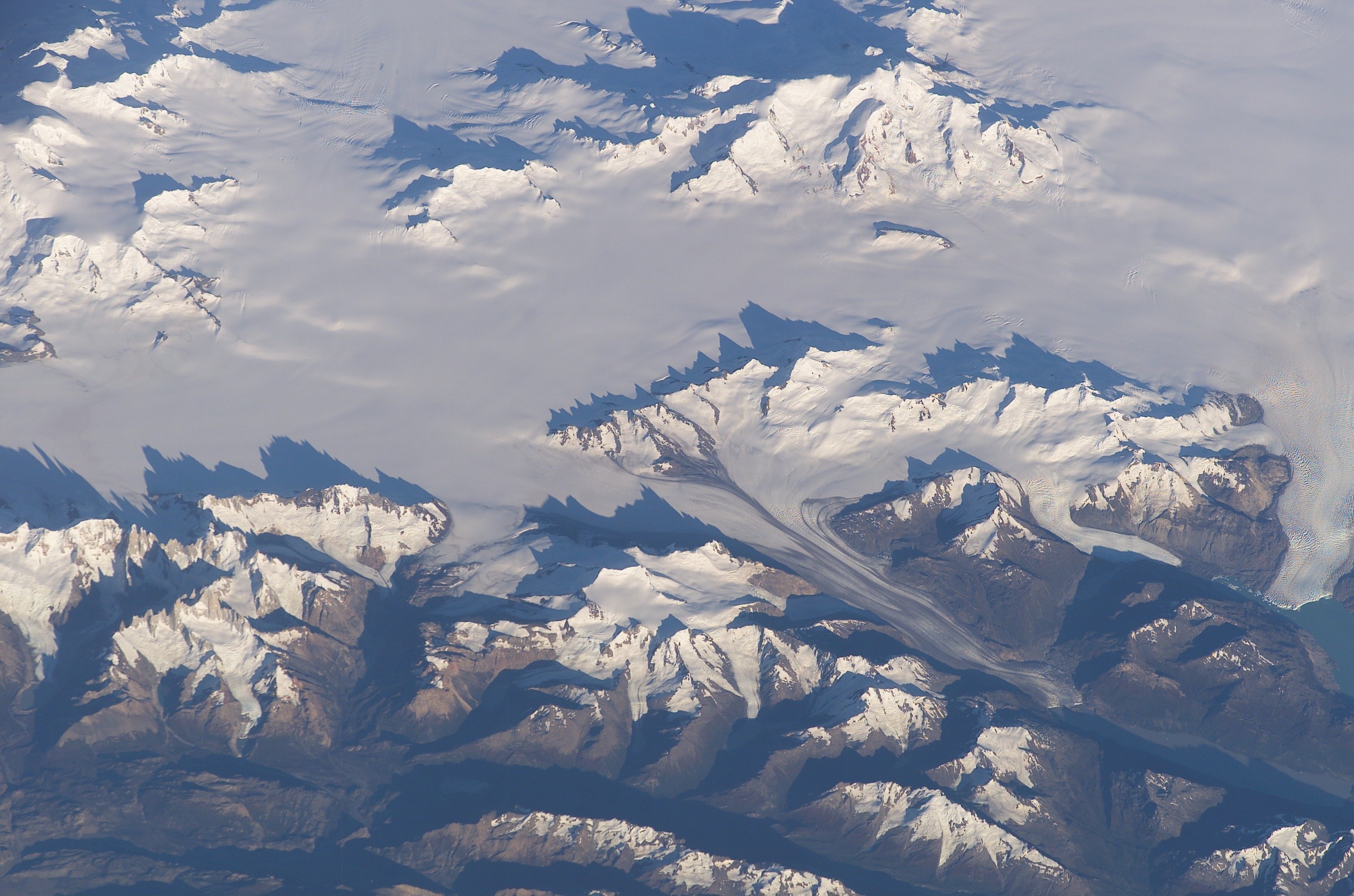 The volcano is visible in the upper portion of this NASA image, whereas Mount Fitz Roy is in the lower left corner. | |
| Highest point | |
| Elevation | 3,623 m (11,886 ft)[1] |
| Prominence | 3,345 m (10,974 ft) Ranked 57th |
| Isolation | 182 km (113 mi) |
| Listing | Ultra |
| Coordinates | 49°01′10.8″S 73°30′12.5″W[1] |
| Geography | |
 Lautaro Location in Chile | |
| Location | Aisén, Chile |
| Parent range | Andes |
| Geology | |
| Mountain type | Stratovolcano |
| Volcanic arc/belt | Austral Volcanic Zone |
| Last eruption | March 1979 |
| Climbing | |
| First ascent | January 29, 1964 by Peter Skvarca and Luciano Pera[2][3][4] |
| Easiest route | snow/ice climb |
The first ascent of Lautaro was made by Peter Skvarca and Luciano Pera, on January 29, 1964. They climbed the southeast ridge, encountering many crevasses, some steep ice walls, cornices, and a snow mushroom at the summit. They found an active crater and strong sulfurous emissions near the summit.[2] The second ascent was made by Eric Jones, Mick Coffey, and Leo Dickinson on March 2, 1973, as part of a crossing of the Southern Patagonian Ice Field.[3]
See also
References
- The elevation and coordinates given here are from a 2007 GPS survey Archived 2016-03-04 at the Wayback Machine. Other sources give 3,607 metres but give no primary source.
- Vojslav Arko and Peter Skvarca, "Cerro Gorra Blanca and Volcán Lautaro", American Alpine Journal, 1964, p. 223.
- Leo Dickinson, "Lautaro", American Alpine Journal, 1974, p. 200-201. Available at AAJ Online Archived 2007-09-27 at the Wayback Machine (PDF). See the accompanying note by H. Adams Carter.
- USGS. "P 1386-I - Chile and Argentina - Wet Andes: Expeditions". Retrieved 2007-03-17.
-
MOTOKI, Akihisa, ORIHASHI, Yuji, NARANJO, José A; et al. (January 2006). "Geologic reconnaissance of Lautaro Volcano, Chilean Patagonia". Revista Geológica de Chile. Rev. geol. Chile. [online]. 33 (1): 177–187. doi:10.4067/S0716-02082006000100008. ISSN 0716-0208. Retrieved 2006-09-08.
{{cite journal}}: CS1 maint: multiple names: authors list (link)
- "Lautaro". Global Volcanism Program. Smithsonian Institution.
This Aysén Region location article is a stub. You can help Wikipedia by expanding it. |
На других языках
- [en] Lautaro (volcano)
[es] Volcán Lautaro
El volcán Lautaro es un volcán activo cubierto de hielo localizado en el Campo de Hielo Patagónico Sur, en la Patagonia chilena. Su cumbre se yergue más de mil metros por sobre la planicie de hielo del campo de hielo.[3] Es la montaña más alta del parque nacional Bernardo O'Higgins. Se ubica aledaño al glaciar Pío XI. La montaña fue nombrada en 1952 en honor a Lautaro, cacique mapuche del siglo XVI.[fr] Lautaro (volcan)
Le Lautaro est un volcan du Chili qui se présente sous la forme d'un stratovolcan couvert de glaciers et émergeant au-dessus du champ de glace Sud de Patagonie. Un cratère est situé juste en contrebas de son sommet qui culmine à 3 607 mètres d'altitude. Sa dernière éruption s'est produite le 8 mars 1979. Il est le volcan le plus septentrional de la zone volcanique australe des Andes.[it] Monte Lautaro
Il Lautaro è un vulcano esplosivo del sud del Cile, alto 3.607 metri. Si presenta ricoperto dai ghiacci del Campo di ghiaccio Patagonico Sud ed è compreso nel Parco nazionale Bernardo O'Higgins, di cui costituisce il punto più alto.Другой контент может иметь иную лицензию. Перед использованием материалов сайта WikiSort.org внимательно изучите правила лицензирования конкретных элементов наполнения сайта.
WikiSort.org - проект по пересортировке и дополнению контента Википедии