geo.wikisort.org - Mountains
Lanín is an ice-clad, cone-shaped stratovolcano on the border of Argentina and Chile. It forms part of two national parks: Lanín in Argentina and Villarrica in Chile. It is a symbol of the Argentine province of Neuquén, being part of its flag and its anthem. Although the date of its last eruption is not known, it is estimated to have occurred within the last 10,000 years. Following the 1906 Valparaíso earthquake a local newspaper reported the volcano to have erupted, but a work published in 1917 by Karl Sapper disputed this.[3]
| Lanín | |
|---|---|
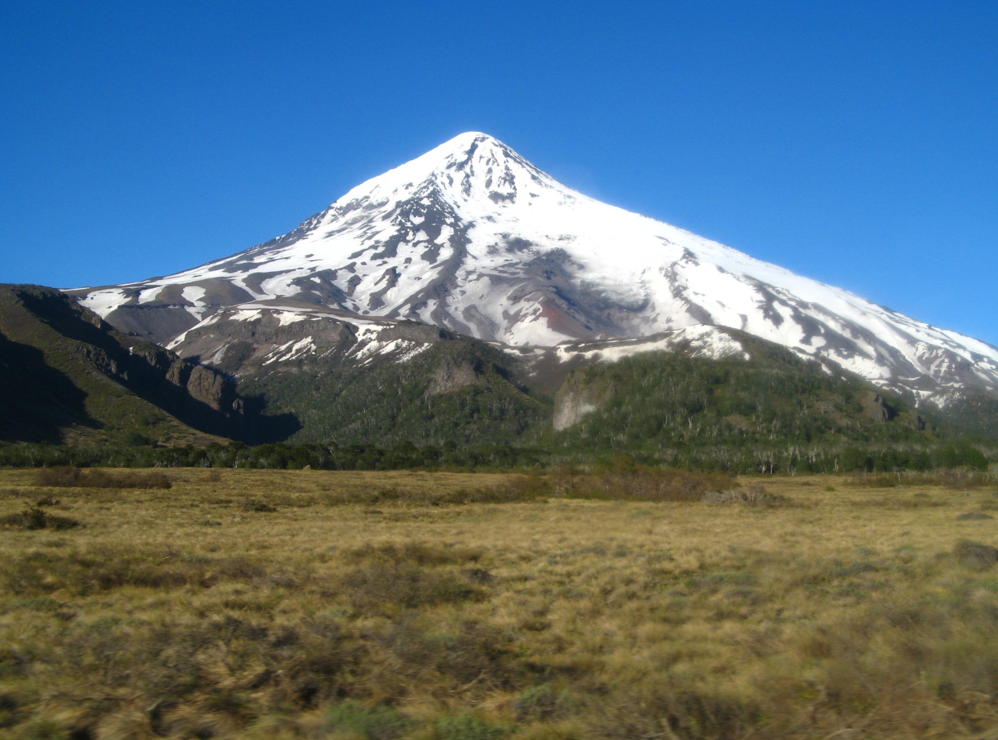 Lanín as seen from Mamuil Malal Pass | |
| Highest point | |
| Elevation | 3,776 m (12,388 ft)[1] |
| Prominence | 2,624 m (8,609 ft)[2] |
| Listing | Region high point Ultra |
| Coordinates | 39°37′58″S 71°29′59″W[1] |
| Geography | |
 Lanín Location in Argentina, on the border with Chile | |
| Location | Argentina / Chile |
| Parent range | Andes |
| Geology | |
| Mountain type | Stratovolcano |
| Volcanic arc/belt | South Volcanic Zone |
| Last eruption | 560 CE ± 150 years[1] |
| Climbing | |
| Easiest route | rock/snow/ice |

The ascent is regulated by the management of Argentine National Parks and the Argentine National Gendarmerie and is technically relatively simple but has a much higher level of exposure than the neighbouring volcanoes. The nearest towns, usually employed as a base for climbers, are Pucón in Chile and Junín de los Andes in Argentina.
There are two paths to the summit: one on the north, starting at 1,200 metres above mean sea level near Tromen Lake and the international Mamuil Malal Pass, accessible via Neuquén's Provincial Route 60; and one on the south, starting beside Huechulafquen Lake, accessible via Provincial Route 61.
Geography and geology
Lanín lies at the Atlantic-Pacific water divide of the Andes, being for that reason located on the Argentina-Chile border according to the 1881 border treaty between these countries. To the north and south lie the Tromen and Paimun Lakes, respectively.
Lanín is the easternmost volcano of a north-west south-east oriented chain of three large stratovolcanoes, Villarrica being the westernmost one and Quetrupillán the one in the middle. This alignment is attributed to the existence of a fault beneath the volcanoes. In historical times, Lanín has been the least active of these volcanoes. Apart from Quetrupillán and Villarrica, there are a number of old eroded remains of stratovolcanoes in the alignment.
The volcano itself rests on a basement of gneisses, felsic plutons, and volcaniclastic sequences. The basement rocks constitute a tectonically elevated block limited in the west by the north–south Reigolil-Pirihueico Fault. Ages of ranging from Late Pliocene to Early Pleistocene have been suggested for the oldest known parts of the volcano, which are dacitic lava flows with columnar joints.[3]
Basalt is the most common rock of the volcano. Lanín shows overall higher alkali (Na2O plus K2O) to silica ratio than Villarrica, which is interpreted as reflecting a lesser degree of partial melting underneath the volcano and showing that the volcanoes of the chain have distinct source regions in Earth's mantle. Another petrologic characteristic of Lanín is its bimodal volcanism.
See also
- List of volcanoes in Chile
- List of volcanoes in Argentina
- List of Ultras of South America
- Quetrupillán
References
- "Lanín". Global Volcanism Program. Smithsonian Institution. Retrieved 2020-03-26.
- "Argentina and Chile, Central - Ultra Prominences" Peaklist.org. Retrieved 2013-05-02.
- Luis E. Lara, José A. Naranjo and Hugo Moreno, 2004. Lanín volcano (39.5°S), Southern Andes: geology and morphostructural evolution, Revista Geológica de Chile vol. 31.
External links
- La estrella del Parque: el Volcán Lanín - San Martín de los Andes municipal website.
- "Volcán Lanín, Argentina/Chile" on Peakbagger
Authority control | |
|---|---|
| General |
|
| National libraries | |
На других языках
[de] Lanín
Der Volcán Lanín an der Grenze von Argentinien zu Chile ist ein Schichtvulkan in den Anden, rund 50 km nördlich von San Martín de Los Andes. Er liegt im Nationalpark Lanín (der chilenische Teil liegt im Nationalpark Villarrica) und gilt aufgrund seiner Ähnlichkeit mit dem Berg Fuji als schönster Berg Argentiniens. Der Name stammt aus der Sprache der Mapuche und bedeutet so viel wie „erstickt“. Bestiegen werden kann der Vulkan entweder von südlicher Seite (Lago Paimun) oder von Norden her (Lago Tromen). Der Vulkan ist auf der Flagge und dem Wappen der Provinz Neuquén abgebildet.- [en] Lanín
[es] Volcán Lanín
El Lanín (en lengua mapuche Pillañzegüñ) es un estratovolcán considerado activo, ubicado en el sur de Argentina. Tiene una altitud de 3776 metros sobre el nivel del mar, este volcán se encuentra incluido en el Cinturón de Fuego del Pacífico. Por primera vez en tiempos históricos se detectó actividad en el volcán a partir del 15 de febrero de 2017 producto de movimientos sísmicos en su interior. Anteriormente pudo haber tenido actividad aproximadamente en el 540 después de Cristo datada por radiocarbono y su última erupción se estima que ocurrió hace 1600 años.[1] Fue avistado en 1782 por el explorador español Basilio Villarino quien lo señala como el Cerro Imperial,[2] y comenta que los lugareños los llamaban Yajaunaujén.[3] El cráter que pudo dejar su última erupción no es visible y se cree que está sepultado bajo el glaciar que se encuentra en la cima de la montaña.[fr] Lanín
Le volcan Lanín est un stratovolcan situé à la frontière entre le Chili et l'Argentine ayant une altitude de 3 776 mètres. Il fut découvert en 1782 par Basilio Villarino.[it] Monte Lanín
Il Lanín è uno stratovulcano situato lungo il confine tra Argentina e Cile nella catena montuosa delle Ande.[ru] Ланин
Ланин (исп. Lanín) — конусообразный стратовулкан на границе Аргентины и Чили. Является частью двух национальных парков: Ланин в Аргентине и Вильяррика в Чили. Символ аргентинской провинции Неукен, изображён на её флага и упоминается в её гимне. Хотя дата его последнего извержения не известна, по оценкам, оно имело место в течение последних 10 000 лет. После землетрясения в Вальпараисо в 1906 году местные газеты сообщили, что вулкан якобы извергался, однако эта новость была поставлена под сомнение.[2]Другой контент может иметь иную лицензию. Перед использованием материалов сайта WikiSort.org внимательно изучите правила лицензирования конкретных элементов наполнения сайта.
WikiSort.org - проект по пересортировке и дополнению контента Википедии