geo.wikisort.org - Mountains
Calbuco (/kɑːlˈbuːkoʊ/ kahl-BOO-koh; Spanish: Volcán Calbuco, pronounced [bolˈkaŋ kalˈβuko]) is a stratovolcano in southern Chile, located southeast of Llanquihue Lake and northwest of Chapo Lake, in the Los Lagos Region, and close to the cities of Puerto Varas and Puerto Montt. With an elevation of 2,015 meters above sea level, the volcano and the surrounding area are protected within the Llanquihue National Reserve.
| Calbuco | |
|---|---|
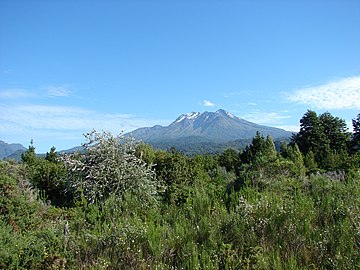
 Calbuco viewed from the north alongside Road 225 on the shores of Llanquihue Lake. (February 11, 2010) | |
| Highest point | |
| Elevation | 2,015 m (6,611 ft)[1] |
| Prominence | 1,946 m (6,385 ft)[1] |
| Listing | Ultra |
| Coordinates | 41°19′48″S 72°37′06″W[1] |
| Geography | |
 Calbuco Chile | |
| Location | Los Lagos, Chile |
| Parent range | Andes |
| Geology | |
| Age of rock | Pleistocene |
| Mountain type | Stratovolcano |
| Volcanic arc/belt | South Volcanic Zone |
| Last eruption | April 2015 |
The most recent eruption, a major VEI 4 event,[2] happened with little warning on April 22–23, 2015, followed by a smaller eruption on April 30. This was Calbuco's first activity since 1972.[3][4][5]
Name and location
Calbuco is located partly in Puerto Varas Commune and partly in Puerto Montt Commune. It lies 49 km from the city of Puerto Varas and 69 km from Puerto Montt. Its name is thought to come from the Mapuche words "kallfü" (blue) and "ko" (water), meaning "blue water".[6] It shares the name with Calbuco Island in nearby Reloncaví Sound as well as the city and commune of Calbuco, although it is not located there.
Geology
Calbuco is a very explosive andesite volcano whose lavas usually contain 55 to 60% silicon dioxide (SiO2).[7] It is elongated in a SW-NE direction and is capped by a 400-500 meter wide summit crater. Its complex evolution included the collapse of an intermediate edifice during the late Pleistocene that produced a debris avalanche that reached Llanquihue Lake.[8]
Volcanic activity

Calbuco has had 36 confirmed eruptions during the Holocene, 13 of which have been recorded in historical times. 20th century eruptions took place in 1906, 1907, 1909, 1911, 1917, 1929, 1932, 1945, 1961, and 1972. A series of three eruptions occurred from April 22–30, 2015.[9]
The 1893–95 Calbuco eruption was one of the largest ever to take place in southern Chile, with debris ejected to distances of eight kilometres, accompanied by voluminous hot lahars.[citation needed] The 1893 eruption disrupted the daily life of German settlers in eastern Llanquihue Lake. In this area potato fields, cattle and apiculture was negatively impacted. Cattle were evacuated from the area and settlers lobbied the government of Jorge Montt to be relocated elsewhere.[10]
In the strong explosions of April 1917, a lava dome formed in the crater accompanied by hot lahars. Another short explosive eruption in January 1929 also included an apparent pyroclastic flow and a lava flow.[citation needed]
The major eruption of 1961 sent ash columns 12–15 km high, produced plumes that dispersed mainly to the south east and emitted two lava flows. There was a minor, four-hour eruption on August 26, 1972. Strong fumarolic emission from the main crater was observed on August 12, 1996.[8]
The most recent eruption happened in April 2015, when on April 22, the volcano suddenly erupted with little warning, sending a large ash column into the atmosphere; another eruption occurred in the early hours of April 23. A smaller eruption occurred on April 30. The eruptions ranked as a 4 on the Volcanic Explosivity Index.[3][4][5] The volcano returned to the lowest alert level on August 18, 2015.[11] The ash of the eruption dispersed nutrients into the sea which may have contributed to unleashing the algal bloom of 2016.[12]
See also
Gallery
 Calbuco viewed from the north alongside Road 225 on the shores of Llanquihue Lake (February 11, 2010).
 From Osorno volcano (July 28, 2006).
 View of the eruption column of Calbuco Volcano from Puerto Varas, Chile, on April 22, 2015.
 Picture taken with VIIRS, infrared, April 23, 2015.
- The ISS passes over a plume of ash and SO2 from the eruption.


References
- "Argentina and Chile: Central Ultra-Prominences". Peaklist.org. Retrieved July 7, 2013.
- "Calbuco: Eruptive History". Global Volcanism Program. Smithsonian Institution. Retrieved June 29, 2021.
- "Chile's Calbuco volcano erupts". The Guardian. April 22, 2015. Retrieved April 23, 2015.
- "Calbuco Volcano: second eruption leaves towns and villages covered in thick blankets of dust". The Daily Mirror. April 24, 2015. Retrieved May 6, 2015.
- "Chile's Calbuco volcano erupts again". The Guardian. April 30, 2015. Retrieved May 6, 2015.
- Calbuco: Aguas Azules Ellanquihue.cl, retrieved May 6, 2015
- "Calbuco: Latest Activity Reports". Global Volcanism Program. Smithsonian Institution. Retrieved June 29, 2021.
- "Calbuco: General Information". Global Volcanism Program. Smithsonian Institution. Retrieved June 29, 2021.
- "Eruptive History of Calbuco". Smithsonian Institution. Retrieved January 4, 2016.
- Petit-Breuilh Sepúlveda, María Eugenia (2004). La historia eruptiva de los volcanes hispanoamericanos (Siglos XVI al XX): El modelo chileno (in Spanish). Huelva, Spain: Casa de los volcanes. p. 59. ISBN 84-95938-32-4.
- "Global Volcanism Program - Report on Calbuco (Chile) — 19 August-25 August 2015". volcano.si.edu.
- "Inédita investigación reveló efectos del volcán Calbuco sobre los mares de la Patagonia". Qué Pasa (in Spanish). La Tercera. June 24, 2021. Retrieved June 24, 2021.
Sources
- González-Ferrán, Oscar (1995). Volcanes de Chile (in Spanish). Santiago, Chile: Instituto Geográfico Militar. p. 640 pp. ISBN 956-202-054-1.
- Biggar, John (2005). The Andes: A Guide for Climbers (3rd ed.). Andes Publishing (Scotland). p. 304 pp. ISBN 0-9536087-2-7.
External links
- "Volcán Calbuco, Chile" on Peakbagger
- Roja: Declina actividad del volcán Calbuco tras segunda erupción[permanent dead link] on Sernageomin (in Spanish)
- Se mantiene monitoreo permanente al volcán Calbuco on Onemi (in Spanish)
- Calbuco volcano description with photo gallery of its historical eruptions (in Spanish)
- Analysis of precursory activity of the 2015 eruption (in Spanish)
- First studies with results of the 2015 eruption (in Spanish)
- Videos 2015 Eruption
- Video Calbuco Volcano Erupts by National Geographic 2015-04-23
- Video Timelapse Calbuco Chile 2015-04-22 on YouTube
На других языках
[de] Calbuco (Vulkan)
Der Calbuco ist ein 2003 m hoher, aktiver Stratovulkan im kleinen Süden Chiles in der Region Los Lagos. Seine Ausläufer reichen bis an das Südufer des Lago Llanquihue und an das nordwestliche Ende des Chapo-Sees. Der Vulkan ist Teil des Llanquihue-Naturreservates.- [en] Calbuco (volcano)
[es] Volcán Calbuco
El volcán Calbuco es un volcán activo del sur de Chile, localizado al sureste del lago Llanquihue, en la Región de Los Lagos. Su ladera norte está dentro de la comuna de Puerto Varas y su ladera sur, en la de Puerto Montt. El volcán es de composición de andesita,[1] alcanza los 2003 msnm, y su silueta es visible desde Osorno hasta Chiloé. Es parte de la Reserva Nacional Llanquihue, y de sus laderas nace el río Pescado.[2][fr] Calbuco (volcan)
Le Calbuco est un volcan du Chili s'élevant au sud-est du lac Llanquihue, au nord-est de la ville de Puerto Montt et au nord-est du golfe du Seno de Reloncaví. Composé d'andésite et couvert à son sommet de glaciers, il culmine à 2 015 mètres d'altitude. Alors que sa dernière éruption remontait au 26 août 1972, il est, sans signe avant-coureur, brusquement entré en éruption le 22 avril 2015[1].[it] Monte Calbuco
Il Calbuco è uno stratovulcano attivo situato nel sud del Cile, a sud-est del Lago Llanquihue e a nord-ovest del Lago Chapo, nella Regione di Los Lagos.[ru] Кальбуко (вулкан)
Кальбуко (исп. Calbuco) — активный вулкан в Андах на территории Чили.Другой контент может иметь иную лицензию. Перед использованием материалов сайта WikiSort.org внимательно изучите правила лицензирования конкретных элементов наполнения сайта.
WikiSort.org - проект по пересортировке и дополнению контента Википедии