geo.wikisort.org - Mountains
Tungurahua (/tʊŋɡʊˈrɑːwə/; from Quichua tunguri (throat) and rahua (fire), "Throat of Fire")[5] is an active stratovolcano located in the Cordillera Oriental of Ecuador. The volcano gives its name to the province of Tungurahua. Volcanic activity restarted on August 19, 1999,[6] and is ongoing as of 2013[update], with several major eruptions since then, the last starting on 1 February 2014.[7][8]
This article needs to be updated. (October 2020) |
| Tungurahua | |
|---|---|
 View from Riobamba (September 2011) | |
| Highest point | |
| Elevation | 5,023 m (16,480 ft)[1] |
| Prominence | 1,554 m (5,098 ft) |
| Listing | Ultra |
| Coordinates | 1.4700°S 78.4447°W[2] |
| Naming | |
| English translation | Throat of fire |
| Language of name | Quechua |
| Geography | |
| Location | Ecuador |
| Parent range | Cordillera Oriental, Andes |
| Topo map | IGM, CT-ÑIV-D1[3] |
| Geology | |
| Age of rock | Holocene (Gomez 1994) |
| Mountain type | Stratovolcano (active) |
| Volcanic arc/belt | Northern Volcanic Zone |
| Last eruption | 2000 to 2018 (ongoing)[4] |
| Climbing | |
| First ascent | 1873 by Alphons Stübel and Wilhelm Reiss |
| Easiest route | Scrambling/Snow/Ice PD |
Etymology
According to one theory the name Tungurahua is a combination of the Quichua tunguri (throat) and rahua (fire) meaning "Throat of Fire".[5] According to another theory it is based on the Quichua uraua for crater.[9] Tungurahua is also known as "The Black Giant", and in local indigenous mythology it is allegedly referred to as Mama Tungurahua ("Mother Tungurahua").
Geography and geology

Location
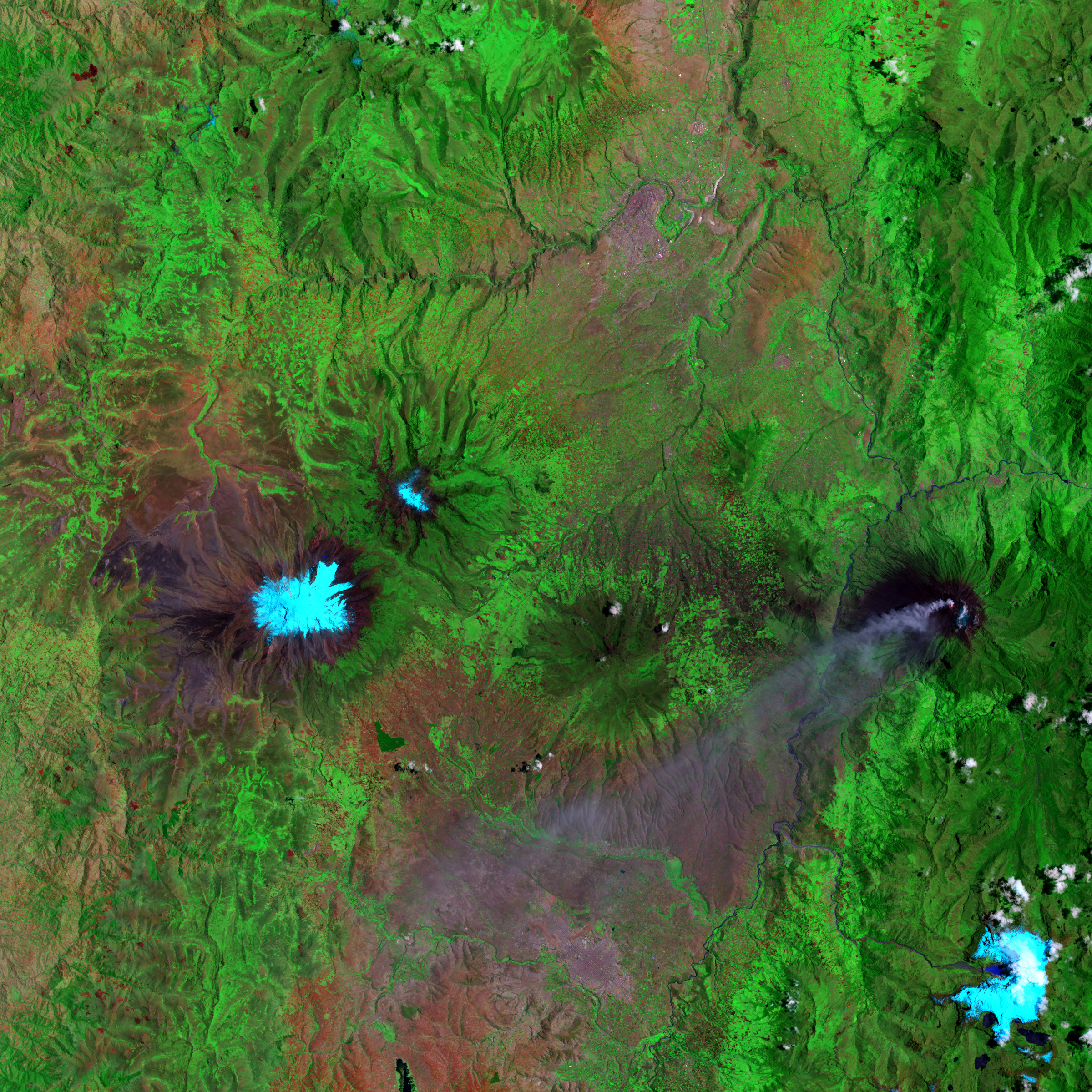
Tungurahua 5,023 metres (16,480 ft) is located in the Cordillera Oriental of the Andes of central Ecuador, 140 kilometres (87 mi) south of the capital Quito. Nearby notable mountains are Chimborazo (6,263 metres (20,548 ft)) and El Altar (5,319 metres (17,451 ft)). It rises above the small thermal springs town of Baños de Agua Santa (1,800 metres (5,900 ft)) which is located at its foot 8 kilometres (5.0 mi) to the north. Other nearby towns are Ambato (30 kilometres (19 mi) to the northwest), Baños and Riobamba (30 kilometres (19 mi) to the southwest). Tungurahua is part of the Sangay National Park.
Glacier
With its elevation of 5,023 metres (16,480 ft), Tungurahua just over tops the snow line (about 4,900 metres (16,100 ft)). Tungurahua's top is snow-covered and did feature a small summit glacier which melted away after the increase of volcanic activity in 1999.
Volcanism
Today's volcanic edifice (Tungurahua III) is constructed inside its predecessor's (Tungurahua II) caldera which collapsed about 3000 (±90) years ago. The original edifice (Tungurahua I) collapsed at the end of the Late Pleistocene.[10]
Historical volcanic activity
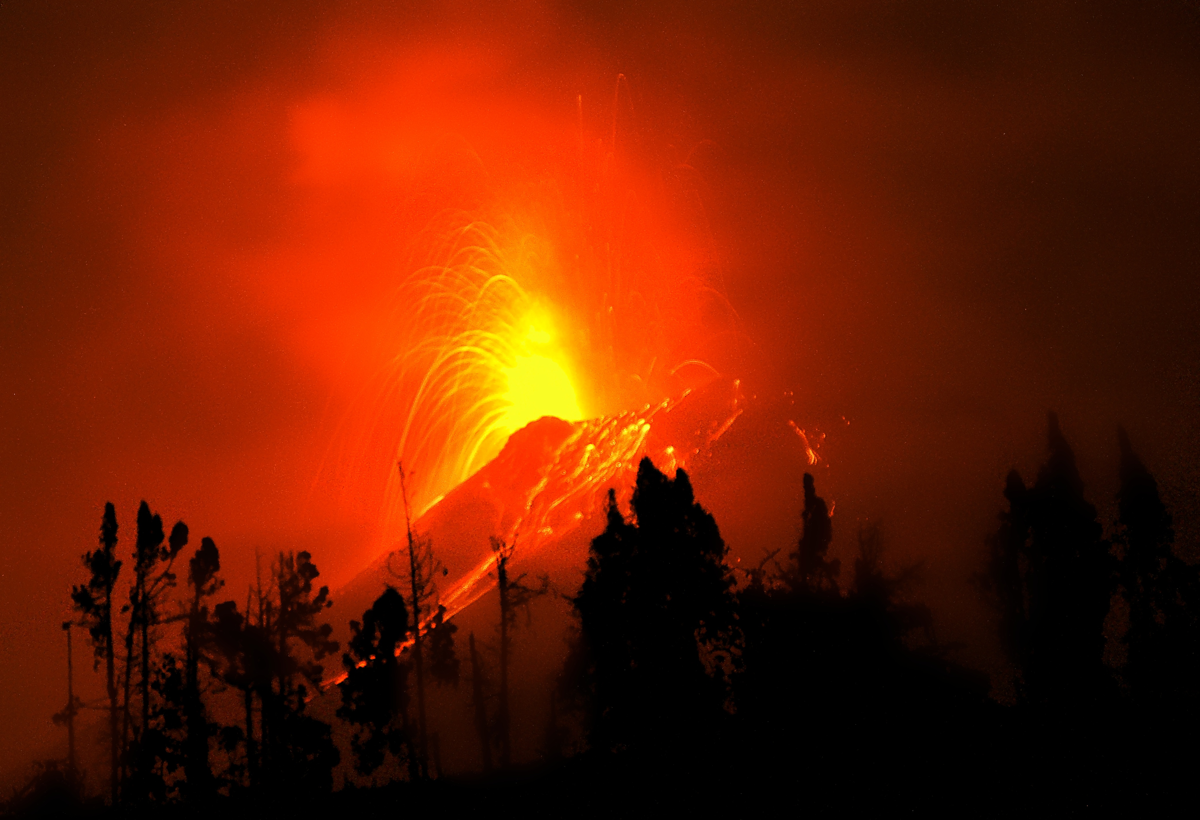
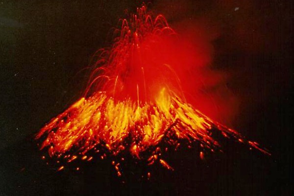
Tungurahua's eruptions are strombolian. They produce andesite and dacite. All historical eruptions originated from the summit crater and have been accompanied by strong explosions, pyroclastic flows and sometimes lava flows. In the last 1,300 years Tungurahua entered every 80 to 100 years into an activity phase of which the major have been the ones of 1773, 1886 and 1916–1918.[11]
Study of volcanic ash layers deposited in the lakes of El Cajas National Park show that there were major eruptions 3,034±621, 2,027±41, 1,557±177, 733±112 years ago (cal BP).[12]
Recent volcanic activity
In 2000, after a long period of quiescence, the volcano entered an eruptive phase that continues to this day (as of April 2014[update]). The renewed activity in October 1999 produced major ashfall and led to the temporary evacuation of more than 25,000 inhabitants from Baños and the surrounding area[13] Activity continued at a medium level until May 2006, when activity increased dramatically, culminating in violent eruptions on 14 July 2006 and 16 August 2006. The 16 August 2006 eruption has been the most violent since activity commenced in 1999. This eruption was accompanied by a 10 kilometres (6.2 mi) high ash plume which spread over an area of 740 by 180 kilometres (460 by 110 mi),[14] depositing ash and tephra to the southwest of the volcano. Several pyroclastic flows were generated that killed at least five people, and destroyed a number of hamlets and roads on the eastern and northwestern slopes of the volcano.[15]
A further eruption and evacuation occurred on 4 December 2010. Ecuador's National Agency of Risk Control issued a "red alert", later downgraded to orange.[16] The Ecuadorean Institute for Geophysics reported a rapid increase in seismic activity, a number of explosions and an ash cloud reaching 2 kilometres (1.2 mi) in height.[17] Another eruption occurred on 18 December 2012 forcing evacuation of those living on the volcano's slopes.[18] The volcano erupted again in July 2013,[19][20] and again on 1 February 2014.
|

First ascent
In June 1802, the Prussian-born explorer Alexander von Humboldt tried without success to reach the summit.[21] During their seven-year-long South America expedition (1868 to 1876), the German volcanologists Alphons Stübel and Wilhelm Reiss climbed Cotopaxi (Reiss with Angel Escobar; 28 November 1872) and Tungurahua (Stübel with Eusebio Rodríguez; 9 February 1873).[9]

See also
- Lists of volcanoes
- List of volcanoes in Ecuador
- List of stratovolcanoes
References
- Several elevation data between 5,016 and 5,029 m are used, 5,023 m is the one used on IGM maps. Used extremes are: 5,087 m (Stübel 1897) and 5,005 m (Neate 1994).
- "Tungurahua". Global Volcanism Program. Smithsonian Institution. Retrieved 2009-01-01.
- IGM (Instituto Geografico Militar, Ecuador) (1989). "Baños Ecuador, CT-ÑIV-D1". Archived from the original on 2008-12-19. Retrieved 2008-01-26.
- "Tungurahua volcano". 19 Feb 2018.
- "In the shadow of the Tungurahua volcano". BBC News. 7 September 2006.)
- "Tungurahua volcano erupts in Ecuador". NBC News. 19 Aug 2012.
- "Ecuador's Tungurahua Volcano shoots ash and lava". Associated Press. 2014-02-01.
- https://www.nytimes.com/2015/08/25/science/mount-tambora-volcano-eruption-1815.html?_r=0 A Volcanic Eruption That Reverberates 200 Years Later
- Schmudlach, Günter (2001). Bergführer Ecuador. Panico Alpinverlag. ISBN 3-926807-82-2.
- "Geología". Volcán Tungurahua. IGEPN. Archived from the original on 2006-01-16.
- "Historia". Volcán Tungurahua. IGEPN. Archived from the original on 2005-12-16.
- Arcusa, Stéphanie H.; Schneider, Tobias; Mosquera, Pablo V.; Vogel, Hendrik; Kaufman, Darrell; Szidat, Sönke; Grosjean, Martin (2020). "Late Holocene tephrostratigraphy from Cajas National Park, southern Ecuador". Andean Geology. 47 (3): 508–528. doi:10.5027/andgeoV47n3-3301.
- "Ecuadoreans Wait Uneasily On Volcanoes". New York Times. 1999-11-28.
- "Volcán Tungurahua - Ecuador". IGEPN. Archived from the original on 2005-09-07.
- Kramer, Jack (2006-08-16). "Volcano Erupts". National Ledger.
- CNN Wire Staff (5 December 2010). "Volcano known as the 'Throat of Fire' erupts in Ecuador". CNN Wire. Retrieved 5 December 2010.
- "Tungurahua volcano prompts evacuation in Ecuador". BBC News. 4 December 2010.
- "Ecuador's Tungurahua volcano threatens local villages". BBC News. 18 December 2012.
- "Tungurahua volcano in Ecuador spews huge ash plume forcing hundreds from their homes". Daily Telegraph. 15 July 2013. Retrieved 15 July 2013.
- "Eruption of the Tungurahua volcano in Ecuador". CIMSS Satellite Blog. 14 July 2013.
- Daum, Andreas (2019). Alexander von Humboldt. Munich: C. H. Beck. pp. 56‒57. ISBN 978-3-406-73436-6.
Further reading
- Gómez, Nelson (1994). Atlas del Ecuador. Editorial Ediguias. ISBN 9978-89-009-2.
- IG-EPN (Instituto Geofisico Escuela Politecnica Nacional, Ecuador). "Tungurahua". Archived from the original on 2006-08-24. Retrieved 2006-08-18.
- Neate, Jill (1994). Mountaineering in the Andes. Expedition Advisory Centre. ISBN 0-907649-64-5.
- Ruiz, M; et al. (2006). "Source constraints of Tungurahua volcano explosion events". Bulletin of Volcanology. Springer-Verlag. 68 (5): 480–490. doi:10.1007/s00445-005-0023-8. S2CID 129877389.
External links
 Media related to Tungurahua at Wikimedia Commons
- (in Spanish) Instituto Geofisico del Ecuador
- Climbing information for Tungurahua on summitpost.org
- Banos Ecuador Weather | Daily Report
Authority control | |
|---|---|
| General | |
| National libraries | |
На других языках
[de] Tungurahua
Der Tungurahua ist ein aktiver Schichtvulkan, der südöstlich von Ambato am Ostabhang der Anden Ecuadors liegt und das Amazonasgebiet überragt. Der Name stammt wahrscheinlich aus dem Quechua von tunguri = Schlund, rahua = brennen, feuerspeien.- [en] Tungurahua
[es] Volcán Tungurahua
El Tungurahua es un estratovolcán activo situado en la zona andina de Ecuador. El volcán se alza en la Cordillera Oriental de Ecuador, límite de las provincias de Chimborazo y Tungurahua, y da nombre a esta última. Está frecuentemente en erupción, las últimas más violentas han tenido lugar el 14 de julio de 2006, 16 de agosto de 2006, 28 de mayo de 2008, 26 de abril de 2010, 20 de agosto de 2012, el 1 de febrero de 2014 y la más reciente el 27 de febrero de 2016. El Instituto Geofísico, EPN monitorea la actividad del volcán Tungurahua y otros volcanes en las montañas de los Andes de Ecuador y en las Islas Galápagos.[1][2][fr] Tungurahua
Le Tungurahua est un stratovolcan équatorien en activité de 5 023 mètres d'altitude, situé à cheval entre les provinces de Chimborazo et Tungurahua. En éruption depuis le 5 octobre 1999, son activité éruptive a repris le 28 mai 2010 et connaît à partir du 26 avril 2011 une nouvelle phase explosive.[it] Tungurahua
Il Tungurahua (5023 m s.l.m.) è uno stratovulcano andino dell'Ecuador, localizzato nell'omonima provincia. Si tratta di uno dei più attivi tra i numerosi vulcani presenti nel territorio ecuadoriano. Il suo nome significa "gola ardente" (o gola di fuoco) nella lingua quechua.[1][ru] Тунгурауа
Тунгурауа (исп. Tungurahua, от кечуа Tunguri — «горло» и rahua — «огонь», то есть «огненное горло») — действующий вулкан в Эквадорских Андах (Кордильера-Реаль[en]), на территории национального парка Сангай. По названию вулкана названа и провинция Тунгурауа, на территории которой он расположен. Абсолютная высота вулкана 5023 метра над уровнем моря.Другой контент может иметь иную лицензию. Перед использованием материалов сайта WikiSort.org внимательно изучите правила лицензирования конкретных элементов наполнения сайта.
WikiSort.org - проект по пересортировке и дополнению контента Википедии