geo.wikisort.org - Mountains
Chaitén is a volcanic caldera 3 kilometres (2 mi) in diameter, 17 kilometres (11 mi) west of the elongated ice-capped Michinmahuida volcano and 10 kilometres (6 mi) northeast of the town of Chaitén, near the Gulf of Corcovado in southern Chile. The most recent eruptive phase of the volcano erupted on 2008. Originally, radiocarbon dating of older tephra from the volcano suggested that its last previous eruption was in 7420 BC ± 75 years. However, recent studies have found that the volcano is more active than thought. According to the Global Volcanism Program, its last eruption was in 2011.[1]
| Chaitén | |
|---|---|
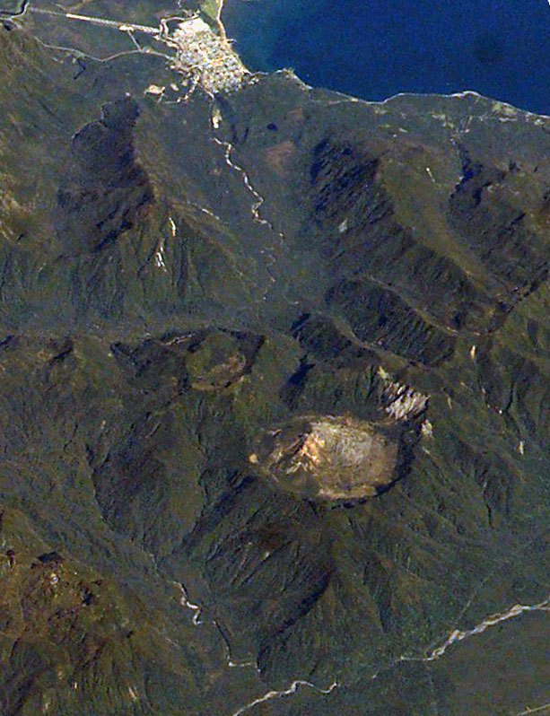 2003 photograph from the International Space Station. The caldera is the circular feature visible in the lower part of the image. The town of Chaitén is to the top. (This image is aligned roughly southwest, around 220°.) | |
| Highest point | |
| Elevation | 1,122 m (3,681 ft) |
| Coordinates | 42°50′14″S 72°38′53″W |
| Geography | |
 Chaitén Location of Chaitén in Chile | |
| Location | 10 kilometres (6 mi) northeast of Chaitén, Palena Province, Los Lagos Region, Chile |
| Parent range | Andes |
| Geology | |
| Mountain type | Caldera |
| Volcanic belt | South Volcanic Zone |
| Last eruption | 2008 to 2011 |
The caldera rim reaches 1,122 metres (3,681 ft) above sea level. Before the current eruption, it was mostly filled by a rhyolite obsidian lava dome that reached a height of 962 metres (3,156 ft), partly devoid of vegetation. Two small lakes occupied the caldera floor on the west and north sides of the lava dome.[1]
The translucent grey obsidian which had erupted from the volcano was used by pre-Columbian cultures as a raw material for artifacts and has been found as far away as 400 kilometres (250 mi) to the south and north, for example in Chan-Chan.[2][3]
2008 eruption
The Chaitén volcano entered a new eruptive phase for the first time since around 1640 on the morning of May 3, 2008.[1] The Chilean government began an evacuation of the nearby town of Chaitén (population 4,200) and the surrounding area the same day, the main phase of which was completed by May 3, 2008.[4] One elderly person died while at sea en route to Puerto Montt.[5][6] By the afternoon of May 3, the plume of ash from the eruption had spread across Chile and Argentina to the Atlantic Ocean, contaminating water supplies, and reportedly coating the town of Futaleufú located 75 kilometres (47 mi) southeast to a depth of 30 centimetres (12 in).[5][7] Ash thickness estimates are often exaggerated during volcanic crises; later field investigations suggest that the average ash thickness deposited across Futaleufú was less than 5–10 cm (2–4 in).[8]

A team of scientists from the US was dispatched to the area to assess the air quality and the risks from chemicals in the falling ash.[5]

The initial phase of the actual eruption in 2008 was characterised by ash emissions and seismic activity; local seismic measurements in 2005 registered earthquakes up to magnitude 3.6 MW below the Chaitén volcano.[9] On May 6, 2008, the force of eruption increased significantly, producing pyroclastic flows and possibly some lava explosions, and raising the eruption column to a height of perhaps 30,000 metres (98,000 ft).[10] The remaining personnel and almost all inhabitants of Chaitén and nearby villages were evacuated,[11] as was Futaleufú.[12]

In the early phase of the eruption (May 2, 2008), two separate vents had developed in the old lava dome. An overflight on May 6, 2008, found that these had fused into one vent roughly 800 metres (2,600 ft) across. OVDAS warned of possible major pyroclastic incidents, and the likelihood of prolonged activity.[13]
On May 8, 2008, the government said it would force the last residents from the danger area, but this was later legally challenged by some residents and left to no effect by the Supreme Court.[14][15] Government personnel later returned to attend to livestock and rescue dogs and other animals.[16][17]
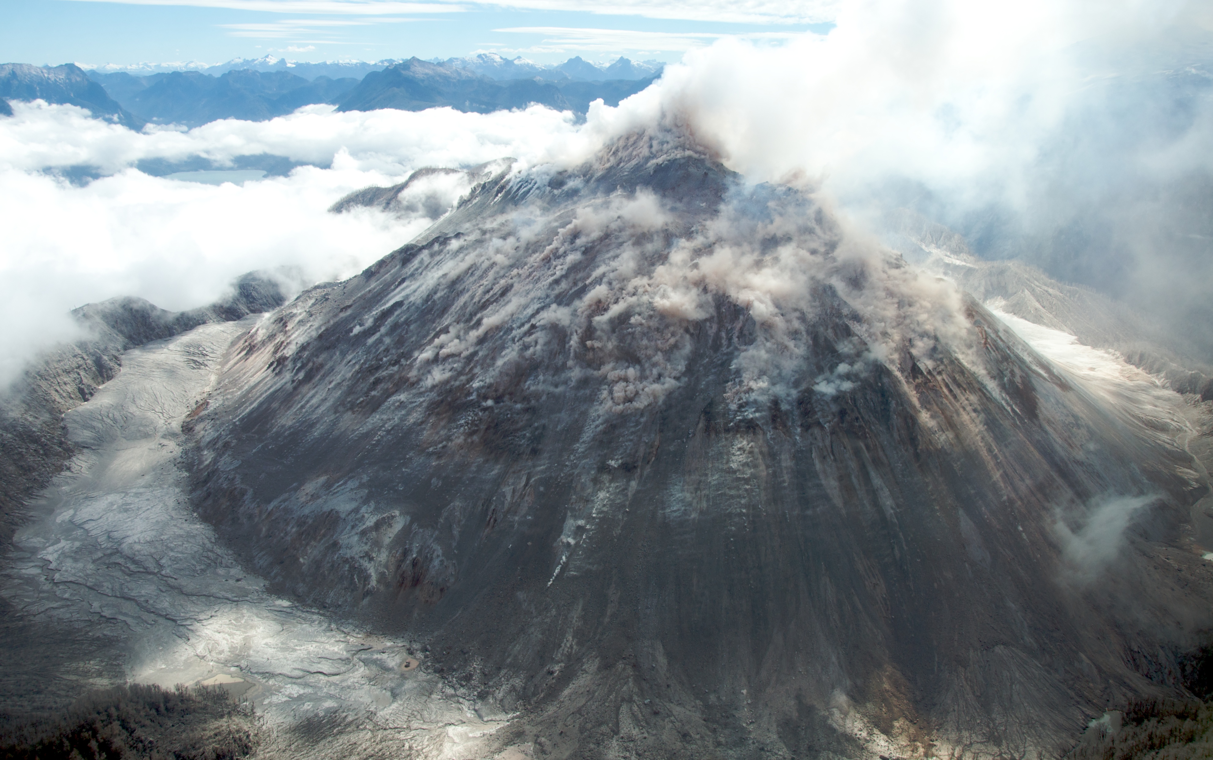
Through the remainder of May and June 2008 the eruption continued as a variable but gradually decreasing emission of ash, with intermittent seismic activity and pyroclastic flows. On May 21, a new lava dome was observed to be forming in the crater,[1] which by May 24 exceeded the height of the old dome.[18] Initially, the dome extended towards the north side of the caldera,[19] but following the emergence of two new vents in the south of the old dome around June 11[20] and a later one to the west, the expansion moved to the south, eventually blocking the drainage from the caldera floor.[1][21][22]
As of July 3, 2008, Chaitén continued to erupt, with associated seismic activity, an eruptive column of ash up to 3,000 metres (9,800 ft), and a growing lava dome.[22] Whether the dome will be stable remains uncertain, and there is an ongoing risk of collapse and explosive pyroclastic eruption.[23] In August 2008, an expedition reached the summit of Chaiten volcano. The summit crater contained a 120 metres (390 ft) high lava dome. Earthquakes were felt at the summit. The lava dome was loudly degassing, and avalanches of lava boulders fell from the dome side to the crater floor.
On February 19, 2009, a partial dome collapse caused pyroclastic flows to descend through the Chaitén river valley reaching down to approximately 5 kilometres (3 mi) from the town of Chaitén.[24] The ash once again reached Futaleufú and parts of Chubut province in neighboring Argentina. The approximately 160 people that were in Chaitén were strongly urged to leave, and all but 25 people who refused to leave were evacuated that day.[25]
Damage
Forests near the volcano have been burned by pyroclastic flows and lateral explosions.[26] Large parts of southern Argentina and Chile have been coated with ash, with possible longer term consequences for agriculture, although not only negative as ash adds new minerals to the soil. Large amounts of ash have fallen in some areas, posing a risk of lahars for several communities.[citation needed]
Beginning on May 12, lahars caused flooding in the town of Chaitén,[27] depositing ash mud to a depth of up to a metre or more, damaging many buildings, and completely filling the original course of the Chaitén River past the town. Over the subsequent weeks, the river excavated a new course through Chaitén, completely destroying a significant part of it by July 2008. Some defensive work has been undertaken by the government. There were plans to move town some 10 kilometres (6 mi) north but these have not been concluded as yet. The town of Chaiten is slowly recovering. Its current population is about 900 people.[citation needed]
Rarity
This eruption is known as the first major explosive eruption of rhyolite magma in nearly a century, since the 1912 eruption of Novarupta, in Alaska.[8] Although there have been rhyolitic eruptions in the southern section of the Southern Volcanic Zone in the past, these are relatively scarce and there is no historic rhyolitic eruption of the magnitude of Chaitén.[citation needed]

References
- "Chaitén". Global Volcanism Program. Smithsonian Institution. Retrieved May 2, 2018.
- Naranjo, José A; Stern, Charles R (December 2004). "Holocene tephrochronology of the southernmost part (42°30'-45°S) of the Andean Southern Volcanic Zone". Revista Geológica de Chile. 31 (2): 225–240. doi:10.4067/S0716-02082004000200003. ISSN 0716-0208. OCLC 61022562.
- (in Spanish) Pino, Mario and Navarro, Rayen. Geoarqueología del sitio arcaico Chan-Chan 18. Revista Geológica de Chile, 2005.
- "MINISTRO DEL INTERIOR EN CHAITÉN: "ES UN ÉXITO SIN PRECEDENTES HABER EVACUADO EN 24 HORAS A CUATRO MIL PERSONAS"" (Press release) (in Spanish). ONEMI. May 3, 2008. Archived from the original on June 11, 2008. Retrieved July 9, 2008.
- Malinowski, Matt (May 5, 2008). "Evacuations continue in Chile volcano zone". Patagonia Times. Archived from the original on May 9, 2008. Retrieved May 13, 2008.
- "One dead as Chilean volcano spews ash for third day". Reuters UK. Thomson Reuters. May 4, 2008. Retrieved May 13, 2008.
- "Informe Nª- 248 04/05/08- Actividad Volcánica (Actualiza Información)" (Press release) (in Spanish). ONEMI. May 4, 2008. Archived from the original on June 11, 2008. Retrieved July 9, 2008.
- Watt, S.F.L.; Pyle, D.M.; Mather, T.A.; Martin, R.S.; Matthews, N.E. (2009). "Fallout and distribution of volcanic ash over Argentina following the May 2008 explosive eruption of Chaiten, Chile". Journal of Geophysical Research. 114 (B04207). Bibcode:2009JGRB..11404207W. doi:10.1029/2008JB006219. S2CID 53137424.
- Lange, D.; Cembrano, J.; Rietbrock, A.; Haberland, C.; Dahm, T.; Bataille, K. (April 2008). "First seismic record for intra-arc strike-slip tectonics along the Liquiñe-Ofqui fault zone at the obliquely convergent plate margin of the southern Andes". Tectonophysics. 455 (1–4): 14–24. Bibcode:2008Tectp.455...14L. doi:10.1016/j.tecto.2008.04.014. hdl:10533/139825.
- "Informe N°252 06/05/08 - Se activan todos los operativos de evacuación en Chaitén" (Press release) (in Spanish). ONEMI. May 6, 2008. Archived from the original on December 26, 2008. Retrieved July 9, 2008.
- "Informe N°251 06/05/08 Se evacua de manera preventiva totalidad de personas en Chaitén" (Press release) (in Spanish). ONEMI. May 6, 2008. Archived from the original on December 26, 2008. Retrieved July 9, 2008.
- "Chile eruption spurs evacuations". BBC News. BBC. May 6, 2008. Retrieved May 13, 2008.
- "Informa Sobre Erupción del Volcán Chaitén" (Press release) (in Spanish). SERNAGEOMIN. May 6, 2008. Retrieved July 9, 2008.
- "Alcalde acusó "irresponsabilidad" de la Suprema por visar regreso a Chaitén". Cooperativa.cl. July 11, 2008. Retrieved May 2, 2013.
- "Chile gives volcano holdouts ultimatum to flee" (Press release). Reuters. May 8, 2008. Retrieved July 9, 2008.
- "Chile Evacuates as Volcano Ash Reaches Buenos Aires". Bloomberg. May 7, 2008. Retrieved July 10, 2008.
- "Carabineros continúa rescate de mascotas en Chaitén" (in Spanish). La Nación. May 28, 2008. Retrieved July 10, 2008.
- "Actividad Eruptiva del Volcán Chaitén ha Decaído al Tipo Subpliniano" (Press release) (in Spanish). SERNAGEOMIN. May 26, 2008. Retrieved July 10, 2008.
- "Informa Acerca de Actividad Eruptiva del volcán Chaitén" (Press release) (in Spanish). SERNAGEOMIN. May 22, 2008. Retrieved July 10, 2008.
- "Volcán Chaitén Presentó Aumento de Actividad Eruptiva" (Press release) (in Spanish). SERNAGEOMIN. June 13, 2008.
- "Informa Acerca de Actividad Eruptiva del Volcán Chaitén" (Press release) (in Spanish). SERNAGEOMIN. June 22, 2008. Retrieved July 10, 2008.
- "informa sobre el volcán Chaitén" (Press release) (in Spanish). SERNAGEOMIN. July 3, 2008. Retrieved July 11, 2008.
- "Informa acerca del Volcán Chaitén" (Press release) (in Spanish). SERNAGEOMIN. June 27, 2008. Retrieved July 11, 2008.
- "19.02.2009 Erupción del Volcán Chaitén Informe Especial" (Press release) (in Spanish). SERNAGEOMIN. February 19, 2009.
- "19/02/09 Chaitén: Informe consolidado del día" (Press release) (in Spanish). ONEMI. February 19, 2009. Archived from the original on July 7, 2011.
- "Informa acerca del Volcán Chaitén" (Press release) (in Spanish). SERNAGEOMIN. June 5, 2008. Retrieved July 10, 2008.
- "Informe N° 270 12/05/08 Actividad Volcán Chaitén (Actualiza Información)" (Press release) (in Spanish). ONEMI. May 12, 2008. Archived from the original on June 16, 2008. Retrieved July 10, 2008.
External links
Articles
- BBC News: In pictures: Chile volcano erupts
- Chaiten Volcano Still Active - The Big Picture - Boston.com
- Dagbladet: Vulkanen blir sintere (in Norwegian)
- SERNAGEOMIN (in Spanish)
- TerraDaily: Chilean volcano turns Chaiten into ghost town
- The Volcanism Blog - Chaitén
- Chaiten Volcano - John Seach
- The story of how Chaitén volcano was discovered (in Spanish)
Scientific Papers on the Chaitén eruption
- A Folch et al., 2008, Volcanic ash forecast – application to the May 2008 Chaitén eruption, Nat. Hazards Earth Syst. Sci., 8, 927-940
- LE Lara, 2009, The 2008 eruption of the Chaitén volcano: a preliminary report, Andean Geology 36, 125-129
- SFL Watt et al., 2009, Fallout and distribution of volcanic ash over Argentina following the May 2008 explosive eruption of Chaiten, Chile, Journal of Geophysical Research (Solid Earth) 114, B04207
- M Reich et al., 2009, Formation of cristobalite nanofibers during explosive volcanic eruptions, Geology 37, 435-438
Photography
- BBC, November 1, 2008, Alert at smoking Chile volcano
- Images and videos of current eruption (in Spanish)
- Region de los Lagos regional government photographs of the emergency. (in Spanish)
- Image gallery (in Spanish)
Webcams
- Chaitén caldera webcam (Southern Andean Volcano Observatory)
На других языках
[de] Chaitén (Vulkan)
Der Chaitén ist ein 1122 m hoher Vulkan in den Anden Patagoniens im Süden von Chile. Er liegt zehn Kilometer nordöstlich des kleinen gleichnamigen Küstenortes Chaitén in der vulkanisch sehr aktiven Gegend der Südamerikanischen Kordilleren. Seine Gipfelcaldera weist einen maximalen Durchmesser von 3,53 Kilometern auf und ist nahezu vollständig mit aus den Gesteinen Rhyolith und Obsidian bestehenden Lavadomen aufgefüllt. Diese Dome erreichten bis zum Ausbruch 2008 eine Höhe von 962 Metern über dem Meeresspiegel und waren teilweise mit Vegetation bewachsen. Innerhalb der Caldera am Rande der Lavadome befanden sich zudem zwei kleine Seen, einer an der West- und einer an der Nordseite.- [en] Chaitén (volcano)
[es] Volcán Chaitén
El volcán Chaitén es un volcán chileno del tipo caldera ubicado a 10 km al noreste de la ciudad de Chaitén, capital de la Provincia de Palena, en la Región de Los Lagos.[fr] Chaitén (volcan)
Le Chaitén est un volcan du sud du Chili constitué d'une caldeira dans laquelle s'inscrit un dôme de lave. Peu élevé comparativement aux volcans voisins Michinmahuida et Corcovado, il est dépourvu de glacier. Alors considéré comme éteint, il entre en éruption à partir de mai 2008 et détruit la ville voisine de Chaitén, forçant ses habitants à évacuer dans une nouvelle ville construite un peu plus loin.[it] Monte Chaitén
Il monte Chaitén è un vulcano del sud del Cile nella provincia di Palena, all'estremo nord della Patagonia cilena.[ru] Чайтен (вулкан)
Чайтен (исп. Volcán Chaitén) — активный вулкан в Чили.Другой контент может иметь иную лицензию. Перед использованием материалов сайта WikiSort.org внимательно изучите правила лицензирования конкретных элементов наполнения сайта.
WikiSort.org - проект по пересортировке и дополнению контента Википедии