geo.wikisort.org - Mountains
Pichincha is a stratovolcano in Ecuador. The capital Quito wraps around its eastern slopes.
| Pichincha | |
|---|---|
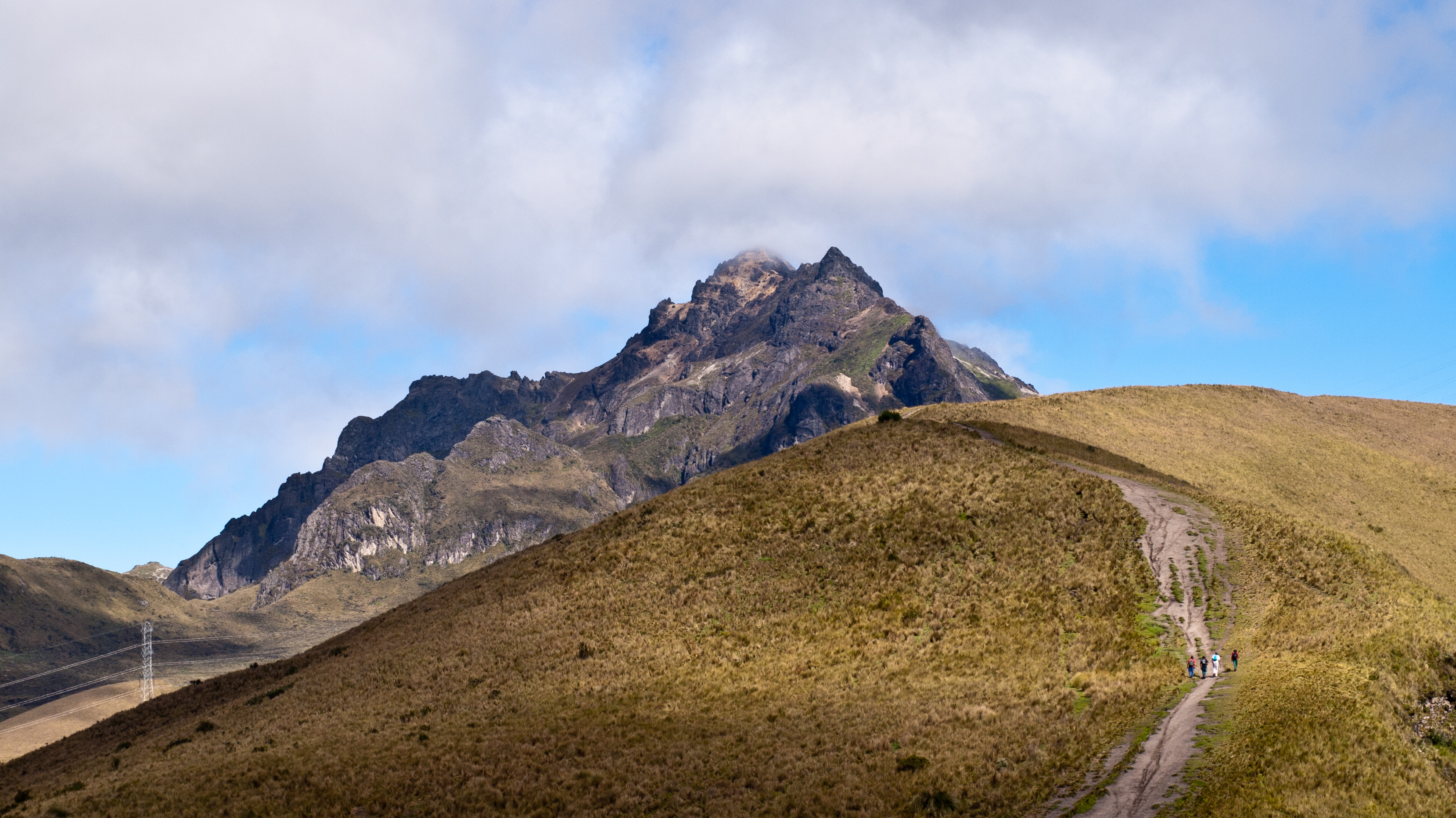 Ruku Pichincha as seen from the trail from Quito to the top | |
| Highest point | |
| Elevation | 4,784 m (15,696 ft) |
| Prominence | 1,652 m (5,420 ft) |
| Listing | Ultra |
| Coordinates | 0°10′16″S 78°35′53″W |
| Geography | |
 Pichincha Quito, Pichincha, Ecuador | |
| Parent range | Andes |
| Geology | |
| Age of rock | Quaternary |
| Mountain type | Stratovolcano |
| Volcanic arc/belt | North Volcanic Zone |
| Last eruption | October to December 2002[1] |
| Climbing | |
| First ascent | 1582 by José Ortiguera and others (first recorded ascent of Guagua Pichincha).[2] |
The two highest peaks of the mountain are Wawa Pichincha (Kichwa wawa child, baby / small,[3] Spanish spelling Guagua Pichincha) (4,784 metres (15,696 ft)) and Ruku Pichincha (Kichwa ruku old person,[3] Spanish Rucu Pichincha) (4,698 metres (15,413 ft)). The active caldera is in Wawa Pichincha on the western side of the mountain.[4]
Description
Both peaks are visible from the city of Quito and both are popular acclimatization climbs. Wawa Pichincha is usually accessed from the village of Lloa outside of Quito. Ruku is typically accessed from the TelefériQo on the western side of Quito.
In October 1999, the volcano erupted and covered the city with several inches of ash. Before that, the last major eruptions were in 1553[5] and in 1660, when about 30 cm (12 in) of ash fell on the city.
The province in which it is located was named for the mountain. This is also the case for many of the other provinces in Ecuador (including Cotopaxi, Chimborazo, and Imbabura).
Geography and geology
This section is empty. You can help by adding to it. (February 2016) |
Eruptions
In 1660, Pichincha underwent a Plinian eruption,[6] spreading ash over 1,000 kilometres (621 mi), with over 30 centimetres (12 in) of ash falling on Quito.[1]
The most recent significant eruption began in August 1998.[1] On March 12, 2000, a phreatic eruption killed two volcanologists who were working on the lava dome.[7]
History
The volcano was considered sacred to numerous cultures of the indigenous peoples who lived in this region for thousands of years before encounter with Spanish and other Europeans.
The first recorded ascent of Guagua Pichincha was in 1582 by a group of locals led by José Ortiguera.[2]
In 1737 several members of the French Geodesic Mission to the equator, including Charles-Marie de La Condamine, Pierre Bouguer and Antonio de Ulloa, spent 23 days on the summit of Rucu Pichincha as part of their triangulation work to calculate the length of a degree of latitude.[8]
On 17 June 1742, during the same mission, La Condamine and Bouguer made an ascent of Guagua Pichincha and looked down into the crater of the volcano, which had last erupted in 1660. La Condamine compared what he saw to the underworld.[9]
In the summer season of 1802, Alexander von Humboldt climbed and measured the altitude of this mountain and several other volcanoes in the region.[10] Humboldt's writings inspired artist Frederic Edwin Church to visit and paint Pichincha and other Andean peaks.[11]
On May 24, 1822, General Sucre's southern campaign in the Spanish–American War of independence came to a climax when his forces defeated the Spanish colonial army on the southeast slopes of this volcano. The engagement, known as the Battle of Pichincha, secured the independence from Spain of the territories of present-day Ecuador.

See also
- Lists of volcanoes
- List of volcanoes in Ecuador
- List of stratovolcanoes
References
- "Guagua Pichincha". Global Volcanism Program. Smithsonian Institution.
- Rachowiecki, Rob; Wagenhauser, Betsy (1997). Climbing & Hiking in Ecuador (4th ed.). Bradt. p. 91. ISBN 1898323542.
- Fabián Potosí, C; et al. (2009). Kichwa Yachakukkunapa Shimiyuk Kamu, Runa Shimi - Mishu Shimi, Mishu Shimi - Runa Shimi (Kichwa-Spanish dictionary). Quito: Ministerio de Educación del Ecuador.
- Hall, Minard (1977). El Volcanismo en el Ecuador (in Spanish). Sección Nacional del Ecuador.
- Kington, John A. (2010). Climate and Weather. London: Harper Collins. ISBN 9780007185016.
- "Guagua Pichincha Volcano". Volcano Discovery. Retrieved 2018-04-19.
- "Guagua Pichincha Volcano". Volcano Live. Retrieved 2018-04-19.
- Ulloa, Antonio de (1806). A voyage to South America: describing at large the Spanish cities, towns, provinces, &c. on that extensive continent. John Stockdale, R. Faulder, Longman, Lackington and J. Harding. p. 214. Retrieved November 9, 2017.
- Ferreiro, Larrie (2011). Measure of the Earth: The Enlightenment Expedition that Reshaped Our World. Basic Books. p. 215.
- Wolf, Andrea (2015). The Invention of Nature. Vintage Books.
- Howat, John K. (2015). Frederic Church. New Haven: Yale University Press. p. 55. ISBN 9780300109887.
External links
- CVO Website - Ecuador Volcanoes and Volcanics
- Photographs of the Andes
- "Eruptions of Guagua Pichincha (1999)" NOAA Operational Significant Event Imagery
Authority control | |
|---|---|
| General |
|
| National libraries | |
На других языках
[de] Pichincha
Der Pichincha ist der „Hausberg“ von Quito, der Hauptstadt Ecuadors. Der aktive Vulkan besitzt zwei Gipfel, von denen der Rucu Pichincha (Quechua: alter Pichincha) (4696 m) wesentlich näher an der Stadt liegt als sein mit 4776 m etwas höherer Bruder Guagua Pichincha (Quechua: junger Pichincha), der ungefähr fünf Kilometer westlich liegt, von Quito aus aber nicht sichtbar ist. Letzterer war 1999 sehr aktiv und brachte der Stadt einen Ausbruch mit Ascheregen. Dieser Ausbruch brachte es mit sich, dass ein großer Teil des westlichen Kraterrandes, aber auch der südöstliche, ehemals höchste Kraterbereich abbrach. Auf Grund der geografischen Lage Quitos wird angenommen, dass eventuelle Lavaflüsse keine Gefahr für die Stadt bedeuten.- [en] Pichincha (volcano)
[es] Volcán Pichincha
El Macizo de los Pichinchas son un conjunto de cerros y volcanes de Ecuador, situado en la capital del país, Quito. Pertenecen a la Cordillera Occidental de los Andes Ecuatorianos. Sus principales volcanes son el Guagua Pichincha y el Ruco Pichincha.[fr] Guagua Pichincha
Le Guagua Pichincha est un volcan d'Équateur culminant à 4 776 mètres. Situé à une dizaine de kilomètres à l'ouest de la ville de Quito, il domine la capitale du pays.[it] Pichincha (vulcano)
Il Pichincha è uno stratovulcano attivo dell'Ecuador, la cui capitale Quito è situata alle sue falde, ad una distanza di 11 km.[ru] Пичинча (вулкан)
Пичинча — действующий вулкан, расположенный в Эквадоре, чьи восточные склоны огибают Эквадорскую столицу — древний город Кито. Провинция, в которой расположена Пичинча берёт своё название от названия горы и также называется Пичинча.Другой контент может иметь иную лицензию. Перед использованием материалов сайта WikiSort.org внимательно изучите правила лицензирования конкретных элементов наполнения сайта.
WikiSort.org - проект по пересортировке и дополнению контента Википедии