geo.wikisort.org - Mountains
Misti, also known as Putina[2] or Guagua Putina,[3] is a stratovolcano of andesite, dacite, and rhyolite[4] located in southern Peru near the city of Arequipa. With its seasonally snow-capped, symmetrical cone, Misti stands at 5,822 metres (19,101 ft) above sea level and lies between the Chachani massif (6,075 m or 19,931 ft) and Pichu Pichu volcano (5,669 m or 18,599 ft). Its last eruption was in 1985, 198 years after its previous documented eruption.[1]
| Misti | |
|---|---|
 | |
| Highest point | |
| Elevation | 5,822 m (19,101 ft)[1] |
| Prominence | 1,785 m (5,856 ft) |
| Listing | Ultra |
| Coordinates | 16°17′40″S 71°24′32″W[1] |
| Geography | |
 Misti Peru | |
| Location | Arequipa, Peru |
| Parent range | Andes |
| Geology | |
| Mountain type | Stratovolcano |
| Volcanic arc/belt | Central Volcanic Zone |
| Last eruption | 1985 |
Description
Misti has three concentric craters. Active fumaroles (volcanic gas vents) can be seen in the inner crater.[5] Near the inner crater, six Inca mummies and rare Inca artifacts were found in 1998 during a month-long excavation directed by archaeologists Johan Reinhard and Jose Antonio Chavez. These findings are currently stored at the Museo de Santuarios Andinos in Arequipa.[citation needed]
The volcano has two main climbing routes. The Pastores route starts at 3,300 metres (10,800 ft). Usually a camp is made at 4,500 metres (14,800 ft) at Nido de Aguilas. The Aguada Blanca route starts at 4,000 metres (13,100 ft) near the Aguada Blanca reservoir, and a camp is made at 4,800 metres (15,700 ft) at Monte Blanco (the camp is named after Mont Blanc, the summit of which is approximately the same elevation as the camp). Neither climbing route presents technical difficulties, but both are considered strenuous because of the steep loose sand slopes.[citation needed]
Surrounding area
A long history of eruptions from Misti and its neighboring volcanoes has caused the local soil to be extremely fertile, making the surrounding area one of the most agriculturally productive in Peru.[5] Locals also make extensive use of a white volcanic rock called sillar, which is strong but easily workable.[5] The city of Arequipa has a significant number of buildings constructed with sillar, resulting in the nickname la ciudad blanca ("the white city").[5]
Gallery
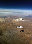 Aerial picture of Ubinas with Misti in the back (2015).
 Misti, as seen from Arequipa (2015).
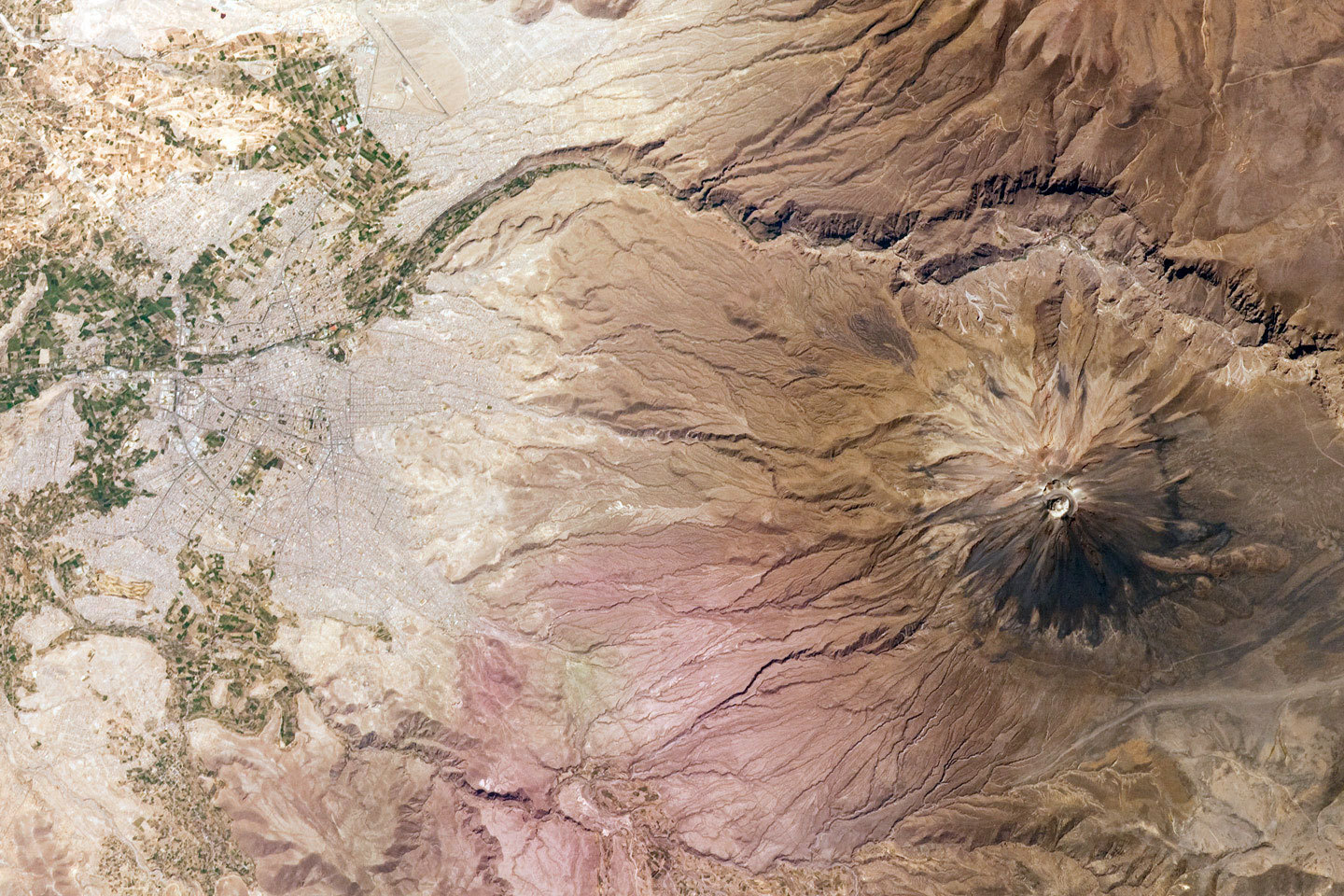
 This mosaic of two astronaut photographs taken from the ISS illustrates the proximity of Arequipa to Misti, just 17 km away (2009).
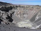 The crater of El Misti (2005).


See also
References
- "El Misti". Global Volcanism Program. Smithsonian Institution. Retrieved 2020-05-18.
- Thomas Besom. Of Summits and Sacrifice: An Ethnohistoric Study of Inka Religious Practices. University of Texas Press, 2009.
- "Global Volcanism Program | El Misti". volcano.si.edu. Retrieved 2017-08-16.
- Thouret, Jean-Claude; Finizola, Anthony; Fornari, Michel; Legeley-Padovani, Annick; Suni, Jaime; Frechen, Manfred (2001-12-01). "Geology of El Misti volcano near the city of Arequipa, Peru". GSA Bulletin. 113 (12): 1593–1610. doi:10.1130/0016-7606(2001)1132.0.CO;2. ISSN 0016-7606.
- Scheffel, Richard L.; Wernet, Susan J., eds. (1980). Natural Wonders of the World. United States of America: Reader's Digest Association, Inc. p. 251. ISBN 0-89577-087-3.
Bibliography
- Reinhard, Johan (2005). The Ice Maiden: Inca Mummies, Mountain Gods, and Sacred Sites in the Andes. Washington, D.C.: National Geographic Society. ISBN 0-7922-6838-5.
External links
- "El Misti Volcano and Arequipa, Peru". Earth Observatory. NASA. 2009-11-02. Retrieved 2016-06-03.
- "El Misti Volcano and the City of Arequipa, Peru". Earth Observatory. NASA. 2001-12-31. Retrieved 2016-06-03.
Authority control | |
|---|---|
| General | |
| National libraries | |
На других языках
[de] Misti
Der Misti ist ein Schichtvulkan im Süden von Peru in unmittelbarer Nähe der Stadt Arequipa. Der Vulkan beherrscht durch seine markante Kegelform das Stadtbild und gilt deswegen als Wahrzeichen von Arequipa, daher findet er sich im Stadtwappen wieder. Der 5822 Meter hohe Misti liegt zwischen zwei weiteren Vulkanen, dem 6057 Meter hohen Nevado Chachani und dem Picchu Picchu. Auf dem Gipfel des Misti wurde ein ca. 6 m hohes Kreuz aus Eisenschienen errichtet.- [en] Misti
[es] Misti
El Misti es un estratovolcán al sur del Perú, cerca de la ciudad de Arequipa, considerado como un volcán activo. Desde el año 2005 es monitoreado por el Observatorio Vulcanológico del INGEMMET y el Observatorio Vulcanológico del Sur (OVS) del Instituto Geofísico del Perú (IGP), el cual cuenta con seis estaciones sísmicas instaladas en su edificio volcánico y que registran las 24 horas del día los eventos sismovolcánicos producidos en su interior.[fr] Misti
Le Misti ou El Misti est un volcan du tronçon central de la cordillère des Andes au Pérou[2],[1]. Également connu sous le nom de Putina[3] ou Guagua Putina[4] ou San Francisco, c'est un stratovolcan d'andésite, de dacite et de rhyolite[5] situé dans le Sud du pays près de la ville d'Arequipa dans le département péruvien éponyme.[it] El Misti
El Misti, noto anche come “Guagua-Putina” è uno stratovulcano situato nel Perù meridionale, vicino alla città di Arequipa. Con la sua cima innevata in inverno e il cono simmetrico, El Misti spicca per 5.822 m sul livello del mare e giace tra il monte Chachani e il vulcano Pikchu Pikchu.[ru] Мисти (вулкан)
Ми́сти[2][3] (исп. El Misti) — вулкан в Южной Америке на территории южного Перу. Высота 5822 м, зимой вершина покрыта снегом.Другой контент может иметь иную лицензию. Перед использованием материалов сайта WikiSort.org внимательно изучите правила лицензирования конкретных элементов наполнения сайта.
WikiSort.org - проект по пересортировке и дополнению контента Википедии