geo.wikisort.org - Montagne
Le Quilotoa est un volcan d'Équateur culminant à 3 914 m, situé à une trentaine de kilomètres à l'ouest de Latacunga, capitale de la province de Cotopaxi. Il est situé au sud de la cordillère Occidentale.
Cet article est une ébauche concernant la montagne.
Vous pouvez partager vos connaissances en l’améliorant (comment ?) selon les recommandations des projets correspondants.
| Quilotoa | ||
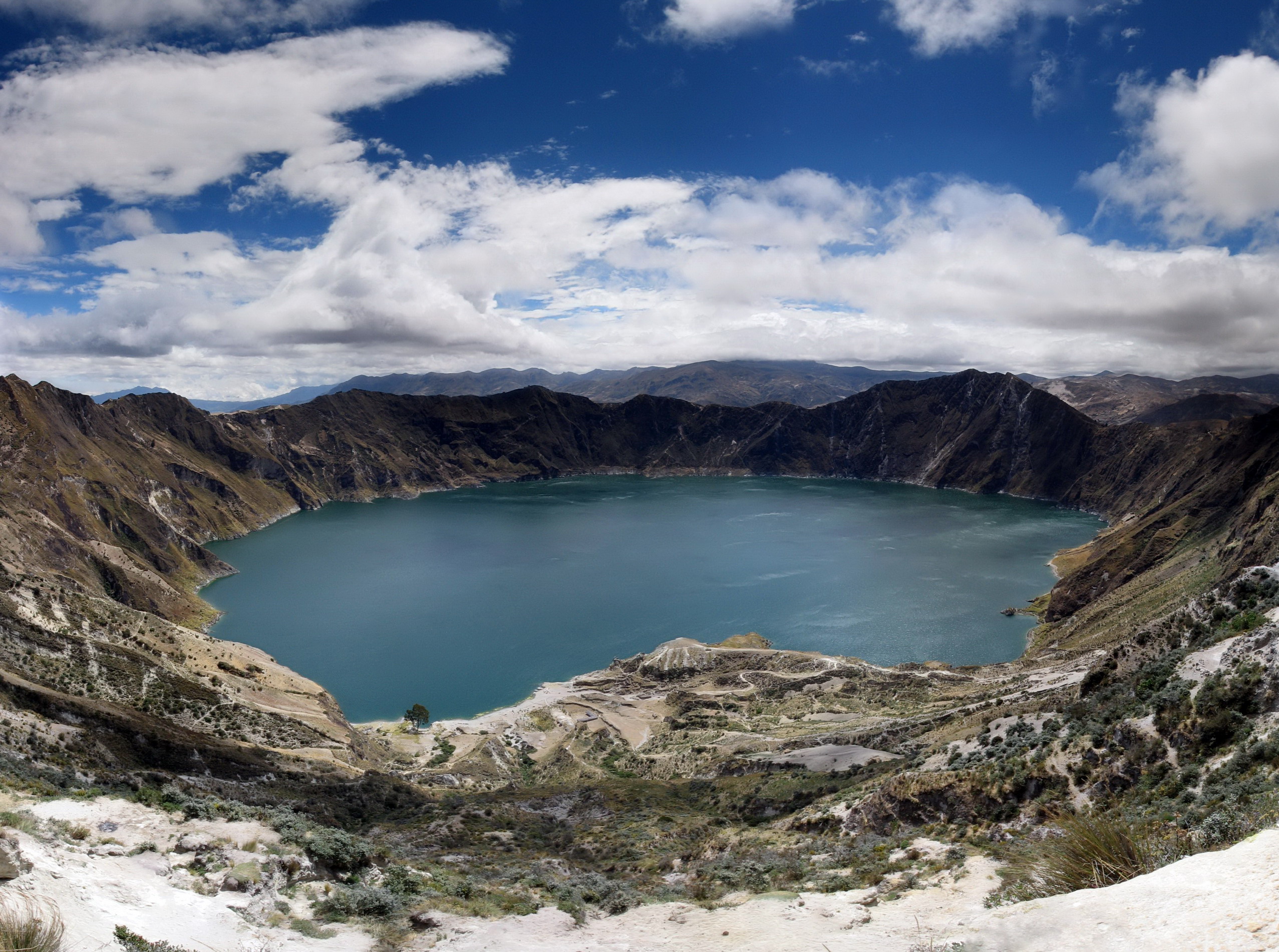 Lac de cratère du Quilotoa. | ||
| Géographie | ||
|---|---|---|
| Altitude | 3 914 m | |
| Massif | Cordillère Occidentale (Andes) | |
| Coordonnées | 0° 52′ 05″ sud, 78° 54′ 58″ ouest | |
| Administration | ||
| Pays | ||
| Province | Cotopaxi | |
| Géologie | ||
| Âge | 40 000 ans | |
| Type | Volcan de subduction | |
| Activité | Actif | |
| Dernière éruption | 4 février 1797 ? | |
| Code GVP | 352060 | |
| Observatoire | Instituto Geofísico | |
| Géolocalisation sur la carte : Équateur
| ||
| modifier |
||

Géographie
Comme le Cotacachi, le volcan Quilotoa possède un lac accessible par un chemin de randonnée (altitude 3 800 m).
Histoire
La première éruption historique de ce volcan s'est produite le . Une autre éruption se serait produite en 1859.
Voir aussi
Articles connexes
Liens externes
- Ressources relatives à la géographie :
 Portail de la montagne
  Portail du volcanisme
  Portail de l’Équateur
  Portail des lacs et cours d'eau
На других языках
[de] Quilotoa
Quilotoa ist der Name einer Caldera und des darin befindlichen Kratersees, zugleich der westlichste Vulkan in den ecuadorianischen Anden.[en] Quilotoa
Quilotoa (Spanish pronunciation: [kiloˈto.a]) is a water-filled crater lake and the most western volcano in the Ecuadorian Andes. The 3-kilometre (2 mi)-wide caldera was formed by the collapse of this dacite volcano following a catastrophic VEI-6 eruption about 800 years ago, which produced pyroclastic flows and lahars that reached the Pacific Ocean, and spread an airborne deposit of volcanic ash throughout the northern Andes.[1] This last eruption followed a dormancy period of 14,000 years and is known as the 1280 Plinian eruption.[2] The fourth (of seven) eruptive phase was phreatomagmatic, indicating that a Crater lake was already present at that time.[3] The caldera has since accumulated a 250-metre-deep (820 ft) crater lake, which has a greenish color as a result of dissolved minerals. Fumaroles are found on the lake floor and hot springs occur on the eastern flank of the volcano.[1][es] Quilotoa
El Quilotoa es un volcán lleno de agua en su cráter de 3 kilómetros (2 mi) de diámetro en su borde que se formó por el colapso de este volcán de dacita seguido por una erupción de VEI-6 hace aproximadamente 800 años, lo que produjo un flujo piroclástico y lahares (flujos de lodo) que alcanzaron el Océano Pacífico, que lanzó cenizas volcánicas a todo lo largo de los Andes septentrionales.- [fr] Quilotoa
[it] Quilotoa
Il Quilotoa è un lago di origine vulcanica dell'Ecuador, situato nella provincia del Cotopaxi, nella parte occidentale delle Ande ecuadoriane.[ru] Килотоа
Килотоа (исп. Quilotoa) — вулкан конической формы в Эквадоре высотой 3914 метров над уровнем моря. Расположен на границе хребта Восточная Кордильера, в 35 километрах к западо-северо-западу от города Латакунга. В центре вулкана расположена кальдера диаметром около 3 километров, заполненная озером. Килотоа является самым западным вулканом эквадорских Анд.Текст в блоке "Читать" взят с сайта "Википедия" и доступен по лицензии Creative Commons Attribution-ShareAlike; в отдельных случаях могут действовать дополнительные условия.
Другой контент может иметь иную лицензию. Перед использованием материалов сайта WikiSort.org внимательно изучите правила лицензирования конкретных элементов наполнения сайта.
Другой контент может иметь иную лицензию. Перед использованием материалов сайта WikiSort.org внимательно изучите правила лицензирования конкретных элементов наполнения сайта.
2019-2026
WikiSort.org - проект по пересортировке и дополнению контента Википедии
WikiSort.org - проект по пересортировке и дополнению контента Википедии