geo.wikisort.org - Reservoir
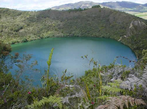
Lake Guatavita (Spanish: Laguna Guatavita) is located in the Cordillera Oriental of the Colombian Andes in the municipality of Sesquilé in the Almeidas Province, Cundinamarca department of Colombia, 57 km (35 mi) northeast of Bogotá, the capital of Colombia.
| Laguna Guatavita | |
|---|---|
 | |
 Laguna
Guatavita | |
| Location | Sesquilé, Cundinamarca, Colombia |
| Coordinates | 4°58′39.4″N 73°46′30.0″W |
| Max. length | 700 metres (2,300 ft) |
| Max. width | 700 metres (2,300 ft) |
| Surface area | 19.8 ha (49 acres) |
| Max. depth | 125 metres (410 ft) |
| Surface elevation | 3,000 m (9,800 ft) |
| References | [1][2][3] |

![Votive objects found at the bottom of Lake Guatavita in the British Museum.[4]](http://upload.wikimedia.org/wikipedia/commons/8/84/Lake_Guatavita-BM.JPG)
The lake is circular and has a surface area of 19.8 hectares. The earlier theories of the crater's origin being a meteorite impact, volcanic cinder, or limestone sinkhole are now discredited. The most likely explanation is that it resulted from the dissolution of underground salt deposits from an anticline,[3] resulting in a kind of sinkhole.
There are hot springs nearby in the municipality of Sesquilé, which means "hot water" in the now-extinct language of Chibcha, once spoken by the local indigenous people, the Muisca.
Spanish colonizers and Conquistadors knew about the existence of a sacred lake in the Eastern Ranges of the Andes possibly as early as 1531. The lake was associated with indigenous rituals involving gold. However, the first conquistador to arrive at the actual location was Gonzalo Jiménez de Quesada, possibly in June 1537, while on an expedition to the highlands of the Eastern Ranges of the Andes in search of gold. This brought the Spanish into first contact with the Muisca inhabiting the Altiplano Cundiboyacense, including around Lake Guatavita.
The lake is now a focus of ecotourism, and its association with the legend of El Dorado is also a major attraction.
Etymology
The name of the lake is derived from Chibcha, the language of the Muisca: gwa: mountain or gwata, gwate: high elevation, or gwatibita: high mountain peak; hence, a pool at a high mountain peak.[5] Another meaning is "End of the farmfields".[6]
Muisca mythology
Lake Guatavita was reputedly one of the sacred lakes of the Muisca, and a ritual conducted there is widely thought to be the basis for the legend of El Dorado, "the golden one". The legend says the lake is where the Muisca celebrated a ritual in which the zipa (named "El Dorado" by the conquistadors) was covered in gold dust, and then, venturing out into the water on a ceremonial raft made of rushes, dove into the waters, washing off the gold. Afterward, trinkets, jewelry, and other precious offerings were thrown into the waters by worshipers. A few artifacts of gold and silver found at bottom hold proof to this claim; however, to date, attempts to drain the lake or salvage the gold (see Lake Guatavita gold) have yielded no more than these.
Trivia
- Lake Guatavita is the filming location of the music video of the song No Te Pido Flores by Fanny Lú
See also
- Muisca religion
- Guatavita myth
- Lake Iguaque, another sacred lake of the Muisca
- Siecha Lakes, other lakes implicated in the El Dorado legend
- Tominé Reservoir, which buried the old town of Guatavita
- Tunjo, offer pieces in Lake Guatavita
- Gold Museum, Bogotá, where archaeological objects from the lake are displayed
References
- (in Spanish) Google Maps Area Calculator
- (in Spanish) Google Maps Elevation Finder
- Dietz ,R.S.; McHone, J.F. (1972). "Laguna Guatavita: Not Meteoritic, Probably Salt Collapse Crater". Meteoritics. 7 (3): 303. doi:10.1111/j.1945-5100.1972.tb00444.x.
- British Museum Collection
- M. Louis Ghisletti, Los Mwiskas, Bogota, 1954
- (in Spanish) Official website Guatavita Archived 2016-01-30 at the Wayback Machine
External links
 Media related to Laguna de Guatavita at Wikimedia Commons
- (in Spanish) Lake Guatavita - Colparques
Treasures of Colombia | |||||||||||||||||||||||||||||||||||||||||||||||||||||||||||||||
|---|---|---|---|---|---|---|---|---|---|---|---|---|---|---|---|---|---|---|---|---|---|---|---|---|---|---|---|---|---|---|---|---|---|---|---|---|---|---|---|---|---|---|---|---|---|---|---|---|---|---|---|---|---|---|---|---|---|---|---|---|---|---|---|
| |||||||||||||||||||||||||||||||||||||||||||||||||||||||||||||||
| |||||||||||||||||||||||||||||||||||||||||||||||||||||||||||||||
| |||||||||||||||||||||||||||||||||||||||||||||||||||||||||||||||
| |||||||||||||||||||||||||||||||||||||||||||||||||||||||||||||||
| |||||||||||||||||||||||||||||||||||||||||||||||||||||||||||||||
Source: . 2001. Nuestro patrimonio - 100 tesoros de Colombia - Our heritage - 100 treasures of Colombia, 1–311. El Tiempo.ISBN 958-8089-16-6 | |||||||||||||||||||||||||||||||||||||||||||||||||||||||||||||||
Muisca | |||||||||||||||||||||||||||
|---|---|---|---|---|---|---|---|---|---|---|---|---|---|---|---|---|---|---|---|---|---|---|---|---|---|---|---|
| |||||||||||||||||||||||||||
| |||||||||||||||||||||||||||
| |||||||||||||||||||||||||||
| |||||||||||||||||||||||||||
| |||||||||||||||||||||||||||
| |||||||||||||||||||||||||||
| |||||||||||||||||||||||||||

| Authority control |
|
|---|
На других языках
[de] Laguna de Guatavita
Die Laguna de Guatavita (Lagune von Guatavita) ist mit 19,8 ha Fläche ein kleiner Bergsee nordöstlich von Bogotá. Der See liegt in über 3000 m Höhe im Bergland von Cundinamarca auf dem Gebiet der Gemeinde Sesquilé. Sie wurde aufgrund des Eldorado-Mythos berühmt.- [en] Lake Guatavita
[fr] Laguna de Guatavita
La laguna de Guatavita est un lac situé en Colombie, dans le département de Cundinamarca, à une soixantaine de kilomètres au nord de la ville de Bogota.[ru] Гуатавита
Гуатави́та (исп. Laguna de Guatavita) — священное озеро муисков в Колумбии, расположенное в горах департамента Кундинамарка. Озеро имеет почти круглую форму и находится в кратере потухшего вулкана на высоте 3100 метров над уровнем моря.Другой контент может иметь иную лицензию. Перед использованием материалов сайта WikiSort.org внимательно изучите правила лицензирования конкретных элементов наполнения сайта.
WikiSort.org - проект по пересортировке и дополнению контента Википедии