geo.wikisort.org - Mountains
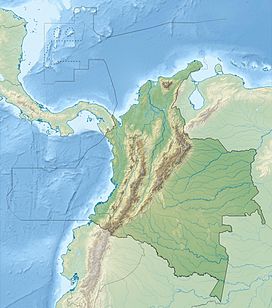
The Cerros de Mavicuri are three hills, located in eastern Colombia. More specifically, they are located 50 km (31 mi) south of the city of Inírida on the Inírida River. Geologically, the mountains are part of the Guiana Shield.
| Cerros de Mavecure | |
|---|---|
 Cerros de Mavecure | |
| Highest point | |
| Elevation | Pajarito: 712 m (2,336 ft) Mono: 480 m (1,575 ft) Mavicure: 170 m (558 ft) |
| Coordinates | 03°52′N 67°55′W |
| Geography | |
| Location | Guainía, Colombia |
| Geology | |
| Age of rock | Precambrian |
Ramsar Wetland | |
| Designated | 8 July 2014 |
Mavicuri is considered a sacred site by the multiple ethnic groups residing in the area. Its name means blowgun of the mountains, named after the tool used by the natives to catch prey.
The three mountains are called Pajarito (Little Bird), Mono (Monkey) and Mavicuri and are 712 m (2,336 ft), 480 m (1,570 ft), and 170 m (560 ft) respectively. They are made of volcanic rock and can only be accessed by river.
These mountains are considered one of the main tourist sites in the Department of Guainía and are located within a Puinave indigenous reserve.[1]
Popular culture
The Cerros de Mavicure are featured in the film Embrace of the Serpent. The Governor of the Guainía Department partly decorated Ciro Guerra, the director of the film, with the Order of the Inrida Flower for highlighting the land feature in the film.[2]
References
- "Sitios de Interés - Guainía".
- "Sitio web del Departamento de Guainía". guainia.gov.co. Retrieved 24 November 2015.[permanent dead link]
Другой контент может иметь иную лицензию. Перед использованием материалов сайта WikiSort.org внимательно изучите правила лицензирования конкретных элементов наполнения сайта.
WikiSort.org - проект по пересортировке и дополнению контента Википедии
