geo.wikisort.org - River
The Putumayo River or Içá River (Spanish: Río Putumayo, Portuguese: Rio Içá) is one of the tributaries of the Amazon River, southwest of and parallel to the Japurá River.[2][3]
| Putumayo River Río Içá | |
|---|---|
 Putumayo at Puerto Asis, Colombia | |
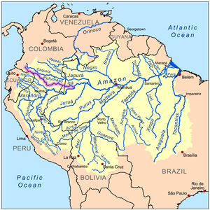 Map of the Amazon Basin with the Putumayo River highlighted in pink | |
| Location | |
| Countries |
|
| Physical characteristics | |
| Source | Andes Mountains |
| • location | East of Pasto, Colombia |
| • elevation | 3,000 m (9,800 ft) |
| Mouth | Amazon River |
• location | Santo Antônio do Içá, Brazil |
• coordinates | 3°8′6″S 67°58′27″W |
| Length | 1,813 km (1,127 mi) |
| Basin size | 120,545 km2 (46,543 sq mi)[1] |
| Discharge | |
| • location | mouth |
| • average | 8,520 m3/s (301,000 cu ft/s)[1] |
| Basin features | |
| Tributaries | |
| • left | Guamés River, San Miguel River |
| • right | Cara Paraná, Algodón River, Yaguas River |
Course
The Putumayo River forms part of Colombia's border with Ecuador, as well as most of the border with Peru. Known as the Putumayo in the former three nations, it is called the Içá when it crosses into Brazil. The Putumayo originates in the Andes Mountains east of the city of Pasto, Colombia. It empties into the Solimões (upper Amazon) near the municipality of Santo Antônio do Içá, Brazil. Major tributaries include the Guamués River, San Miguel, Güeppí, Cumpuya, Algodón, Igara-Paraná, Yaguas, Cotuhé, and Paraná de Jacurapá rivers.[2][4] The river flows through the Solimões-Japurá moist forests ecoregion.[5]
History
Exploration
In the late 19th century, the Içá was navigated by the French explorer Jules Crevaux (1847–1882). He ascended it in a steamer drawing 1.8 meters (6 ft) of water, and running day and night. He reached Cuembí, 1,300 km (800 mi) above its mouth, without finding a single rapid. Cuembí is only 320 km (200 mi) from the Pacific Ocean, in a straight line, passing through the town of Pasto in southern Colombia. Creveaux discovered the river sediments to be free of rock to the base of the Andes; the river banks were of argillaceous earth and the bottom of fine sand.
Rubber boom era
During the Amazon rubber boom of the late 19th and early 20th centuries, the land around the Putumayo became a major rubber-producing region, where Julio César Arana's Peruvian Amazon Company maintained a production network centered on the nearby city of Iquitos. This production network mainly relied on the labor of indigenous Indians, who suffered from widespread human rights abuses. These abuses were first publicized in 1909 within the British press by the American engineer Walter Hardenburg, who had been briefly imprisoned by Arana's private police force in 1907 while visiting the region; Hardenburg later published his book The Putumayo: The Devil's Paradise in 1913.[6]
In response to Hardenburg's exposé, the British government sent the consul Roger Casement (who had previously publicized Belgian atrocities in the rubber business of the Congo Free State) to investigate the matter; between 1910 and 1911, Casement subsequently wrote a series of condemnatory reports criticizing the atrocities of the PAC, for which he received a knighthood.[7]
Casement's reports later formed much of the basis for the 1987 book Shamanism, Colonialism, and the Wild Man by the anthropologist Michael Taussig, which analyzed how the acts of terror committed by British capitalists along the Putumayo River in Colombia had created a distinct "space of death."
Modern-day
Today the river is a major transport route. Almost the entire length of the river is navigated by boats.[4]
Cattle farming, along with the rubber trade, is also a major industry on the banks of the Içá. Rubber and balatá (a substance very much like gutta-percha, to the point where it is often called gutta-balatá) from the Içá area are shipped to Manaus, Brazil.
On March 1, 2008, Raúl Reyes and 14 of his fellow Revolutionary Armed Forces of Colombia guerrilla companions were killed while on the Ecuadorian side of the border by Colombian military forces.[8]
In November 2019, scientists from the Field Museum worked with partners from Colombia and Peru to perform a three-week "rapid inventory" of almost 7 million acres around the Putumayo, one of the few Amazonian rivers that remains undammed, documenting 1706 species.[9] The goal of these fast surveys of remote areas is to bring together local stakeholders to collaboratively protect wilderness.[10]
References
- "Archived copy" (PDF). meioambiente.am.gov.br. Archived from the original (PDF) on 2021-05-06. Retrieved 2021-10-03.
{{cite web}}: CS1 maint: archived copy as title (link) - Ziesler, R.; Ardizzone, G.D. (1979). "Amazon River System". The Inland waters of Latin America. Food and Agriculture Organization of the United Nations. ISBN 92-5-000780-9. Archived from the original on 8 November 2014.
- "Informações do Rio Içá" (in Portuguese). Brasilia, Brazil: Brazilian Ministry of Transport. 2014. Archived from the original on 2013-07-02. Retrieved 2015-01-10.
- "Putumayo River". Encyclopædia Britannica. Encyclopædia Britannica Inc. 2015. Retrieved 2015-01-10.
- Sears, Robin; Marín, César, Northern South America: northwestern Brazil, southern Colombia, and northern Peru (NT0163), WWF: World Wildlife Fund, retrieved 2017-03-26
- Mann, Charles (2012). 1493: Uncovering the New World Columbus Created. Vintage Books. pp. 330–333. ISBN 9780307278241.
- Fintan O'Toole, "The Multiple Hero", The New Republic, 2 August 2012, accessed 23 October 2014
- Abatido ‘Raúl Reyes’
- "Protecting One of the Amazon's Last Free-Flowing Rivers". Field Museum of Natural History. 22 April 2020. Retrieved 19 November 2021.
- Vriesendorp, Corine (9 March 2011). "Rapid Inventories". Field Museum of Natural History. Retrieved 19 November 2021.
External links
- . Collier's New Encyclopedia. 1921.
- Hardenburg, W.E. 1913. The Putumayo: The Devil's Paradise—Travels in the Peruvian Amazon Region and An Account of The Atrocities Committed Upon the Indians Therein. London: T. Fisher Unwin. https://archive.org/details/putumayodevilspa00hardrich
Treasures of Colombia | |||||||||||||||||||||||||||||||||||||||||||||||||||||||||||||||
|---|---|---|---|---|---|---|---|---|---|---|---|---|---|---|---|---|---|---|---|---|---|---|---|---|---|---|---|---|---|---|---|---|---|---|---|---|---|---|---|---|---|---|---|---|---|---|---|---|---|---|---|---|---|---|---|---|---|---|---|---|---|---|---|
| |||||||||||||||||||||||||||||||||||||||||||||||||||||||||||||||
| |||||||||||||||||||||||||||||||||||||||||||||||||||||||||||||||
| |||||||||||||||||||||||||||||||||||||||||||||||||||||||||||||||
| |||||||||||||||||||||||||||||||||||||||||||||||||||||||||||||||
| |||||||||||||||||||||||||||||||||||||||||||||||||||||||||||||||
Source: Wills, Fernando; et al. (2001). Nuestro patrimonio – 100 tesoros de Colombia [Our heritage – 100 treasures of Colombia] (in Spanish). El Tiempo. pp. 1–311. ISBN 958-8089-16-6. | |||||||||||||||||||||||||||||||||||||||||||||||||||||||||||||||
На других языках
[de] Río Putumayo
Der Río Putumayo, auf Quechua und historisch[2] Putumayu (putu „als Behälter dienende große Frucht“, mayu „Fluss“; auf Inga-Kichwa Valsayacu oder Walsayaku: walsa „Balsabaum“, yaku „Wasser“), im unteren Laufabschnitt (in Brasilien) Rio Içá, ist ein Fluss in Südamerika. Er durchfließt den Süden Kolumbiens und bildet streckenweise die Grenze zu Ecuador und zu Peru. Er mündet schließlich in Brasilien nahe San Antônio do Içá in den Amazonas.- [en] Putumayo River
[es] Río Putumayo
El río Putumayo, en Brasil, rio Içá (en quechua, putu mayu, de 'putu': vasija de fruto de árboles y 'mayu': río; que significaría «río que nace donde crecen las plantas cuyos frutos son usados como vasijas»), es un largo río amazónico que nace en el Nudo de los Pastos, en Colombia, y desemboca en el río Solimões (nombre del curso medio del río Amazonas), en Brasil, tras formar frontera en gran parte de su recorrido entre Colombia, Perú y Ecuador. Tiene una longitud de 1813 km y drena una cuenca de 148 000 km².[1] Tiene como principales afluentes los ríos Guamuez (140 km), San Miguel (240 km) e Igara Paraná (440 km). Es una importante vía de transporte fluvial, ya que es navegable casi en todo su recorrido.[it] Putumayo (fiume)
Il Putumayo (putu mayu in lingua quechua, Içá in portoghese) è un importante fiume nel bacino amazzonico occidentale che attraversa diversi paesi del Sud America: Colombia, Ecuador, Perù e Brasile. Il fiume è un affluente del Rio delle Amazzoni, nel quale confluisce nei pressi di Santo Antônio do Içá.[ru] Путумайо (река)
Путума́йо[1] (исп. Putumayo; на территории Бразилии — Иса́[2], порт. Içá) — река в Южной Америке[3], левый приток Амазонки.Другой контент может иметь иную лицензию. Перед использованием материалов сайта WikiSort.org внимательно изучите правила лицензирования конкретных элементов наполнения сайта.
WikiSort.org - проект по пересортировке и дополнению контента Википедии