geo.wikisort.org - Reservoir
Lake Tota (Spanish: Lago de Tota) is the largest lake in Colombia, located in the east of Boyacá department, inside the Sugamuxi Province, it is the source of the Upia River which flows into the Orinoco River basin.
| Lake Tota | |
|---|---|
 Satellite view of Lake Tota | |
 Lake Tota  Lake Tota | |
| Location | Boyacá |
| Coordinates | 5°32′24″N 72°55′12″W |
| Basin countries | Colombia |
| Max. length | 12 km (7.5 mi) |
| Max. width | 7.2 km (4.5 mi) |
| Surface area | 55 km2 (21 sq mi) |
| Max. depth | 62 m (203 ft) |
| Surface elevation | 3,015 m (9,892 ft) |
| Islands | San Pedro, Santo Domingo, La Custodia, Santa Helena, Cerro Chico |
| Settlements | Aquitania, Cuítiva, Iza, Tota |
The major town on the lake is Aquitania, located on its eastern side. Other nearby villages include Tota, Iza and Cuítiva.
Lake Tota was an important religious center for the Muisca culture. The name Tota comes from the Chibcha language of the Muisca and according to linguist Mariana Escribano its main name refers to "Astronomic Observatory", relating to its sacred uses for that culture. There are legends which relate to the way the lake was formed by the hands of ancient ancestors.
The area around Lake Tota is one of the major onion producing regions of Colombia. The western shore of the lake is a popular tourist destination for Colombians.
The average water temperature of 13 °C allowed for the introduction of rainbow trout (Onchorynchus mykiss) which created a valuable wild fishery (a mounted specimen in Restaurante Lucho, Aquitania, reportedly early in the 1990s, weighed 7 kg) and cage culture aquaculture, but predation on native fish species as led to the probable extinction of the pez graso or grease fish (Rhizosomichthys totae) believed native to only this lake.
Lake Tota is a breeding ground for several threatened or endangered bird species, including the least bittern (Ixobrychus exilis bogotensis), the Colombian ruddy duck (Oxyura jamaicensis andina), the Bogotá rail (Rallus semiplumbeus) and Apolinar's wren (Cistothorus apolinari). The last confirmed sighting of the Colombian grebe (Podiceps andinus), now considered to be extinct, was at Lake Tota.[1]
Etymology
In the Chibcha language of the Muisca people, Tota means "Farmfields of the river".[2]
Geography
Lake Tota consists of an area of 55.1 square kilometres (21.3 sq mi) with a length of 11.8 kilometers, a width of 6.2 kilometers and a depth of 58 meters being the largest natural lake in Colombia.
Gallery
 View of Lake Tota
 Lake Tota
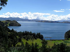 Lake Tota
 Lake Tota
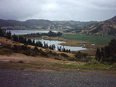 Lake Tota landscape
 Playa Blanca


See also
- Monster of Lake Tota
- Muisca religion
- Lake Guatavita, Lake Iguaque, Lake Suesca, Siecha Lakes
References
- Lake Tota - Bird Life International - accessed 02-05-2016
- (in Spanish) Etymology Tota - Excelsio.net
External links
| Wikimedia Commons has media related to Lake Tota. |
- (in Spanish) Lake Tota in the Province of Sugamuxi - videos and more information - accessed 02-05-2016
Treasures of Colombia | |||||||||||||||||||||||||||||||||||||||||||||||||||||||||||||||
|---|---|---|---|---|---|---|---|---|---|---|---|---|---|---|---|---|---|---|---|---|---|---|---|---|---|---|---|---|---|---|---|---|---|---|---|---|---|---|---|---|---|---|---|---|---|---|---|---|---|---|---|---|---|---|---|---|---|---|---|---|---|---|---|
| |||||||||||||||||||||||||||||||||||||||||||||||||||||||||||||||
| |||||||||||||||||||||||||||||||||||||||||||||||||||||||||||||||
| |||||||||||||||||||||||||||||||||||||||||||||||||||||||||||||||
| |||||||||||||||||||||||||||||||||||||||||||||||||||||||||||||||
| |||||||||||||||||||||||||||||||||||||||||||||||||||||||||||||||
Source: . 2001. Nuestro patrimonio - 100 tesoros de Colombia - Our heritage - 100 treasures of Colombia, 1–311. El Tiempo.ISBN 958-8089-16-6 | |||||||||||||||||||||||||||||||||||||||||||||||||||||||||||||||
Muisca | |||||||||||||||||||||||||||
|---|---|---|---|---|---|---|---|---|---|---|---|---|---|---|---|---|---|---|---|---|---|---|---|---|---|---|---|
| |||||||||||||||||||||||||||
| |||||||||||||||||||||||||||
| |||||||||||||||||||||||||||
| |||||||||||||||||||||||||||
| |||||||||||||||||||||||||||
| |||||||||||||||||||||||||||
| |||||||||||||||||||||||||||

Recreational dive sites in Colombia | ||
|---|---|---|
| Caribbean coast |
| |
| Caribbean insular |
| |
| Pacific |
| |
| Andean | ||
| ||
| Authority control |
|
|---|
На других языках
[de] Totasee
Der Totasee (spanisch: Laguna de Tota, Lago de Tota) ist ein in Kolumbien gelegener Hochandensee. Er befindet sich in 3015 Meter Höhe auf dem Gebiet des Departamento Boyacá. Die Länge beträgt zwölf Kilometer, der Umfang 47 Kilometer, die Fläche 56,2 km² und die durchschnittliche Tiefe 58 Meter. Damit ist er das größte Wasserreservoir Kolumbiens. In der nördlichen Hälfte des Sees befinden sich die drei Inseln San Pedro, Cerro Chiquito und Santa Helena, an der Ostseite die Halbinseln Potrero und Susacá. Der See liegt auf dem Gebiet der Gemeinden Aquitania, Cuítiva und Tota. Außerdem liegt die Gemeinde Iza in der Nähe. Die größte Stadt in der Umgebung ist Sogamoso, die sich 15 Kilometer nördlich des Sees befindet. Der See liegt drei Stunden von der kolumbianischen Hauptstadt Bogotá entfernt.- [en] Lake Tota
[es] Lago de Tota
El lago de Tota es un cuerpo de agua natural situado en el departamento de Boyacá, Colombia, en jurisdicción de los municipios de Cuítiva, Tota y Aquitania. Se encuentra ubicado a 34 km al sur de Sogamoso, aproximadamente 200 km al noroeste de Bogotá, la capital del país.[fr] Laguna de Tota
La laguna de Tota est un lac naturel situé dans le département de Boyacá, en Colombie. C'est la plus grande étendue d'eau du pays[1]. Elle est située à 15 km au sud de la ville de Sogamoso. Le lac est bordé par les municipalités de Iza, Cuitiva, Tota et Aquitania.[ru] Тота (озеро)
Тота[1] (исп. Lago de Tota) — озеро в департаменте Бояка (Колумбия), крупнейшее в стране и второе по высоте судоходное озеро во всей Южной Америке (после озера Титикака).Другой контент может иметь иную лицензию. Перед использованием материалов сайта WikiSort.org внимательно изучите правила лицензирования конкретных элементов наполнения сайта.
WikiSort.org - проект по пересортировке и дополнению контента Википедии