geo.wikisort.org - Reservoir
The Tominé Reservoir (Spanish: Embalse del Tominé) is a reservoir in northern Cundinamarca, Colombia about 60 kilometres (37 mi) north of Bogotá. It is 18 kilometres (11 mi) long and 4 kilometres (2.5 mi) wide, and when completely filled reaches a maximum depth of 38 metres (125 ft). Its objectives are to control water levels for hydroelectric plants in the region and supply drinking water to Bogotá. It is adjacent to the municipalities of Sesquilé and Guatavita.
| Tominé Reservoir | |
|---|---|
 Sunrays over Tominé Reservoir seen from Guatavita | |
 Tominé Reservoir | |
| Location | Guatavita & Sesquilé Cundinamarca |
| Coordinates | 4°57′51″N 73°49′51″W |
| Type | Artificial lake |
| Primary inflows | Bogotá River |
| Primary outflows | Bogotá River |
| Basin countries | |
| Max. length | 18 km (11 mi) |
| Max. width | 4 km (2.5 mi) |
| Surface area | 72 km2 (28 sq mi) |
| Max. depth | 38 m (125 ft) |
| Water volume | 690 hm3 (2.4×10¹⁰ cu ft) |
| Surface elevation | 2,581 m (8,468 ft)[1] |
| Islands | Various |
History
The reservoir was completed in 1967. The town of Guatavita was intentionally flooded for the construction and functioning of the reservoir. Guatavita was rebuilt on higher grounds. Today, Tominé hosts water sports and other water-related events. The reservoir, the biggest on the Bogotá savanna,[2] is seven times larger than the Neusa and Sisga Reservoirs.[3] At lowstand lake levels, the top of the tower of the old church of Guatavita is visible above the water level.
Gallery
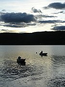 Fishing boats
September 2008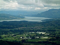 View of Tomine Reservoir
December 2008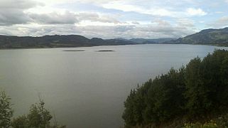 Tominé Reservoir
June 2013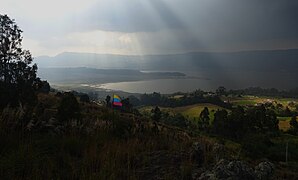 View of Tominé Reservoir
February 2017 Lowstand of Tominé Reservoir
February 2017


Panoramas


See also
References
- Google Maps Elevation Finder
- (in Spanish) Embalse de Tominé
- (in Spanish) CAR ordena medidas para descontaminar el embalse de Tominé
External links
- (in Spanish) Cundinamarca department official website
- (in Spanish) Guatavita - Universidad de los Andes
This Colombian location article is a stub. You can help Wikipedia by expanding it. |
На других языках
- [en] Tominé Reservoir
[es] Embalse de Tominé
El embalse de Tominé es un cuerpo de agua que se extiende por terrenos de la cabecera municipal de Guatavita y el municipio de Sesquilé, municipios ubicados al norte de la ciudad de Bogotá. Este embalse hace parte del sistema hídrico de la Sabana de Bogotá junto con los embalses del Sisga y Neusa. Tiene una longitud de 18 Kilómetros de largo por 4 ancho y 50 metros en promedio de profundidad, con capacidad para 690 000 000 de metros cúbicos de agua, por lo que se ha convertido en una reserva de vital importancia para el sector. Su capacidad es siete veces más grande que la del Sisga y que la del Neusa.[1]Другой контент может иметь иную лицензию. Перед использованием материалов сайта WikiSort.org внимательно изучите правила лицензирования конкретных элементов наполнения сайта.
WikiSort.org - проект по пересортировке и дополнению контента Википедии