geo.wikisort.org - Mountains
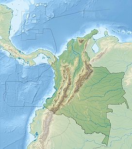
Petacas is a lava dome in the departments of Cauca and Nariño, Colombia.[1]
| Petacas | |
|---|---|
| Cerro de las Petacas | |
| Highest point | |
| Elevation | 4,054 m (13,301 ft) |
| Listing | Volcanoes of Colombia |
| Coordinates | 1°34′01″N 76°51′25″W |
| Geography | |
| Location | Cauca & Nariño |
| Parent range | Central Ranges, Andes |
| Geology | |
| Mountain type | Lava dome |
| Volcanic belt | North Volcanic Zone Andean Volcanic Belt |
| Last eruption | unknown |
Doña Juana volcano lies nearby.[1] Both volcanoes are located between the El Tablón Fault to the west and the San Jerónimo Fault to the east.[2]
See also
- List of volcanoes in Colombia
- List of volcanoes by elevation
References
- "Petacas". Global Volcanism Program. Smithsonian Institution.
- Plancha 411, 2002
Bibliography
- , and . 2002. Plancha 411 - La Cruz - 1:100,000, 1. INGEOMINAS. Accessed 2017-06-06.
На других языках
- [en] Petacas
[fr] Petacas
Le Petacas est un volcan de Colombie constitué d'un dôme de lave.Текст в блоке "Читать" взят с сайта "Википедия" и доступен по лицензии Creative Commons Attribution-ShareAlike; в отдельных случаях могут действовать дополнительные условия.
Другой контент может иметь иную лицензию. Перед использованием материалов сайта WikiSort.org внимательно изучите правила лицензирования конкретных элементов наполнения сайта.
Другой контент может иметь иную лицензию. Перед использованием материалов сайта WikiSort.org внимательно изучите правила лицензирования конкретных элементов наполнения сайта.
2019-2025
WikiSort.org - проект по пересортировке и дополнению контента Википедии
WikiSort.org - проект по пересортировке и дополнению контента Википедии

