geo.wikisort.org - Mountains
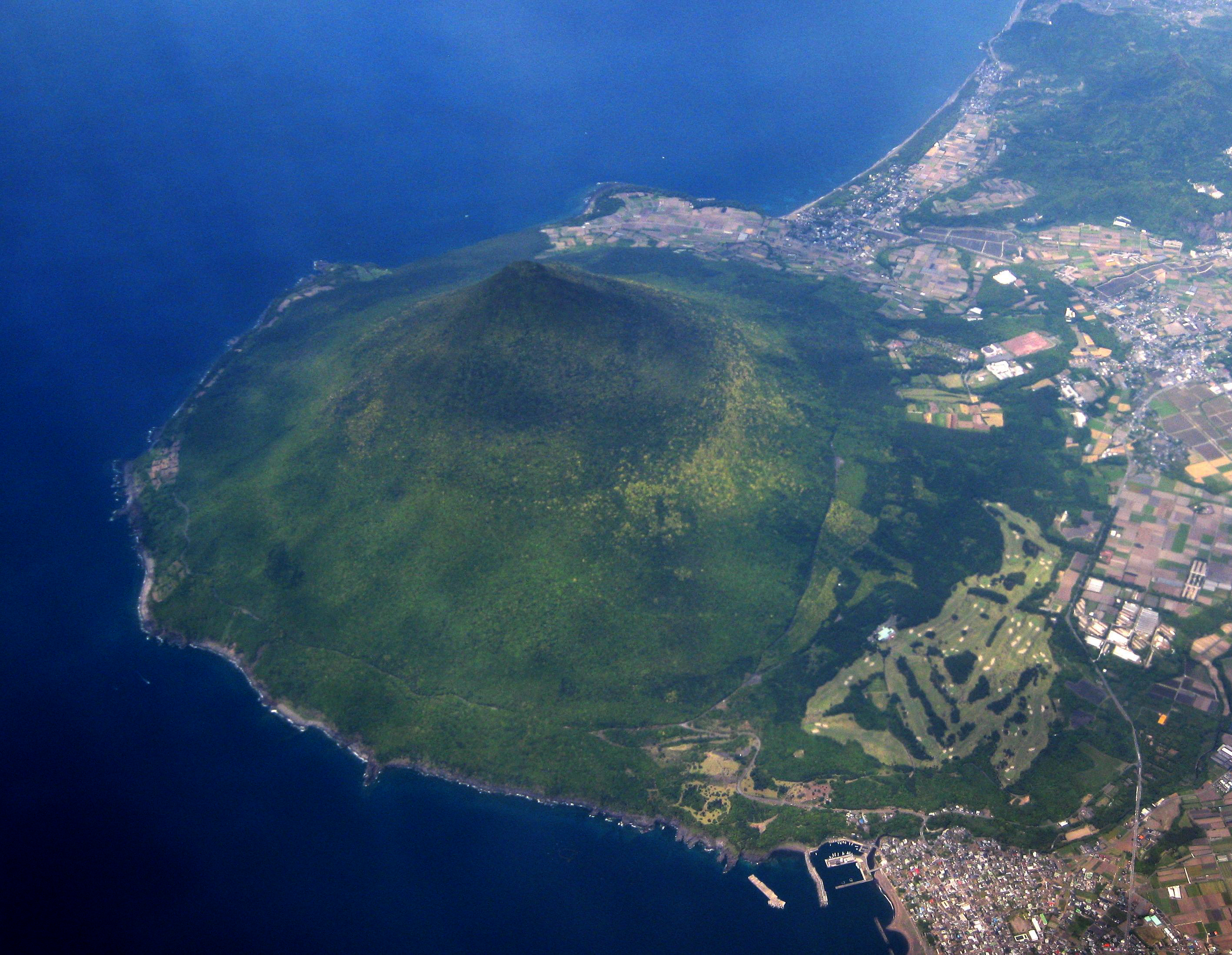
Kaimondake (開聞岳, Kaimondake, Kaimon-dake), or Mount Kaimon, is an undissected volcano – consisting of a basal stratovolcano and a small complex central lava dome[2] – which rises to a height of 924 metres above sea level near the city of Ibusuki in southern Kyūshū, Japan. The last eruption occurred in the year 885 CE. Because of its conic shape, Mt. Kaimon is sometimes referred to as "the Fuji of Satsuma".
| Kaimondake | |
|---|---|
| 開聞岳 | |
 | |
| Highest point | |
| Elevation | 924 m (3,031 ft) |
| Coordinates | 31°10′48″N 130°31′42″E |
| Geography | |
 Kaimondake Kyūshū, Japan | |
| Geology | |
| Mountain type | stratovolcano |
| Last eruption | 885 CE[1] |


Geography
Mt. Kaimon is located in the south of Kagoshima prefecture, Kyushu and is an important reference point for marine traffic because it is the southernmost prominence of the Satsuma Peninsula. This is one entrance marker to Kinko Bay (Kagoshima Bay) complimentary to the Ōsumi Peninsula. Together with Mt. Noma and Mt. Kinpo,[citation needed] it is used by marine traffic.
Geology
Part of the Ibusuki volcanic field, Mt. Kaimon defines the eastern margin of the old Ata Caldera. The total eruptive volume of tephra has been 3.1 km3 (0.74 cu mi) and 2.3 km3 (0.55 cu mi) of lava.[3]
There is a sea scarp which is 7.8km wide and 9.3km long, the shape is similar to a horseshoe in the seabed at the southern foot of the mountain. There is a lot of sediment at the foot of the mountain due to submarine landslides. It was found that there is a sea scarp underground on the south side of the mountain and it was caused by pressure from a submarine landslide before Mt. Kaimon was formed. [citation needed]
The sedimentary layer of ejecta from the eruption at the end of the 7th century is called ao-kora (ao means blue and kora is soil consisting of volcanic ash found in the southern part of the Satsuma Peninsula). The sedimentary layer of ejecta by the eruption at the end of the 7th century is called murasaki-kora (Murasaki means purple). These layers are a clue to know the changes in life in this era. It has become clear that a village was isolated by a large eruption with change in life style in the latter part of the 9th century. [citation needed]
Eruptive History


Mt. Kaimon began volcanic activity about 4000 years ago. From 3,000 years up to 885 years ago, large eruptions occurred 9 times and eruptions resulting in large amounts of lava occurred 10 times making twelve major eruptions to date.[3]
The two large eruptions in the historic written record are in 874 CE (Jogan era) and 885 CE (Nin-na era)[2] The complex layered central dome consists of a scoria cone topped by lava flows and ultimately a lava dome which was penetrated by a plug.[3] However the explosion crater at the top was last enlarged by the 885 CE eruption.[3]
| Date | DRE | Tephra | Lava | Comment |
|---|---|---|---|---|
| 885 CE | 0.129 km3 (0.031 cu mi) | 0.293 km3 (0.070 cu mi) | 0.007 km3 (0.0017 cu mi) | Km-Nn tephra pyroclastic flow to the east |
| 874 CE | 0.109 km3 (0.026 cu mi) | 0.237 km3 (0.057 cu mi) | - | Km-Jo tephra |
| 500 CE | 0.096 km3 (0.023 cu mi) | 0.260 km3 (0.062 cu mi) | 0.19 km3 (0.046 cu mi) | Km-11 |
| 200 CE | 0.02 km3 (0.0048 cu mi) | 0.041 km3 (0.0098 cu mi) | - | Km-10 |
| 0 CE | 0.368 km3 (0.088 cu mi) | 0.835 km3 (0.200 cu mi) | - | Km-9 |
| - 100 BCE | 0.102 km3 (0.024 cu mi) | 0.220 km3 (0.053 cu mi) | 0.01 km3 (0.0024 cu mi) | Km-8 |
| - 300 BCE | 0.097 km3 (0.023 cu mi) | 0.255 km3 (0.061 cu mi) | 0.015 km3 (0.0036 cu mi) | Km-7 |
| - 500 BCE | 0.039 km3 (0.0094 cu mi) | 0.097 km3 (0.023 cu mi) | - | Km-6 |
| - 900 BCE | 0.004 km3 (0.00096 cu mi) | 0.009 km3 (0.0022 cu mi) | 0.65 km3 (0.16 cu mi) | Km-5 under sea lava flows |
| - 1200 BCE | 0.128 km3 (0.031 cu mi) | 0.266 km3 (0.064 cu mi) | - | Km-4 large tephra fall to north west |
| - 1400 BCE | 0.002 km3 (0.00048 cu mi) | 0.004 km3 (0.00096 cu mi) | - | Km-3 |
| - 1600 BCE | 0.002 km3 (0.00048 cu mi) | 0.004 km3 (0.00096 cu mi) | - | Km-2 |
| - 2000 BCE | 0.274 km3 (0.066 cu mi) | 0.57 km3 (0.14 cu mi) | 1.339 km3 (0.321 cu mi) | Km-1 |
Transition of height
In 1895, the official height of Mt. Kaimon was 922.23 m (3,025.7 ft) from a second triangulation point which was at the summit of the mountain, but this was updated to 924 m (3,031 ft) by the Geospatial Information Authority of Japan in July 2001, because climbers pointed out that the height of the rocks on the top of the mountain were higher than the triangulation point.[4][citation needed]
Climbing
The spiral-shaped hiking trail climb of Mt. Kaimon takes about 3 hours. Mt. Kaimon is considerably lower than most of the mountains on the 100 famous Japanese Mountains list but as climbing starts from close to sea level there is an ascent of 900 metres (3,000 ft). Mt. Kaimon is a single peak but with summit rocky outcrops that allow views on all sides, such as Lake Ikeda to the north and the Pacific Ocean to the south.
Tourism
- Kaimon Sanroku Nature Park - The Tokara horse, is breed at the base of the mountain. [5]
- Kaimon Sanroku Fureai Park - There are log houses as well as camp sites. [6]
- Hirasaki Shrine
- Lake Ikeda - It is said that a mystery creature “Issie” lives there. The Canola flowering in January is very attractive. [7]
- Bohi Park - Memorial to those killed in the Pacific War in Philippines.
See also
References
- "Ata: Eruptive History". Global Volcanism Program. Smithsonian Institution. Retrieved 2021-06-24.
- Okuno, M.; Nakamura, T.; Kobayashi, T. (1997). "AMS 14C Dating of Historic Eruptions of the Kirishima, Sakurajima and Kaimondake Volcanoes, Southern Kyushu, Japan". Radiocarbon. 40 (2): 825–832. doi:10.1017/S0033822200018786.
- Fujino, N.; Kobayashi, T. (1997). "Eruptive history of Kaimondake Volcano, southern Kyushu, Japan". Kazan. 42 (3): 195–211. doi:10.18940/kazan.42.3_195. ISSN 0453-4360.
- 「開聞岳少しだけ高かった/新標高2メートル伸び924メートル=最高地点移動、登山者が指摘」南日本新聞2001年8月17日朝刊27面
- "Kaimon Sanroku Nature Park". Retrieved 2022-10-03.
- "Kaimon Sanroku Fureai Park". Retrieved 2022-10-03.
- "Lake Ikeda". Retrieved 2022-05-31.
External links
- Kaimondake - Japan Meteorological Agency (in Japanese)
- "Kaimondake: National catalogue of the active volcanoes in Japan" (PDF). - Japan Meteorological Agency
| Hokkaidō | |||||||||
|---|---|---|---|---|---|---|---|---|---|
| Tōhoku region Jōshinetsu region |
| ||||||||
| Kantō region | |||||||||
| Chūbu region |
| ||||||||
| Western Japan | |||||||||
| |||||||||
This Kagoshima Prefecture location article is a stub. You can help Wikipedia by expanding it. |
На других языках
[de] Kaimon-dake
Der Kaimon-dake (jap. 開聞岳) ist ein Schichtvulkan von 924 m Höhe in der Nansatsu-Vulkangruppe auf dem Verwaltungsgebiet von Ibusuki im südlichen Kyūshū (Japan). Der letzte Ausbruch erfolgte im Jahr 885.- [en] Mount Kaimon
[fr] Mont Kaimon
Le mont Kaimon (開聞岳?) ou Kaimondake est un volcan du Japon situé dans la préfecture de Kagoshima, dans la région du Kyūshū. Il fait partie des 100 montagnes célèbres du Japon.[ru] Каймон
Каймон, Каймон-даке или Каймон-Таке (яп. 開聞岳 Каймон-дакэ) — активный стратовулкан на японском острове Кюсю, в префектуре Кагосима[1]. Из-за своей конусообразной формы известен как «Сацумский Фудзи» (яп. 薩摩富士 Сацума-Фудзи)[1].Другой контент может иметь иную лицензию. Перед использованием материалов сайта WikiSort.org внимательно изучите правила лицензирования конкретных элементов наполнения сайта.
WikiSort.org - проект по пересортировке и дополнению контента Википедии