geo.wikisort.org - River
The Bug (Polish: Bug [buk] (![]() listen)) or Western Bug (Ukrainian: Західний Буг, Zakhidnyy Buh, Belarusian: Захо́дні Буг, Zakhodni Buh; Russian: Западный Буг, Zapadnyy Bug) is a major river mostly located in Eastern Europe that flows through Belarus, Poland, and Ukraine with a total length of 774 kilometres (481 mi).[1]
listen)) or Western Bug (Ukrainian: Західний Буг, Zakhidnyy Buh, Belarusian: Захо́дні Буг, Zakhodni Buh; Russian: Западный Буг, Zapadnyy Bug) is a major river mostly located in Eastern Europe that flows through Belarus, Poland, and Ukraine with a total length of 774 kilometres (481 mi).[1]
| Bug | |
|---|---|
 Bug River in the vicinity of Wyszków, Poland | |
 Bug River through Ukraine, Belarus and Poland | |
| Location | |
| Country | Poland, Belarus, Ukraine |
| Voivodeship Voblast Oblast | Podlaskie, Mazovian, Lublin, Brest, Lviv |
| Physical characteristics | |
| Source | |
| • location | near Verkhobuzh, Lviv Oblast, Ukraine |
| • coordinates | 49°52′0.5736″N 25°5′48.609″E |
| • elevation | 310 m (1,020 ft) |
| Mouth | Narew |
• location | near Serock, Poland |
• coordinates | 52°30′29.286″N 21°5′2.688″E |
• elevation | 75 m (246 ft) |
| Length | 774 km (481 mi) |
| Basin size | 38,712 km2 (14,947 sq mi) |
| Discharge | |
| • location | Serock |
| • average | 1 m3/s (35 cu ft/s) |
| Discharge | |
| • location | mouth |
| • average | 155 m3/s (5,500 cu ft/s) |
| Basin features | |
| Progression | Narew→ Vistula→ Baltic Sea |
A tributary of the Narew, the Bug forms part of the Belarus–Poland border and part of the Poland–Ukraine border border between Ukraine and Poland for 185 kilometres (115 mi),[2] and between Belarus and Poland for 178 kilometres (111 mi),[2][3] and is the fourth longest Polish rivers.
History
According to Zbigniew Gołąb, the Slavic hydronym Bug as *bugъ/*buga derives from Indo-European verbal root *bheug- (having cognates in old Germanic word *bheugh- etc. with meaning of "bend, turn, moves away"), with hypothetical original meaning of "pertaining to a (river) bend", and derivatives in Russian búga ("low banks of a river, overgrown with bushes"), Polish bugaj ("bushes or woods in a river valley or on a steep river bank"), Latvian bauga ("marshy place by a river").[4]
Traditionally, e.g. by the drafters of the Curzon Line, the Bug River has been considered to be the ethnographical border between the East and West as well as the border between Polish Orthodox and Catholic peoples.[5] [verification needed]
The Bug was part of the frontier between the slices of Poland occupied by Austria and Russia after the Third Partition of Poland in 1795, the southern half of the eastern border of the Duchy of Warsaw (1809-1815), Congress Poland (1815-1867), of the Vistula Land (1867-1913), and of the Regency Kingdom of Poland (1917-1918). The Bug also formed part of the dividing line between German Wehrmacht and Soviet Red Army zones specified in a secret clause of the German–Soviet Frontier Treaty of 28 September 1939 following the September 1939 invasion of Poland in the Second World War.
Geographic characteristics

The Bug is a left tributary of the Narew. It flows from the Lviv Oblast in the west of Ukraine northwards into the Volyn Oblast, before passing along the Ukraine-Polish and Polish-Belarusian border and into Poland, where it follows part of the border between the Masovian and Podlaskie Voivodeships. It joins the Narew at Serock, a few kilometers upstream of the artificial Zegrze Lake.[2]
This part of the Narew between the confluence and the Vistula is sometimes referred to as Bugo-Narew but on December 27, 1962, the Prime Minister of Poland's act abolished the name "Bugo-Narew", soon after Zegrze Lake was completed.[6]
On the Bug, a few kilometers from the Vysokaye in Kamenets District of the Brest Region, is the westernmost point of Belarus.[7] It is also connected with the Dnieper via the Mukhavets, a right-bank tributary, by the Dnieper-Bug Canal.
Basin
The total basin area of Bug is 38,712 square kilometres (14,947 sq mi) of which half, 19,239 square kilometres (7,428 sq mi) or, 50%, is in Poland.[1] Somewhat more than a quarter, 11,400 square kilometres (4,400 sq mi) or 29%, is in Belarus, and a bit under a quarter, 8,700 square kilometres (3,400 sq mi) or 22% lies in Ukraine.[2]
The climate of the Bug basin is temperate.[2]
The basin experiences annual high-water levels during spring flooding due to thawing snow, after which a low flow period starts and lasts until October or mid-November. Occasional summer floods often occur in the headlands, where mountains influence favorable flash-flood conditions. In Autumn the water level increases are inconsiderable; in some years they do not happen at all. During the winter the river can have temporary ice-outs that sometimes provoke ice jams, causing an increase of the level up to 2 metres (6.6 ft). The resultant water levels are changeable due to the instability of ice cover.[2]
Flooding
Significant floods during the last 60 years in Belarus were registered in 1958, 1962, 1967, 1971 and 1974.[2] The largest spring flood was observed in 1979, when the maximum water discharge was 19.1 cubic metres per second on 24 March 1979, at the village of Chersk; 166 cubic metres per second near the village of Tyukhinichi (Lyasnaya river) on 31 March 1979; and 269 cubic metres per second near Brest on 1 April 1979. A similar spring flood occurred in 1999, when the spring run-off in March–May exceeded the average annual value by almost half again (48%).
The last time the Bug flooded in Poland and Ukraine was in 2010 and the last time it flooded in Belarus was in 1999.[2]
Tributaries
Photo gallery
 Bug River in the vicinity of Włodawa
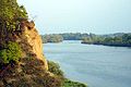 Bug River in the vicinity of Nur
 Bug River in the vicinity of Drohiczyn
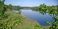 Bug River landscape near Nadbużański
 Bug River in the vicinity of Małkinia Górna
 Bug River in the vicinity of Serpelice


See also
- Bug Landscape Park
- Geography of Belarus – Overview of the geography of Belarus
- Geography of Poland – Geographical features of Poland
- Geography of Ukraine – Geography of the country of Ukraine
- Rivers of Belarus
- Rivers of Poland
- Rivers of Ukraine
- Southern Bug – River in Ukraine
References
- Statistical Yearbook of the Republic of Poland 2017, Statistics Poland, p. 85-86
- D.François; J. Kikken; P. Moiret; J. Paulzen; B. Stevens (2010). "Characteristics and cross-border cooperation within the river basins of the FLOOD-WISE project" (PDF). Zuyd University of Applied Sciences Maastricht, the Netherlands. pp. 49–55. Archived from the original (PDF) on 31 October 2013. Retrieved 29 October 2013.
- "Main Geographic Characteristics of the Republic of Belarus. Main characteristics of the largest rivers of Belarus". Land of Ancestors. Data of the Ministry of Natural Resources and Environmental Protection of the Republic of Belarus. 2011. Archived from the original on 15 January 2014. Retrieved 27 September 2013.
- Gołąb, Zbigniew (1992), The Origins of the Slavs: A Linguist's View, Columbus: Slavica, pp. 258–260, ISBN 9780893572310
- "POLSKIE PRZESIEDLENIA - HISTORIA NIEZNANA". www.lwow.com.pl. Retrieved 13 August 2018.
- (in Polish) "Monitor Polski" 1963, nr 3, poz. 6
- "Main Geographic Characteristics of the Republic of Belarus". Land of Ancestors. The Scientific and Production State Republican Unitary Enterprise “National Cadastre Agency” of the State Property Committee of the Republic of Belarus. 2011. Archived from the original on 21 September 2013. Retrieved 20 September 2013.
External links
- (in Polish) Bug in the Geographical Dictionary of the Kingdom of Poland (1880)
| Vistula | |
|---|---|
| Odra | |
| Vistula Lagoon | |
| Baltic Sea | |
| Black Sea | |
|---|---|
| Bug | |
| Danube | |
| Dnieper (Rapids) | |
| Dniester | |
| Don | |
| Prypiat | |
| San | |
| Sea of Azov | |
| Southern Bug | |
| Syvash |
|
Authority control | |
|---|---|
| General |
|
| National libraries | |
| Other |
|
На других языках
[de] Bug (Fluss)
Der Bug (ukrainisch und belarussisch Буг .mw-parser-output .Latn{font-family:"Akzidenz Grotesk","Arial","Avant Garde Gothic","Calibri","Futura","Geneva","Gill Sans","Helvetica","Lucida Grande","Lucida Sans Unicode","Lucida Grande","Stone Sans","Tahoma","Trebuchet","Univers","Verdana"}Buh; polnisch Bug), auch Westlicher Bug genannt (ukrainisch Західний Буг Sachidnyj Buh, belarussisch Заходні Буг Sachodni Buh, russisch Западный Буг Sapadny Bug) ist ein Fluss in der Ukraine, Polen und Belarus.- [en] Bug (river)
[es] Bug Occidental
El río Bug Occidental, también llamado Buh (en polaco, Bug; en bielorruso, Захо́дні Буг, en ruso, За́падный Буг; en ucraniano, Західний Буг), es un largo río de Europa oriental, de 772 km de longitud y que drena una cuenca hidrográfica de 39 420 km² (19 284 km² en Polonia).[it] Bug Occidentale
Il Bug Occidentale (in ucraino, bielorusso e polacco Bug) è un fiume, lungo 772 km, che scorre in Ucraina, Bielorussia e Polonia.[ru] Западный Буг
За́падный Буг (укр. За́хідний Буг, белор. Захо́дні Буг, польск. Bug) — река в Восточной Европе, на территории Украины, Белоруссии и Польши.Другой контент может иметь иную лицензию. Перед использованием материалов сайта WikiSort.org внимательно изучите правила лицензирования конкретных элементов наполнения сайта.
WikiSort.org - проект по пересортировке и дополнению контента Википедии