geo.wikisort.org - River
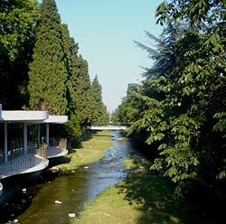
Uchan-su (Ukrainian: Учан-Су, Russian: Уча́н-Су or Водопадная Vodopadnaya, Crimean Tatar: Uçan Suv), is a river that flows in the South Coast of Crimea. The name translates from the Crimean Tatar language for 'swift water' .
| Uchan-su Vodopadnaya | |
|---|---|
 | |
| Location | |
| Country | Russia |
| Physical characteristics | |
| Source | |
| • location | Ai-Petri |
| Basin size | Black Sea |
The river runs into the Black Sea in the center city of Yalta. It begins at the foot of Ai-Petri, flows upstream the gorge and then at a distance of 2 km (1.2 mi) from the source forms the Uchan-su waterfall, located at an altitude of 390 meters (1,280 ft) and consists of several levels (the height of the waterfall is 98 meters (322 ft)).
The river water is used extensively for water supply and irrigation.
See also
- Waterfalls of Ukraine
На других языках
- [en] Uchan-su (river)
[es] Río Uchan-su
El río Uchan-su (en ruso, Уча́н-Су; en ucraniano, Учан-Су; en tártaro de Crimea, Uçan Suv) es un corto río costero que discurre por la vertiente meridional de la península de Crimea, y desemboca en el mar Negro en el centro de la ciudad de Yalta. El nombre se traduce del idioma tártaro de Crimea como «aguas veloces». La península de Crimea es administrada por Rusia desde 2014 y reclamada por Ucrania, este último cuenta con el reconocimiento internacional mayoritario.[ru] Водопадная (река, впадает в Чёрное море)
Водопа́дная[3][4][5] (Уча́н-Су́, укр. Учан-Су, крымскотат. Uçan Suv, Учан Сув) — река, протекающая по Южному берегу Крыма. Шарль Монтандон назвал реку Акар-Су[6].Текст в блоке "Читать" взят с сайта "Википедия" и доступен по лицензии Creative Commons Attribution-ShareAlike; в отдельных случаях могут действовать дополнительные условия.
Другой контент может иметь иную лицензию. Перед использованием материалов сайта WikiSort.org внимательно изучите правила лицензирования конкретных элементов наполнения сайта.
Другой контент может иметь иную лицензию. Перед использованием материалов сайта WikiSort.org внимательно изучите правила лицензирования конкретных элементов наполнения сайта.
2019-2025
WikiSort.org - проект по пересортировке и дополнению контента Википедии
WikiSort.org - проект по пересортировке и дополнению контента Википедии