geo.wikisort.org - River
The Desna (Russian: Десна́; Ukrainian: Десна) is a river in Russia and Ukraine, a major left-tributary of the Dnieper. Its name means "right hand" in the Old East Slavic language. It has a length of 1,130 km (702 mi), and its drainage basin covers 88,900 km2 (34,324 sq mi).[1]
| Desna Десна, Desna | |
|---|---|
 The Desna flows through Chernihiv, Ukraine. | |
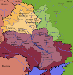 The Dnieper and the Desna rivers' drainage basin. In this map, Belarus is shown in yellow, Russia in green and Ukraine in deep red. | |
| Location | |
| Country | Russia, Ukraine |
| Cities | Bryansk, Novhorod-Siverskyi, Chernihiv |
| Physical characteristics | |
| Source | |
| • location | Smolensk Heights, Russia |
| Mouth | Desna Delta |
• location | just north of Kyiv, Ukraine |
• coordinates | 50°33′02″N 30°32′21″E |
| Length | 1,130 km (700 mi) |
| Basin size | 88,900 km2 (34,300 sq mi) |
| Discharge | |
| • location | Kyiv |
| • average | 360 m3/s (13,000 cu ft/s) |
| Basin features | |
| Progression | Dnieper→ Dnieper–Bug estuary→ Black Sea |
| Tributaries | |
| • left | Seym, Oster |
| • right | Sudost |
In Ukraine, the river's width ranges from 60 to 250 metres (200 to 820 ft), with its average depth being 3 m (10 ft). The mean annual discharge at its mouth is 360 m3/s (13,000 cu ft/s).[1] The river freezes over from early December to early April, and is navigable from Novhorod-Siverskyi to its mouth, a length of about 535 km (332 mi).[1]
The water level of the river reached its lowest recorded point in 140 years in June of 2020. This water level was 5 m (16 ft) below normal for that time of year.[2]
Geography
Course
The Desna originates in the Smolensk Heights of Smolensk Oblast, Russia. The river's source lies in Yelninsky District, east-southeast from the city of Smolensk and not far from Yelnya in a forest near the village of Naleti. The Desna then flows south through a low and swampy valley toward the city of Bryansk, where the river's right bank rises.
After its confluence with the Seym near the Russian-Ukrainian border, the river then widens, splitting into numerous smaller branches. Its right bank declines again near the city of Chernihiv, and again near one of its tributaries, the Oster, where the Desna continues its course through a low, muddy plain until it finally reaches its mouth near Kyiv at the Dnieper River.
Tributaries
The Desna has many tributaries. The most significant (length more than 100 km) are, from source to mouth:
Cities and towns on the Desna
- Yelnya, Russia
- Desnogorsk, Russia
- Zhukovka, Russia
- Seltso, Russia
- Bryansk, Russia
- Trubchevsk, Russia
- Novhorod-Siverskyi, Ukraine
- Chernihiv, Ukraine
- Oster, Ukraine
- Kyiv, Ukraine
The Svensky Monastery is located at the confluence of the Desna and the Sven River.
See also
- List of rivers of Russia
- List of rivers of Ukraine
References
- Десна, Great Soviet Encyclopedia.
- "Signs of Drought in European Groundwater". earthobservatory.nasa.gov. 2020-06-25. Retrieved 2021-04-14.
External links
- Desna River at the Encyclopedia of Ukraine
- Brockhaus and Efron Encyclopedic Dictionary — Desna, tributary of the Dnepr [dead link]
- Desna floodplains (Заплава Десни). Wetlands and swamps of Ukraine.
| Tributaries1 |  | |
|---|---|---|
| Reservoirs | ||
| Hydroelectric stations |
| |
| Canals |
| |
| Cities |
| |
| Crossings |
| |
| ||
| Black Sea | |
|---|---|
| Bug | |
| Danube | |
| Dnieper (Rapids) | |
| Dniester | |
| Don | |
| Prypiat | |
| San | |
| Sea of Azov | |
| Southern Bug | |
| Syvash |
|
Authority control | |
|---|---|
| General |
|
| National libraries | |
На других языках
[de] Desna (Dnepr)
Die Desna (russisch und ukrainisch Десна) ist ein 1.130 km langer linker Nebenfluss des Dnepr im westlichen bzw. europäischen Teil Russlands und in der Ukraine.- [en] Desna (river)
[es] Río Desná
El río Desná (en ruso: Десна; en ucraniano, Десна) es un largo río de Europa oriental que discurre por Rusia y Ucrania, el principal afluente del río Dniéper. El nombre del río significa «la mano derecha» en la antigua lengua eslava del este. Su longitud es de 1130 km y drena una cuenca de 88 900 km².[it] Desna
La Desna è un fiume dell'Europa orientale, affluente di sinistra del Dnepr. Scorre per circa 1.130 km (di cui 535 navigabili) nella zona nella Russia europea, in Bielorussia e in Ucraina.[ru] Десна (приток Днепра)
Десна́ (укр. Десна) — большая река, протекающая в Европейской части России и по территории Украины, левый приток Днепра, самый длинный из его притоков. Длина реки — 1130 км. Относительно судоходна от устья до Новгорода-Северского (535 км), уровень воды начиная с 2014 года в районе г. Чернигова в некоторой степени понизился[4], нерегулярное судоходство до Жуковки (выше Брянска). Площадь водосборного бассейна — 88,9 тыс. км².Другой контент может иметь иную лицензию. Перед использованием материалов сайта WikiSort.org внимательно изучите правила лицензирования конкретных элементов наполнения сайта.
WikiSort.org - проект по пересортировке и дополнению контента Википедии