geo.wikisort.org - River
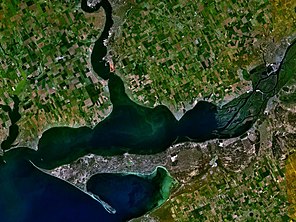
The Dnieper–Bug estuary (Ukrainian: Дніпровсько-Бузький лиман) is an open estuary, or liman, of two rivers: the Dnieper and the Southern Bug (also called the Boh River). It is located on the northern coast of the Black Sea and is separated from it by Kinburn Spit and the Cape of Ochakiv.
| Dnieper–Bug estuary | |
|---|---|
 Satellite view of the Dnieper–Bug estuary | |
 Dnieper–Bug estuary | |
| Location | Ukraine |
| Coordinates | 46°37′N 31°57′E |
| Type | estuary |
| Primary inflows | Dnieper, Southern Bug |
| Basin countries | Ukraine |
| Max. length | 63 km (39 mi) |
| Max. width | 17 km (11 mi) |
| Surface area | 1,006.3 km2 (388.5 sq mi) |
| Average depth | 4–6 m (13–20 ft) |
| Max. depth | 12 m (39 ft) |
| Settlements | Ochakiv, Mykolaiv |
Description

The estuary includes two parts: the wide Dnieper estuary (55 km long, up to 17 km wide), and the narrower Bug estuary (47 km long, from 5 to 11 km wide). The average depth is 6–7 metres (20–23 ft) and the maximum depth 12 metres (39 ft).
The estuary is important for transport, recreation, and fisheries. The most important port is Ochakiv.
Historical events
The estuary was a naval battleground in the Russo-Turkish War of 1787–1792. The Siege of Ochakov was a key event in that war, and naval battles – which involved the Russian Dnieper Flotilla,[1] John Paul Jones's deep-water fleet,[2][3] and the Ottoman Navy – included the First Battle of the Liman on June 7, 1788, and the Second Battle of the Liman on June 16 and 17.[1][3]
Key landmarks
The ruins of Pontic Olvia are located on the right bank of the Southern Bug (Boh River), right at its mouth.
There is an artificial island which is often mistaken for Berezan Island, but it is actually Pervomaisky Island.
References
- A. B. Shirokorad, The Russian-Turkish War, cited at "Успехи Лиманской флотилии" [Advance of the Flotilla to the Liman]. Military history of the 2nd half of the 18th century. Retrieved March 4, 2015. (in Russian)
- Morison, Samuel Eliot (1959). John Paul Jones - A Sailor's Biography. Atlantic Monthly Press. pp. 435–439. ISBN 978-1568524658. Retrieved March 4, 2015. (in English)
- Martelle, Scott (2014). The Admiral and the Ambassador: One Man's Obsessive Search for the Body of John Paul Jones. Chicago Review Press. pp. 102–106. ISBN 978-1613747308. Retrieved March 4, 2015. (in English)
External links
- Dnipro–Boh Estuary at the Encyclopedia of Ukraine (in Ukrainian)
На других языках
[de] Dnepr-Bug-Liman
Der Dnepr-Bug-Liman (ukrainisch Дніпровсько-Бузький лиман; russisch Днепро-Бугский лиман; krimtatarisch Usu-Limani[1]) ist die größte Flussmündung im Nordwesten des Schwarzen Meeres.- [en] Dnieper–Bug estuary
[fr] Golfe borysthénique
Le Golfe borysthénique (ukrainien : Дніпровсько-Бузький лиман : « liman du Dniepr et du Boug méridional ») est un liman situé sur les côtes nord-ouest de la mer Noire dont il est séparé par les péninsules du Kinbourn et d'Otchakiv. Ce large estuaire dont le nom français reprend la dénomination antique (Borysthenes étant le nom scythe du Dniepr)[1] est important pour le transport maritime, la pêche et le tourisme. Le port le plus important est Ochakiv mais la principale ville est Mykolaiv.[ru] Днепро-Бугский лиман
Дне́про-Бу́гский лима́н или Днепро́вско-Бугский лиман — открытый пресноводный лиман в северной части Чёрного моря, на территории Херсонской и Николаевской областей Украины. Порт — Очаков.Другой контент может иметь иную лицензию. Перед использованием материалов сайта WikiSort.org внимательно изучите правила лицензирования конкретных элементов наполнения сайта.
WikiSort.org - проект по пересортировке и дополнению контента Википедии