geo.wikisort.org - Island
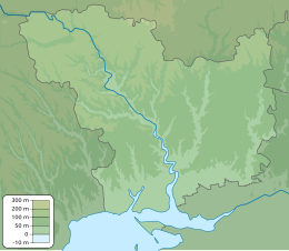
Berezan (Cyrillic: Береза́нь; Ancient Greek: Borysthenes; former Turkish: Pirezin) is an island in the Black Sea at the entrance of the Dnieper-Bug Estuary, Ochakiv Raion, Mykolaiv Oblast, Ukraine. Located 8 kilometers from the city of Ochakov and 4 kilometers from the resort village of Rybakovka. It is often being confused with the artificial island of Pervomaisky that is located within Dnieper-Bug Estuary. The Berezan island measures approximately 900 metres in length by 320 metres in width, the height of the northern part is 3-6 metres, the southern part is 21 metres. It is separated from the mainland (to which it may have been connected long ago) by about a mile and a half of shallow water. Berezan is an integral part of the historical and archaeological reserve of the National Academy of Sciences of Ukraine "Olvia". The island is uninhabited. In the summer, archaeological expeditions of the IA NASU and the State Hermitage Museum work here. The archaeological site is regularly destroyed as a result of unauthorized excavations.[1]
Native name: Березань | |
|---|---|
 Berezan Island as seen from a distance. | |
 Berezan | |
| Geography | |
| Location | Black Sea |
| Coordinates | 46°36′N 31°24.6′E |
| Total islands | 1 |
| Area | 0.24 km2 (0.093 sq mi) |
| Length | 0.9 km (0.56 mi) |
| Width | 0.4 km (0.25 mi) |
| Administration | |
Ukraine | |
| Region | Mykolaiv Oblast |
| District | Ochakiv Raion |
| Administered by | Olvia Preserve |
| Demographics | |
| Population | uninhabited (2001) |
| Additional information | |
 | |
History
Berezan was home to one of the earliest Greek colonies (possibly known as Borysthenes, after the Greek name of the Dnieper) in the northern Black Sea region. The island was first settled in the mid-7th century B.C.[2] and was largely abandoned by the end of the 5th century B.C., when Olbia became the dominant colony in the region.[3] In the 5th century BC, Herodotus visited it to gather information about the northern course of the eponymous river. The colony thrived on wheat trade with the Scythian hinterland.
In the Middle Ages, the island was of high military importance because it commanded the mouth of the Dnieper. During the period of Kievan Rus’ there was an important station on the trade route from the Varangians to the Greeks. It was there that Varangians first came into contact with the Greeks.

The only Runic inscription in Southern Ukraine, the Berezan' Runestone, was found on the island in 1905, now on exhibit in the Odessa Historical Museum. The inscription seems to have been part of a gravestone over the grave of a Varangian merchant from Gotland. The text reads: "Grani made this vault in memory of Karl, his partner."[4]
The control of the estuary (known in East Slavic sources as Beloberezhye, or White Shores) was disputed between Kievan Rus and Byzantium during the multiple Rus'–Byzantine Wars. At last the Rus'–Byzantine Treaty of 944 stipulated that the Rus' could use the island in the summertime, without establishing winter camps in the estuary or oppressing the citizens of Chersonesos fishing off shore. Nevertheless, at the conclusion of Svyatoslav I's war against Byzantium, this overking of Rus was allowed to evacuate his forces from Dorostolon to Beloberezhye, where his troops spent the hungry winter of 971/972.
During the XIV-XV centuries, when the entire Bug-Dniester interfluve was part of the Grand Duchy of Lithuania, there is only abrupt information about the island, and already at the turn of the XV-XVI centuries the island was ruled by the Crimean Khanate, but was not inhabited. At the same time, the Zaporozhian Cossacks knew about the island and used it for anchorage of ships and rest during numerous sea voyages.[5]
Zaporozhian Cossacks revived Berezan' as a fort during their campaigns against the Crimean Tatars and the Ottoman Empire in the 16th and 17th centuries. After the fall of neighbouring Ochakov to the Russians, the island was incorporated with the remainder of New Russia into the Russian Empire.
The site of the Greek colony and its necropolis have been periodically excavated since the 19th century; even though the site has suffered from erosion (and the tombs also from looting), the digs produced rich findings (archaic ceramics, inscriptions, etc.).
In March 1906, Pyotr Schmidt was executed on Berezan.
During World War II, the island became part of the Romanian Transnistria Governorate, along with all of the raion and city of Ochakiv.
In 2013, archaeologists found an encolpion cross on the island, dating from the late 11th - early 12th centuries, which gives rise to the existence of a settlement here, presumably designed to protect the Trade route from the Varangians to the Greeks.[6]
Gallery
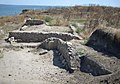 Archaeological excavations of Borysthenida on the island
 Abandoned lighthouses
 Obelisk to commemorate Lieutenant Schmidt
 Flying over Berezan Island in a Cessna 150L


Notes
- "Berezan Island". ochakov.glo (in Russian).
- Eusebius states in his Chronikoi kanones that the colony was founded in 647–646 BC, by settlers from Miletus.
- Treister, Michail J.; Vinogradov, Yuri G. "Archaeology on the Northern Coast of the Black Sea", American Journal of Archaeology, Vol. 97, No. 3. (1993), p. 538.
- Entry X UaFv1914;47 in Rundata 2.0
- Sapojnikov, Igor (2000). The assault on the island of Berezan by the Chornomorsky Cossacks (the island of Berezan and its capture in 1788). "Елтон-2" — "Гратек". pp. 11–12. ISBN 966-7588-11-4. Retrieved 4 July 2021.
- "An ancient Slavic cross was first found in the south of the country". kp.ua (in Russian).
Further reading
- Krÿzhitskii, Sergei D. "On the Types of Houses on the Island of Berezan", Ancient Civilizations from Scythia to Siberia, Vol. 11, Issue 3/4. (2005), pp. 181–197.
- Noonan, Thomas S. "The Grain Trade of the Northern Black Sea in Antiquity", American Journal of Philology, Vol. 94, No. 3. (1973), pp. 231–242.
- Solovyov, Sergei L. Ancient Berezan: The Architecture, History and Culture of the First Greek Colony in the Northern Black Sea (Colloquia Pontica; 4). Leiden: Brill Academic Publishers, 1999 (hardcover, ISBN 90-04-11569-2).
- Reviewed by Balbina Baebler in the Bryn Mawr Classical Review, 2000.06.01.
- Reviewed by Sara Owen in The Journal of Hellenic Studies, Vol. 121. (2001), pp. 216–217.
- Solovyov, Sergey L. "Berezan Island: The Main Features for Archaeology", Bilkent University. The Department of Archaeology & History of Art Newsletter, No. 3. (2004), pp. 17–19.
- Solovyov, Sergei L. "Monetary Circulation and the Political History of Archaic Borysthenes", Ancient Civilizations from Scythia to Siberia, Vol. 12, Issue 1/2. (2006), pp. 63–75.
See also
- Khortytsia Island
- Snake Island
Garðaríki | ||
|---|---|---|
Names in italics are settlements whose Norse names are not recorded | ||
| Volkhov-Volga trade route |
|  |
| Dvina-Dnieper trade route |
| |
| Other locations |
| |
| ||
Authority control | |
|---|---|
| General |
|
| National libraries | |
На других языках
[de] Beresan (Insel)
Beresan (ukrainisch und russisch Березань, altgriechisch Βορυσθένης .mw-parser-output .Latn{font-family:"Akzidenz Grotesk","Arial","Avant Garde Gothic","Calibri","Futura","Geneva","Gill Sans","Helvetica","Lucida Grande","Lucida Sans Unicode","Lucida Grande","Stone Sans","Tahoma","Trebuchet","Univers","Verdana"}Borysthenēs, Ἅγιος Αἰθέριος Hagios Aitherios, Heiliger Aitherios, altrussisch Белобережье Belobereschje) ist eine Insel im Schwarzen Meer in der Nähe des Dnepr-Bug-Limans.- [en] Berezan Island
[es] Isla Berezán
La isla Berezán (en ucraniano y ruso: Березань) es una isla del mar Negro localizada a la entrada del limán del Bug y Dniéper (en Ucrania).[fr] Île de Berezan
Berezan est une île de la mer Noire, à l'embouchure de l'estuaire du Dniepr et du Boug méridional, à 8 km d'Otchakiv, en Ukraine.[ru] Березань (остров)
Береза́нь[1] (укр. Березань), Остров Святого Елферия[2] или Айферия[3][4] — остров в Чёрном море, в 8 километрах от города Очаков и в 4 километрах от курортного посёлка Рыбаковка, на варяжском пути[2].Другой контент может иметь иную лицензию. Перед использованием материалов сайта WikiSort.org внимательно изучите правила лицензирования конкретных элементов наполнения сайта.
WikiSort.org - проект по пересортировке и дополнению контента Википедии