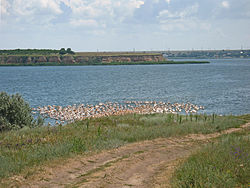
geo.wikisort.org - River
The Berezan is a Ukrainian river flowing into the Berezan Estuary of the Black Sea. The river is 49 km long, the catchment area is 890 km2. Slope 1.5 m / km. The trapezoidal river valley is 2 km wide. The channel is meandering, in the upper reaches 5 m wide, 1.2–1.5 m deep. In the summer it partially dries up. It is used for irrigation.
| Berezan | |
|---|---|
 River estuary | |
| Native name | Березань (Ukrainian) |
| Location | |
| Country | Ukraine |
| Physical characteristics | |
| Mouth | |
• coordinates | 46.8363°N 31.5868°E |
The river originates from the village of Stepove and flows through the territory of Voznesensk and Mykolaiv Raions of Mykolaiv Oblast.
In 1974, near the village of Yablonya, in the Berezan River basin, burial 11 of mound 11 was investigated, which belongs to the Sivashovka-type monuments of the 2nd half of the 7th century - early 8th century.[1]
Etymology
Vladimir Nikonov (1904 - 1988) indicates that the name may be derived from the Avestan berezant, Scythian bresant, which means high.[2]
History
In ancient times, the river was in Sarmatia and was named Sagaris. The Beresan District of Black Sea German colonists was located on the Berezan in the 19th century, when the area was known as South Russia. From 1809 to 1820, eleven German-Russian "mother colonies" were founded in the Beresan Valley: seven Catholic (Karlsruhe, Katharinental, Landau, München, Rastadt, Speyer, and Sulz) and four Lutheran (Johannestal, Rohrbach, Waterloo, and Worms).
See also
- Berezan Estuary
- Berezan Island
- Berezan' Runestone
Further reading
- Resources of surface waters of the USSR. Description of rivers and lakes and calculations of the main characteristics of their regime. - T. 6. Ukraine and Moldova. Issue 1. Western Ukraine and Moldova (excluding the Dniester basin). - L., Gidrometeoizdat, 1978. - 260-263 p.
References
- Komar A.V. Birchbark decoration of the scabbard of an early medieval sword from the Apple tree. Antiquities. Research. Problems. Collection of articles in honor of the 70th anniversary of N.P. Telnov, 2018. Pp. 409
- Yanko M.T. - K .: Znannya, 1998. - P. 39
External links
На других языках
[de] Beresan (Fluss)
Der Beresan (ukrainisch Березань) ist ein 49 km langer Zufluss zum Schwarzen Meer im Süden der Ukraine. Das Einzugsgebiet des Beresan beträgt 890 km² und sein Gefälle beträgt 1,5 m/ km. Der Küstenfluss hat eine Breite von 5 m und eine Tiefe von 1,2 bis 1,5 m.- [en] Berezan River
[ru] Березань (река)
Береза́нь (Береза́нка[источник не указан 1340 дней]) — река, впадающая в Березанский лиман Чёрного моря. Длина реки — 49 км, площадь водосборного бассейна — 890 км². Уклон 1,5 м/км. Долина реки трапециевидная, шириной 2 км. Русло извилистое, в верховьях шириной 5 м, глубиной 1,2—1,5 м. Летом частично пересыхает. Используется для орошения.Другой контент может иметь иную лицензию. Перед использованием материалов сайта WikiSort.org внимательно изучите правила лицензирования конкретных элементов наполнения сайта.
WikiSort.org - проект по пересортировке и дополнению контента Википедии