geo.wikisort.org - River
The North Crimean Canal (Ukrainian: Північно-Кримський канал, romanized: Pivnichno-Krymskyi kanal, Russian: Северо-Крымский канал, in the Soviet Union: North Crimean Canal of the Lenin's Komsomol of Ukraine) is a land improvement canal for irrigation and watering of Kherson Oblast in southern Ukraine and the Crimean Peninsula. The canal has multiple branches throughout Kherson Oblast and Crimea.
| North Crimean Canal | |
|---|---|
 Water intake structure at the start of the canal at Tavriysk, 800 m from the Kakhovka reservoir | |
 Map of the canal | |
| Specifications | |
| Length | 402.6 km (250.2 miles) |
| History | |
| Former names | North Crimean Canal of the Komsomol of Ukraine |
| Current owner |
|
| Original owner | Soviet government |
| Principal engineer | Ukrvodbud |
| Other engineer(s) | Ukrdiprovodbud |
| Date of act | September 21, 1950 |
| Construction began | 1961 |
| Date completed | December 29, 1975[citation needed] |
| Geography | |
| Start point | Tavriysk, Ukraine |
| End point | Kerch city water treatment facilities |
| Beginning coordinates | 46°45′55″N 33°23′40″E |
| Ending coordinates | 45°20′38″N 36°00′36″E |
| Branch(es) | Krasnoznamiansky Canal Soyedenitelny Canal |
| Connects to | Dnieper River |
Preparation for construction began in 1957, soon after the transfer of Crimea to the Ukrainian Soviet Socialist Republic in 1954. The main project works took place in three stages between 1961 and 1971. The construction was conducted by the Komsomol members sent by the Komsomol travel ticket (Komsomolskaya putyovka) as part of shock construction projects and accounted for some 10,000 volunteer workers.

Ukraine shut down the canal in 2014 soon after Russia annexed Crimea. Russia restored the flow of water in March 2022 during the 2022 Russian invasion of Ukraine.
A 2015 study found that the canal had been providing 85% of Crimea's water prior to the 2014 shutdown. Of the water from the canal, 72% went to agriculture and 10% to industry, while water for drinking and other public uses made up 18%.[1]
Overview
The canal begins at the city of Tavriysk, where it draws from the Kakhovka Reservoir fed by the Dnieper river, and runs for 402.6 km (250.2 mi) in a generally southeasterly direction, terminating at the small village of Zelnyi Yar (Lenine Raion). From there, a pipeline carries water to supply the city of Kerch at the eastern extreme of the Crimean Peninsula.[2] Seven water reservoirs lie along the main canal – they are Mizhhirne, Feodosiyske, Frontove, Leninske, Samarlynske, Starokrymske and Stantsiyne (Kerchenske).
Water flows by gravity from Tavriysk to Dzhankoy, where it is elevated by four pump stations to a height of over 100 m (330 ft) to energize its continued downstream flow. In Crimea, numerous smaller canals branch off the main channel, including the Razdolne rice canal, Azov rice canal, Krasnohvardiiske distribution canal, Uniting canal, and Saky canal. Through these, water is also supplied to the city of Simferopol.[2]

The idea to construct the canal was raised in the 19th century, particularly by the Russian-Finnish botanist Christian von Steven. It was not until after World War II when the decision was adopted in September 1950 by the Central Committee of the Communist Party of the Soviet Union and the Government of the Soviet Union. The decision was to build the Kakhovka Hydro Electric Station, South Ukrainian and North Crimean canals. In 1951 the Soviet postal service released a commemorative post stamp where the North Crimean Canal was categorized as one of the Great Construction Projects of Communism.
Construction of the canal and irrigation systems began in 1957 and was carried out in several stages. The first stage opened in October 1963, carrying water as far as Krasnoperekopsk in the north. In 1965 the canal was completed as far as the city of Dzhankoy in the center of Crimea. In 1971 the city of Kerch was reached. In December 1976 the canal was officially put into operation.[3][4]
2014–2022
After the Maidan revolution and the subsequent Russian annexation of Crimea in March 2014, Ukrainian authorities greatly reduced the volume of water flowing to the peninsula via the canal, citing a huge outstanding debt owed by Crimea for water supplied in 2013.[5] This included a semi-secret project organized by presidential aide Andriy Senchenkoto that dammed the canal south of Kalanchak, about 10 miles (16 km) north of the Crimean border, which began a severe water crisis in Crimea.[6] The reduction caused the peninsula's agricultural harvest, which is heavily dependent on irrigation, to fail in 2014.[5]
Crimean water sources were connected to the North Crimean Canal to replace the former Ukrainian sources. The objective was to restore irrigation and urban supplies to the Kerch Peninsula and to smaller communities on the east coast of Crimea.[7] In 2014, a reservoir was built to store water of the rivers of Eastern Crimea near the village of Novoivanovka, Nyzhnohirskyi Raion. The North Crimean Canal is connected with the Novoivanovka reservoir.[8]
According to official Russian statistics, the Crimean agricultural industry fully overcame the consequences of the blocking the North Crimean Canal and crop yields grew by a factor of 1.5 from 2013 by 2016.[9] The reported rapid growth in agricultural production in Crimea is due to the fact that, with the help of subsidies in the order of 2–3 billion rubles a year from the budget of the Russian Federation, agricultural producers in Crimea were able to increase their fleet of agricultural machinery.[10][11][12]
These official statistics contrast with reports of a massive shrinkage in the area under cultivation in Crimea, from 130,000 hectares in 2013 to just 14,000 in 2017,[13] and an empty canal and a nearly dry reservoir resulting in widespread water shortages,[14][15][6] with water only being available for three to five hours a day in 2021.[15] That same year, the New York Times cited senior American officials as stating that securing Crimea's water supply could be an objective of a possible incursion by Russia into Ukraine.[16][6]
On 24 February 2022, the first day of the 2022 Russian invasion of Ukraine, Russian troops advancing from Crimea established control over the North Crimean Canal.[17] The Head of the Republic of Crimea, Sergey Aksyonov, told local authorities to prepare the canal to receive water from the Dnieper river and resume the supply of water.[18][19] Two days later, Russian forces used explosives to destroy the dam that had been blocking the flow since 2014, and water supply resumed.[20][1]
Gallery
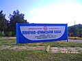 A sign with information about the canal
 A section of the canal in 2008, to the north of Simferopol
 The canal at Sovietskyi, Crimea, in 2010
 Pipeline - branch of the canal near Simferopol
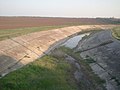 A dry branch of the canal in 2019


References
- "North Crimean Canal Fills With Water After Russian Forces Destroyed Dam". The Moscow Times. 4 March 2022. Archived from the original on 18 May 2022. Retrieved 18 May 2022.
- Tymchenko, Zinaida (13 May 2014). "Північно-Кримський канал. Історія будівництва" [North Crimean Canal. History of construction (reprint from the "Krymskie Izvestia" published in 2012]. Ukrayinska Pravda Історична правда (in Ukrainian). Archived from the original on 21 March 2022. Retrieved 2 March 2022.
- "Berezovsky, E. Северо-Крымский – дорога куда?" [North-Crimean is road to where?]. Ekologiya i Mir (Crimean Republican Association). Archived from the original on 2013-04-02. Retrieved 2013-06-24.
- "Bericht in Neues Deutschland vom 1. Januar 1976" [Report in Neues Deutschland of January 1, 1976]. Archived from the original on 28 September 2013. Retrieved 22 September 2013.
- "Russia fears Crimea water shortage as supply drops". BBC News. 25 April 2014. Archived from the original on 8 March 2021. Retrieved 26 April 2014.
- Troianovski, Anton (8 May 2021). "Where Ukrainians Are Preparing for All-Out War With Russia". The New York Times. Archived from the original on 24 May 2021. Retrieved 21 May 2021.
- "New Pipelines Start Supplying Fresh Water to Crimea". en.voicesevas.ru. Archived from the original on 2020-01-26. Retrieved 2015-05-25.
- "Крым покончил с водным шантажом Украины" [Crimea ended the water blackmail of Ukraine]. Svobodnaya Pressa (in Russian). 22 April 2015. Archived from the original on 21 March 2022. Retrieved 2 March 2022.
- "Продукция сельского хозяйства Республики Крым" [Agricultural products of the Republic of Crimea statistics с/х] (PDF) (in Russian). Archived from the original (PDF) on 7 November 2017. Retrieved 22 March 2019.
- "с/х машины Крыма" [Agricultural machines of Crimea] (PDF). Archived from the original (PDF) on 7 November 2017. Retrieved 22 March 2019.
- "Государственная поддержка сельского хозяйства - Правительство Республики Крым" [State support of agriculture - the Government of the Republic of Crimea]. msh.rk.gov.ru. Archived from the original on 7 November 2017. Retrieved 3 November 2017.
- "В Минсельхоз Крыма поступило 1200 заявок на получение субсидий на сумму более 1,5 миллиарда рублей — Министерство сельского хозяйства Республики Крым - Правительство Республики Крым" [The Ministry of Agriculture of the Crimea received 1,200 applications for subsidies worth more than 1.5 billion rubles - Ministry of Agriculture of the Republic of Crimea - Government of the Republic of Crimea]. msh.rk.gov.ru. Archived from the original on 7 November 2017. Retrieved 3 November 2017.
- Clara Ferreira Marques (19 March 2021). "Crimea's Water Crisis Is an Impossible Problem for Putin". www.bloomberg.com. Bloomberg. Archived from the original on 13 May 2021. Retrieved 24 March 2021.
- Mirovalev, Mansur (4 January 2017). "Dam leaves Crimea population in chronic water shortage". Al Jazeera. Archived from the original on 1 March 2022. Retrieved 21 May 2021.
- Mirovalev, Mansur (21 May 2021). "The devastating human, economic costs of Crimea's annexation". Al Jazeera. Archived from the original on 25 May 2021. Retrieved 21 May 2021.
- Cooper, Helene; Barnes, Julian E. (5 May 2021). "80,000 Russian Troops Remain at Ukraine Border as U.S. and NATO Hold Exercises". New York Times. Archived from the original on 14 January 2022. Retrieved 19 January 2022.
- "Российские войска берут под контроль Херсонщину: Крым готов получать воду" [Russian troops take control of Kherson region: Crimea is ready to receive water]. eadaily.com. 24 February 2022. Archived from the original on 24 February 2022. Retrieved 24 February 2022.
- "Российские войска вышли к Херсону и восстановили подачу воды в Крым" [Russian troops went to Kherson and restored water supply to the Crimea] (in Russian). RIA Novosti. 24 February 2022. Archived from the original on 24 February 2022. Retrieved 24 February 2022.
- "Canal in annexed Crimea to be readied for water from Ukraine's Dnieper, official says". National Post. Reuters. 24 February 2022. Archived from the original on 1 March 2022. Retrieved 24 February 2022.
- "В Крым пошла вода — украинской дамбы больше нет" [Water went to the Crimea - the Ukrainian dam is no more]. eadaily.com. 26 February 2022. Archived from the original on 21 March 2022. Retrieved 26 February 2022.
Authority control | |
|---|---|
| General |
|
| National libraries | |
| Other | |
На других языках
[de] Nord-Krim-Kanal
Der Nord-Krim-Kanal (ukrainisch Північно-Кримський канал .mw-parser-output .Latn{font-family:"Akzidenz Grotesk","Arial","Avant Garde Gothic","Calibri","Futura","Geneva","Gill Sans","Helvetica","Lucida Grande","Lucida Sans Unicode","Lucida Grande","Stone Sans","Tahoma","Trebuchet","Univers","Verdana"}Piwnitschno-Krymskyj kanal; russisch Северо-Крымский канал Sewero-Krymski kanal) ist ein 402,6 km langer Kanal im Süden der Ukraine und dient bis 2014 und dann in Folge ab 2022 zur Bewässerung der Krim.[1][2][3].- [en] North Crimean Canal
[es] Canal de Crimea del Norte
El canal de Crimea del Norte (ucraniano: Північно-Кримський канал, tr.: Pivnichno-Krimski kanal; ruso: Северо-Крымский канал, tr.: Sévero-Krymski kanal) es un canal que une el río Dniéper con Crimea (que ha sido anexada a Rusia desde marzo de 2014). Se usa para el riego de las tierras bajas del mar Negro y para proveer de agua a Crimea.[it] Canale della Crimea settentrionale
Il Canale della Crimea settentrionale (in ucraino: Північнокримський канал?, traslitterato: Pivničnokrims′kyj canal, in russo: Северо-Крымский канал?, traslitterato: Severo-Krymskij canal) è un'opera di ingegneria idraulica per l'alimentazione di acquedotti e canali d'irrigazione che parte nell'Oblast' di Cherson, nell'Ucraina meridionale e giunge fino alla penisola di Kerč' nella parte più orientale della Crimea.[1][ru] Северо-Крымский канал
Северо-Кры́мский кана́л (СКК, укр. Північно-Кри́мський кана́л (ПКК)) — оросительно-обводнительный канал, построенный в 1961—1971 годах для обеспечения водой маловодных и засушливых территорий Херсонской и Крымской областей Украинской ССР с забором воды из специально построенного в нижнем течении Днепра Каховского водохранилища, наполненного в 1955—1958 годах.Другой контент может иметь иную лицензию. Перед использованием материалов сайта WikiSort.org внимательно изучите правила лицензирования конкретных элементов наполнения сайта.
WikiSort.org - проект по пересортировке и дополнению контента Википедии