geo.wikisort.org - River
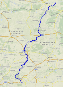
The Styr (Ukrainian: Стир; Belarusian: Стыр; Russian: Стырь) is a right tributary of the Pripyat, with a length of 494 km. Its basin area is 13,100 km2 located in historical region of Volhynia.[1][2][3]
| Styr | |
|---|---|
 Styr near Varash | |
 | |
| Native name |
|
| Location | |
| Country | Ukraine, Belarus |
| Physical characteristics | |
| Source | |
| • location | Lviv Oblast, Ukraine |
| Mouth | Pripyat |
• coordinates | 52.1076°N 26.5829°E |
| Length | 494 km (307 mi) |
| Basin size | 13,100 km2 (5,100 sq mi) |
| Basin features | |
| Progression | Pripyat→ Dnieper→ Dnieper–Bug estuary→ Black Sea |
The Styr begins near Brody, in the Ukrainian Oblast of Lviv, then flows into Rivne Oblast, Volyn Oblast, then into Brest Region of Belarus where it finally flows into the Pripyat.
During the Khmelnytskyi Uprising, in 1651 at Styr river took place important battle of Berestechko between armies of the Polish-Lithuanian Commonwealth and the Cossacks of Bohdan Khmelnytsky.[4]
During 1915–1916, the Styr river was the front line between the Austro-Hungarian and Imperial Russian armies.[5][6]
The river was also a barrier to the German invasion on June 22, 1941, during Operation Barbarossa on the South-Western Front.
Notable settlements located on the river are Lutsk, Staryi Chortoryisk and Varash.
Tributaries
- Left: Radostavka, Sudylivka, Chornohuzka, Lypa, Serna, Liutytsia, Okinka, Richytsia, Zhyduvka, Omelianyk
- Right: Ikva, Slonivka, Pliashivka, Boldurka, Liubka, Rudka, Kormyn, Riv, Konopelka, Sapalayivka
Images
 The Styr River on the map of Volyn Oblast
 Dnieper basin
 In frost near Boratyn


References
- Izsák Tibor (2007). Ukrajna természeti földrajza (pdf) (in Hungarian). II. Rákóczi Ferenc Kárpátaljai Magyar Főiskola. p. 95. Retrieved 2019-04-20.
- "NÉVJEGYZÉK-SZÓTÁR az UKRAJNA TERMÉSZETI FÖLDRAJZA tantárgyhoz" (pdf) (in Hungarian). II. Rákóczi Ferenc Kárpátaljai Magyar Főiskola. Retrieved 2019-04-20.
- "Стырь" (in Russian). Большая Советская Энциклопедия. Retrieved 2019-04-20.
- Hrushevsky, M. (2004). The Cossack Age, 1650–1653. History of Ukraine-Rus. Vol. Nine, Book One. Toronto: Canadian Institute of Ukrainian Studies. pp. 304–305. ISBN 1895571227.
- Marian Feldman (2009). From Warsaw, Through Łuck, Siberia, and Back to Warsaw. Lulu Inc. p. 32. ISBN 9780557093731.
- Churchill, Miller, and Reynolds (2016). "XXIII". The Story of the Great War, Volume 4: The World War. VM eBooks.
{{cite book}}: CS1 maint: multiple names: authors list (link)
| Black Sea | |
|---|---|
| Bug | |
| Danube | |
| Dnieper (Rapids) | |
| Dniester | |
| Don | |
| Prypiat | |
| San | |
| Sea of Azov | |
| Southern Bug | |
| Syvash |
|
Authority control | |
|---|---|
| General |
|
| National libraries | |
На других языках
[de] Styr
Der Styr (ukrainisch Стир, russisch Стырь) ist ein rechter Nebenfluss des Prypjat mit einer Länge von 494 km. Sein Einzugsgebiet beträgt 12.900 km²[1] (nach anderen Quellen 13.100 km²). Der Styr entspringt an den nordwestlichen Ausläufern der Podiler Anhöhe in der Nähe der ostgalizischen Stadt Brody. Anschließend fließt er durch die ukrainischen Oblaste Lwiw, Riwne und Wolyn und die belarussische Breszkaja Woblasz, wo er schließlich in den Prypjat mündet. Im Unterlauf durchfließt er die Pripjetsümpfe.- [en] Styr
[es] Río Styr
El río Styr (en ucraniano, Стир; en ruso, Стырь) es un río europeo que discurre por Ucrania y Bielorrusia.[it] Styr
Il fiume Styr (in ucraino: Стир?; in bielorusso: Стыр?) è un affluente di destra del fiume Pryp"jat', è lungo 494 km e la sua area di bacino è di 13.100 km².[ru] Стыр
Стыр[1][2][3][4] (укр. Стир, белор. Стыр), прежнее название Стырь[5][6][7][8] — река на северо-западной Украине и в Белоруссии, правый приток Припяти.Другой контент может иметь иную лицензию. Перед использованием материалов сайта WikiSort.org внимательно изучите правила лицензирования конкретных элементов наполнения сайта.
WikiSort.org - проект по пересортировке и дополнению контента Википедии