geo.wikisort.org - River
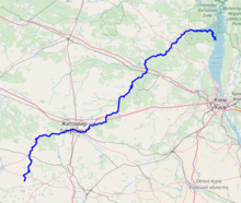
The Teteriv (Ukrainian: Тетерiв) is a right tributary of the Dnieper River in Ukraine. It has a length of 365 km and a drainage basin of 15,300 km².[2][3][1][4]
| Teteriv, Тетерiв | |
|---|---|
 Teteriv River near Zhytomyr | |
 | |
| Location | |
| Country | Ukraine |
| Physical characteristics | |
| Source | |
| • location | Zhytomyr Oblast |
| Mouth | Dnieper |
• location | Kyiv Reservoir |
• coordinates | 51°01′57″N 30°17′03″E |
| Length | 385 km (239 mi) |
| Basin size | 15,300 km2 (5,900 sq mi) |
| Discharge | |
| • average | 18,4 m³/s[1] |
| Basin features | |
| Progression | Dnieper→ Dnieper–Bug estuary→ Black Sea |
In the underflow the valley of the Teteriv in Polissia on up to 4 km, the width of the river widens up to 40-90 meter, before it flows into the Dnieper.[4]
The Teteriv is replenished predominantly by snow and rain. It usually freezes over from December to March.
Large cities located on the river are: Zhytomyr, the administrative center of the Zhytomyr Oblast, Korostyshiv, and Radomyshl.[4]
Tributaries
The important tributaries of the river are
- Left: Syvka, Ibr, Budychyna, Oleshka, Lisova, Perebehla, Hodynka, Shyika, Bobrivka, Kyzhynka, Chervonyi, Krutyi Yar, Perlivka, Pobytivka, Lisova Kamyanka, Kalynivka, Berezyna, Ruda, Levcha, Myka, Hlukhivka, Mezherichka, Myroch, Vyrva, Irsha, Ravka, Huche, Zamochek, Parnia, Kropyvnia, Zhereva, Liubsha, Bolotna, Terniava, Khocheva
- Right: Kobylykha, Teterivka, Chamyshel, Hremliaha, Tetynets, Hlybochok, Koshcha, Hnylopiat, Huiva, Rusiatynka, Dorohynka, Hnylyi Potik, Kokhanivka, Ivyanka, Krychanka, Velyki Lozy, Dubovets, Bilka, Kodra, Piskivka, Tal, Zdvyzh
References
- "Тетерев" (in Russian). Большая Советская Энциклопедия. Retrieved 2019-04-23.
- Izsák Tibor (2007). Ukrajna természeti földrajza (pdf) (in Hungarian). II. Rákóczi Ferenc Kárpátaljai Magyar Főiskola. p. 95. Retrieved 2019-04-23.
- "NÉVJEGYZÉK-SZÓTÁR az UKRAJNA TERMÉSZETI FÖLDRAJZA tantárgyhoz" (pdf) (in Hungarian). II. Rákóczi Ferenc Kárpátaljai Magyar Főiskola. Retrieved 2019-04-23.
- "Teteriv River". Encyclopedia of Ukraine. Retrieved 2019-04-23.
| Tributaries1 |  | |
|---|---|---|
| Reservoirs | ||
| Hydroelectric stations |
| |
| Canals |
| |
| Cities |
| |
| Crossings |
| |
| ||
| Black Sea | |
|---|---|
| Bug | |
| Danube | |
| Dnieper (Rapids) | |
| Dniester | |
| Don | |
| Prypiat | |
| San | |
| Sea of Azov | |
| Southern Bug | |
| Syvash |
|
Wikimedia Commons has media related to Teteriv (river).
На других языках
[de] Teteriw
Der Teteriw (ukrainisch Тетерів, russisch Тетерев .mw-parser-output .Latn{font-family:"Akzidenz Grotesk","Arial","Avant Garde Gothic","Calibri","Futura","Geneva","Gill Sans","Helvetica","Lucida Grande","Lucida Sans Unicode","Lucida Grande","Stone Sans","Tahoma","Trebuchet","Univers","Verdana"}Teterew) ist ein Fluss in der Ukraine. Er ist ein rechter Nebenfluss des Dneprs in der Dneprtiefebene und Polesien. Er hat eine Länge von 365 km und ein Einzugsgebiet von 15.100 km². Im Oberlauf fließt er bis zur Stadt Radomyschl durch das ukrainische kristalline Massiv in einem schmalen Tal mit hohen Ufern. Im Unterlauf weitet sich das Tal des Teteriw in Polesien auf bis zu 4 km, die Breite des Flusses beträgt 40 bis zu 90 m, bevor er in den zum Kiewer Stausee aufgestauten Dnepr mündet. Der Teteriw wird überwiegend durch Schnee und Regen gespeist. In der Regel ist er von Dezember bis März zugefroren.- [en] Teteriv
[es] Río Téteriv
El río Téteriv (en ucraniano, Те́терів; en ruso, Тетерев) es un río de Ucrania, un afluente por la izquierda del río Dniéper que desagua en el embalse de Kiev. Su longitud es de 365 km y su cuenca hidrográfica, unos 15 100 km². Es navegable en su curso final, donde también se ha construido una central hidroeléctrica.[it] Teteriv
Il Teteriv (ucraino:Тетерiв), è un fiume dell'Ucraina, affluente di destra del Dnepr. È lungo 365 km ed ha un bacino di drenaggio di 15.100 km². È alimentato soprattutto dalla neve, il suo flusso medio a 136 km dalla foce è di 18,4 m³/s. Nel suo basso corso forma la valle del Teteriv, nella regione della Polesia; qui la sua larghezza oscilla fra i 40 e i 90 m, prima di confluire nel Dnepr. Il Teteriv è solitamente ghiacciato da dicembre a marzo. Il fiume forma rapide e cascatelle nel suo tratto mediano mentre vicino alla foce il suo corso diventa tranquillo; è navigabile nel suo tratto finale ove ha anche sede una centrale idroelettrica.[ru] Тетерев (река)
Те́терев (укр. Те́терів) — река на Украине, правый приток Днепра, впадает в Киевское водохранилище. Протяжённость — 365 км, площадь бассейна 15 100 км²[1]. Средний расход воды — 18,4 м³/с.[источник не указан 1964 дня]Текст в блоке "Читать" взят с сайта "Википедия" и доступен по лицензии Creative Commons Attribution-ShareAlike; в отдельных случаях могут действовать дополнительные условия.
Другой контент может иметь иную лицензию. Перед использованием материалов сайта WikiSort.org внимательно изучите правила лицензирования конкретных элементов наполнения сайта.
Другой контент может иметь иную лицензию. Перед использованием материалов сайта WikiSort.org внимательно изучите правила лицензирования конкретных элементов наполнения сайта.
2019-2026
WikiSort.org - проект по пересортировке и дополнению контента Википедии
WikiSort.org - проект по пересортировке и дополнению контента Википедии