geo.wikisort.org - River
The Opir River (Ukrainian: О́пір) is located in Ukraine, within Stryi Raion of Lviv Oblast. It is a right tributary of the river Stryi (Dniester basin).
| Opir | |
|---|---|
 The Opir River near Hrebeniv, 2008 | |
| Native name | О́пір (Ukrainian) |
| Location | |
| Country | Ukraine |
| Oblast | Lviv Oblast |
| Physical characteristics | |
| Source | |
| • location | near Oporets[1] |
| • coordinates | 48°47′49.6″N 23°17′14.3″E |
| • elevation | 975 m (3,199 ft) |
| Mouth | Stryi |
• location | near Verkhnie Synovydne[2] |
• coordinates | 49°06′45.0″N 23°35′40.9″E |
• elevation | 370 m (1,210 ft) |
| Length | 58 km (36 mi)[3] |
| Basin size | 843 km2 (325 sq mi)[3] |
| Basin features | |
| Progression | Stryi→ Dniester→ Dniester Estuary→ Black Sea |
| Tributaries | |
| • left |
|
| • right |
|
Geography
The Opir River originates on the eastern slope of Velykyi Yavirnyk Mountain (Ukrainian: Великий Явірник) in the Verkhovinsky range, south of the village of Oporets.[1] It runs between the mountains of the Skole Beskids, mainly to the northeast and north. It flows into the Stryi River between the town of Verkhnie Synovydne and the village of Mezhybrody.
The Opir is 58 kilometres (36 mi) long, with a basin size of 843 km2 (325 sq mi).[3] Its average stream gradient is 10.4 m/km (55 ft/mi).[3] The river flows in a V-shaped valley, with a width varying between 150 m (490 ft) and 300 m (980 ft) in the lower reaches.[3] The floodplain is bilateral, sometimes unilateral, with a width ranging from 30 metres (98 ft) to 425 metres (1,394 ft). The shores are steep and occasionally swampy. The stream bed is rocky, with a width of 10 metres (33 ft) to 80 metres (260 ft), and a depth of 0.2 metres (7.9 in) to 1.2 metres (3 ft 11 in). The bottom is usually lined with pebbles of Carpathian sandstones. The river supplies water for settlements and for the irrigation of agricultural lands.
Recently, the river has become popular among tourists who go rafting.[4]
Tributaries
Eight small rivers and 31 streams with a total length of 94.3 kilometres (58.6 mi) and an area of 21.9 hectares (54 acres) flow into the river.
- Right: Kamianka, Chudyliv, Pavliv, Hrebenovets, Zelemyanka, Tsihla, Rozhanka, Slavka, Khokhlinsky, Pysarivka, Oporets.
- Left: Zakuty, Lavochanka, Dubrivka, Oriava, Yakhystiv, Holovchanka, Rovina.
Settlements
Several settlements are located on the river (in order from the source to the mouth): Oporets, Lavochne, Ternavka, Slavske, Tukhlia, Hrebeniv, Skole, Dubyna, Verkhnie Synovydne.
Gallery
![Opir river valley (view from the Zelemyanka ridge [uk]).](//upload.wikimedia.org/wikipedia/commons/thumb/7/7b/Opir-2.JPG/120px-Opir-2.JPG) Opir river valley (view from the Zelemyanka ridge).
Opir river valley (view from the Zelemyanka ridge).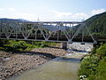 Railway bridge on the Opir.
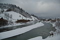 Opir in winter.
![Opir river valley (view from the Zelemyanka ridge [uk]).](http://upload.wikimedia.org/wikipedia/commons/7/7b/Opir-2.JPG)


References
- Prykhodko, M. M.; Romaniuk, V. V.; Kukhtar, D. V.; Bodnaruk, I. L.; Adamovych, M. V. (2020). "Use of geoinformation technology to study the structure and morphometric parameters of river basins". Geoinformatics: Theoretical and Applied Aspects 2020: 1–5. doi:10.3997/2214-4609.2020geo014.
- Saul Bernard Cohen, Saul Cohen (2008). "Verkhnye Syn'ovydne". The Columbia Gazetteer of the World: A to G. p. 4092. ISBN 9780231145541.
- Anna Hryhorivna Lutsyk, Pavlo Volodymyrovych Bosak (2019). "Антропогенне забруднення річок смт. Славське" [Anthropogenic pollution of rivers in the town of Slavske] (PDF). Проблеми та перспективи розвитку системи безпеки життєдіяльності (in Ukrainian): 163–165.
- N.Ye. Pankiv, O.R. Roik (2019). "Greenways as a model for the development of sustainable tourism in the Lviv region". Journal of Geology, Geography and Geoecology. 28 (1). doi:10.15421/111917. ISSN 2617-2909.
External links
| Black Sea | |
|---|---|
| Bug | |
| Danube | |
| Dnieper (Rapids) | |
| Dniester | |
| Don | |
| Prypiat | |
| San | |
| Sea of Azov | |
| Southern Bug | |
| Syvash |
|
На других языках
[de] Opir
Der Fluss Opir (ukrainisch Опір, russisch О́пир, polnisch Opór) ist ein rechter Nebenfluss des Stryj in der ukrainischen Oblast Lwiw.- [en] Opir (river)
[ru] Опир
О́пир (укр. Опір) — река на Украине, главный правый приток Стрыя, в который впадает между сёлами Верхнее Синевидное, Нижнее Синевидное[1] и Межиброды в Стрыйском районе Львовской области.Другой контент может иметь иную лицензию. Перед использованием материалов сайта WikiSort.org внимательно изучите правила лицензирования конкретных элементов наполнения сайта.
WikiSort.org - проект по пересортировке и дополнению контента Википедии