geo.wikisort.org - River
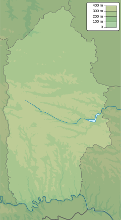
The Smotrych (Ukrainian: Смотрич, Polish: Smotrycz) is a left tributary of the Dniester, flowing through the Podillia upland of western Ukraine. Its length is 168 km (104 mi), and its drainage basin covers 1,800 km2 (694 mi2).[2] The average width of the river is 10–15 meters wide, and at one point exceeds 40 m.
| Smotrych Ukrainian: Смотрич | |
|---|---|
 The Smotrych River seen near the historic city of Kamianets-Podilskyi, Ukraine. | |
  | |
| Location | |
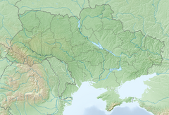
| Country | Ukraine |
| Oblast | Khmelnytskyi Oblast |
| City | Kamianets-Podilskyi |
| Physical characteristics | |
| Mouth | |
• coordinates | 48.5642°N 26.6378°E |
| Length | 168 km (104 mi) |
| Basin size | 1,800 km2 (690 sq mi) |
| Basin features | |
| Progression | Dniester→ Dniester Estuary→ Black Sea |
| Designation | |
Ramsar Wetland | |
| Official name | Lower Smotrych River |
| Designated | 29 July 2004 |
| Reference no. | 1401[1] |
The river is particularly notable for its tall banks, which give it a ravinelike appearance. It is used for water supply, irrigation, and fishing. A small hydroelectric station is situated on it, as well as the city of Kamianets-Podilskyi, the urban-type settlement Smotrych and the town of Horodok (Khmelnytskyi Oblast).
References
- "Lower Smotrych River". Ramsar Sites Information Service. Retrieved 25 April 2018.
- Смотрич (река), Great Soviet Encyclopedia
| Black Sea | |
|---|---|
| Bug | |
| Danube | |
| Dnieper (Rapids) | |
| Dniester | |
| Don | |
| Prypiat | |
| San | |
| Sea of Azov | |
| Southern Bug | |
| Syvash |
|
This article about a location in Khmelnytskyi Oblast is a stub. You can help Wikipedia by expanding it. |
На других языках
[de] Smotrytsch (Fluss)
Der Smotrytsch (ukrainisch und russisch Смотрич, polnisch Smotrycz) ist ein linker Nebenfluss des Dnister in der ukrainischen Oblast Chmelnyzkyj.- [en] Smotrych (river)
[it] Smotryč
Lo Smotryč (in ucraino: Смотрич?; in polacco Smotrycz) è un fiume ucraino, affluente di sinistra del Nistro. Ha una lunghezza di 168 km e un bacino idrografico di circa 1,800 km². Scorre nella parte occidentale della regione storica della Podolia e attraversa le cittadine di Horodok e Kam'janec'-Podil's'kyj.[ru] Смотрич (река)
Смо́трич (укр. Смотрич) — река в Хмельницкой области Украины, в исторической области Подолье, левый приток Днестра. Длина реки — 168 км, площадь водосборного бассейна — 1800 км²[1]. Преобладающая ширина русла — 10—15 м, наибольшая — 40 м.Текст в блоке "Читать" взят с сайта "Википедия" и доступен по лицензии Creative Commons Attribution-ShareAlike; в отдельных случаях могут действовать дополнительные условия.
Другой контент может иметь иную лицензию. Перед использованием материалов сайта WikiSort.org внимательно изучите правила лицензирования конкретных элементов наполнения сайта.
Другой контент может иметь иную лицензию. Перед использованием материалов сайта WikiSort.org внимательно изучите правила лицензирования конкретных элементов наполнения сайта.
2019-2026
WikiSort.org - проект по пересортировке и дополнению контента Википедии
WikiSort.org - проект по пересортировке и дополнению контента Википедии