geo.wikisort.org - River
The Narew ([ˈnarɛf]; Belarusian: Нараў, romanized: Naraŭ; Lithuanian: Narevas or Naruva; Sudovian: Naura; Old German: Nare; Ukrainian: Нарва, romanized: Narva) is a 499-kilometre (310 mi) river primarily in north-eastern Poland, which is also a tributary of the river Vistula. The Narew is one of Europe's few braided rivers, the term relating to the twisted channels resembling braided hair. Around 57 kilometres (35 mi) of the river flows through western Belarus.
| Narew Нараў, Narevas | |
|---|---|
 Braided channels of the Narew at Strękowa Góra. | |
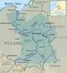
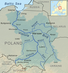 Narew as part of the Vistula watershed. | |
| Location | |
| Country | Poland, Belarus |
| Voivodeships / Voblasts | Hrodna, Podlaskie, Mazovian |
| Physical characteristics | |
| Source | |
| • location | north-eastern part of the Białowieża Forest near Dzikie Bagno, Belarus |
| • coordinates | 52°52′24.68″N 24°13′8.87″E |
| • elevation | 159 m (522 ft) |
| Mouth | |
• location | Modlin (Nowy Dwór Mazowiecki), Poland |
• coordinates | 52°26′N 20°41′E |
• elevation | 70.7 m (232 ft) |
| Length | 499 km (310 mi) |
| Basin size | 74,527 km2 (28,775 sq mi) |
| Discharge | |
| • location | mouth |
| • average | 313 m3/s (11,100 cu ft/s) |
| Discharge | |
| • location | entering Pułtusk |
| • average | 146 m3/s (5,200 cu ft/s) |
| Basin features | |
| Progression | Vistula→ Baltic Sea |
Etymology
The name of the river is from a Proto-Indo-European root *nr primarily associated with water (compare Neretva, Neris, Ner and Nur)[1] or from a Lithuanian language verb nerti associated primarily with diving and flood.[2]
Name of the lower portion
The portion of the river between the junctions with the Western Bug and the Vistula is also known as the Bugonarew, Narwio-Bug, Narwo-Bug, Bugo-Narew, Narwiobug or Narwobug. At the confluence near Zegrze the Bug is 1.6x longer, drains a 1.4x larger basin, and has a slightly greater average discharge (158 m³/s at Wyszków vs 146 m³/s at Pułtusk for the Narew, both ~25 km above the junction). Thus the Bugonarew was often considered part of the Bug river and the Narew a right tributary of the Bug.
On December 27, 1962, Prime Minister Józef Cyrankiewicz abolished the name Bugonarew soon after the Zegrze Reservoir had been constructed.[3] Since then the river Bug has been considered officially part of the river Narew's system, with the Bug being a left tributary of the Narew (by this classification, the River Narew is a right tributary of the River Vistula). The name Bugonarew however is still used, especially by the inhabitants of local towns, such as Pułtusk.
Geography
The Narew flows through the geographical region of Europe known as the Wysoczyzny Podlasko – Bialoruskie (English: Plateau of Podlasie and Belarus) located within the Podlaskie Voivodeship and Masovian Voivodeship of Poland and the Hrodna Voblast of Belarus.
| Country | Length[4] | Basin Area[4] |
|---|---|---|
| Belarus | 57 kilometres (35 mi) | |
| Poland | 443 kilometres (275 mi) | 53,846 square kilometres (20,790 sq mi) |
| Total | 499 kilometres (310 mi) | 74,527 square kilometres (28,775 sq mi) |
The Narew is the fifth longest Polish river.

Cities and towns


Tributaries
| Left Bank | Right Bank | Municipality | Characteristics | Country |
|---|---|---|---|---|
| Czoło | Bialowieza Forest | Belarus | ||
| Bierieżanka | Bialowieza Forest Siemianówka Marshland | Poland | ||
| Siemianówka | Siemianówka Marshland | |||
| Bondary | ||||
| Narewka | ||||
| Olszanka | ||||
| Ruda | Narew | |||
| Małynka | ||||
| Rudnia | ||||
| Czarna | Kaniuki | |||
| Łoknica | ||||
| Orlanka | Czerewki | |||
| Strabelka | Strabla | |||
| Liza | Suraż | Narew National Park | ||
| Awissa | Łapy | |||
| Turośnianka | ||||
| Niewodnica | Topilec | |||
| Waniewo | ||||
| Kurowo | ||||
| Horodnianka | Choroszcz | |||
| Supraśl | Złotoria | |||
| Jaskranka | Góra | |||
| Nareśl | Tykocin | |||
| Ślina | Targonie Wielkie | |||
| Zajki | ||||
| Góra Strękowa | ||||
| Biebrza | Biebrza National Park | |||
| Wizna | ||||
| Łojewek | Bronowo | Łomżyński Valley national Park | ||
| Gać | ||||
| Narwica | Łomża Piątnica | |||
| Łomżyczka | ||||
| Lepacka Struga | ||||
| Pisa | Nowogród | |||
| Ruż | Gontarze | |||
| Szkwa | Nowosiedliny | |||
| Rozoga | ||||
| Czeczotka | Ostrołęka | |||
| Omulew | Olszewo-Borki | |||
| Róż | Chełsty | |||
| Różan | ||||
| Orz | Brzóze Duże | |||
| Wymakracz | Ostrykół Dworski | |||
| Orzyc | Zambski Kościelne | |||
| Pełta | Pułtusk | |||
| Bug | Serock | Zegrze Reservoir | ||
| Rządza | ||||
| Nieporęt | ||||
| Topolina | ||||
| Wkra | Nowy Dwór Mazowiecki | mouth of the river at the Vistula |

History
On August 23, 1939, the Soviet Union and Germany signed the Molotov–Ribbentrop Pact, agreeing to divide Poland along the Narew, Vistula (Wisła), and San rivers.
On September 6, 1939, Polish military forces attempted to use the Narew as a defense line against German attack during the German invasion of Poland. This was abandoned the next day in favor of the Bug as German forces had already penetrated the defenses.
The Battle of Wizna was fought along the banks of the river between September 7 and September 10, 1939, between the forces of Poland and Germany during the initial stages of Invasion of Poland. Because it consisted of a small force holding a piece of fortified territory against a vastly larger invasion for three days at great cost before being annihilated with no known survivors, Wizna is sometimes referred to as a Polish Thermopylae in Polish culture.
On September 17, 1939, the USSR invaded Poland. By 28 September, the Soviet Army had reached the line of the rivers Narew, Bug River, Vistula and San – completing the division of Poland as negotiated in advance.
See also
- Narew National Park
- Narew Landscape Park
- Rivers of Poland
- Geography of Poland
References
- Witold Mańczak (1999). Wieża Babel (in Polish). Wrocław: Zakład Narodowy im. Ossolińskich. ISBN 83-04-04463-3.
- "Narew". mazowsze.szlaki.pttk.pl. Retrieved 13 August 2018.
- (in Polish) "Monitor Polski" 1963, nr 3, poz. 6
- Statistical Yearbook of the Republic of Poland 2017, Statistics Poland, p. 85-86
External links
Tributaries of the Vistula River | ||
|---|---|---|
| Forming rivers |
|  |
| Main tributaries of the left bank | ||
| Main tributaries of the right bank |
| |
| Distributary |
| |
| Vistula | |
|---|---|
| Odra | |
| Vistula Lagoon | |
| Baltic Sea | |
Authority control | |
|---|---|
| General |
|
| National libraries | |
На других языках
[de] Narew
Der Narew (belarussisch Нараў .mw-parser-output .Latn{font-family:"Akzidenz Grotesk","Arial","Avant Garde Gothic","Calibri","Futura","Geneva","Gill Sans","Helvetica","Lucida Grande","Lucida Sans Unicode","Lucida Grande","Stone Sans","Tahoma","Trebuchet","Univers","Verdana"}Narau, ukrainisch Нарва Narwa, deutsch historisch: Nare) ist ein Nebenfluss der Weichsel in Belarus und Polen von 484 km Länge, davon 448 km in Polen. 312 km des Narew sind schiffbar. Naturräumlich liegt sein Einzugsgebiet im Übergangssaum zwischen dem Osteuropäischen Tiefland und dem Mitteleuropäischen Tiefland.- [en] Narew
[es] Narew
El Narew (hidrónimo polaco, pronunciado /ˈnarɛf/; en lituano, Naura; en bielorruso, Нараў, Náraŭ) es un río del noreste de Polonia y oeste de Bielorrusia, afluente del Vístula; con una longitud de 484 kilómetros, de los cuales 448 km en Polonia y 36 km en Bielorrusia, es el quinto río más largo de Polonia. La cuenca del Narew comprende unos 75 175 km² de los que 53 873 se encuentran en Polonia.[it] Narew (fiume)
Il Narew (in antico prussiano e in lituano: Naura, in bielorusso: Нараў) è un fiume della Bielorussia occidentale e della Polonia nord-orientale, affluente del fiume Vistola. Con una lunghezza di 484 km (36 in Bielorussia e 448 in Polonia) è il quinto fiume più lungo della Polonia. L'area del bacino è di 75.175 km² (dei quali 53.873 in Polonia).[ru] Нарев
На́рев (белор. Нараў, польск. Narew) — река в западной Белоруссии и северо-восточной Польше, правый приток Вислы.Другой контент может иметь иную лицензию. Перед использованием материалов сайта WikiSort.org внимательно изучите правила лицензирования конкретных элементов наполнения сайта.
WikiSort.org - проект по пересортировке и дополнению контента Википедии