geo.wikisort.org - River
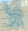
The Radomka is a river in central Poland and a left tributary of the Vistula. It has a length of 98 km and a basin area of over 2000 km2 (all in Poland). The river has its source in forests 4 km south from Przysucha, at the height of 310 meters above sea level. There is a retention reservoir, built in the valley of the Radomka in Domaniów, which has the largest surface area of any lakes in Mazowsze Voivodeship (5 – 7 km2). It is also utilised for recreation purposes.
| Radomka | |
|---|---|
 | |
| Location | |
| Country | Poland |
| Physical characteristics | |
| Mouth | |
• location | Vistula |
• coordinates | 51.7087°N 21.4353°E |
| Basin features | |
| Progression | Vistula→ Baltic Sea |
After flowing through the hills of the Lesser Poland Upland, the Radomka enters a wide urstromtal, to finally enter the Vistula near Ryczywol, at the height of 160 meters above sea level.
Puszcza Nature Reserve
The reserve, located in a forest at the source of the Radomka, was opened in 1978. Its purpose is to preserve natural wilderness, with its fir and beech trees.
Towns along the Radomka
Main tributaries
- Mleczna
- Narutówka
- Jastrzębianka
- Szabasówka
Sources
Tributaries of the Vistula River | ||
|---|---|---|
| Forming rivers |
|  |
| Main tributaries of the left bank | ||
| Main tributaries of the right bank |
| |
| Distributary |
| |
На других языках
[de] Radomka (Weichsel)
Die Radomka ist ein Fluss in Polen. Er ist ein linker Zufluss der Weichsel mit einer Länge von 98 km (nach anderen Angaben auch 106 km). Er durchfließt die Orte Przysucha, Skrzynno, Jedlińsk und Brzóza. Der Fluss ist Zufluss eines Stausees mit einer Fläche von 500 bis maximal 700 ha.- [en] Radomka
[ru] Радомка (река)
Радо́мка[1][2] (польск. Radomka) — река в Польше в Мазовецком воеводстве.Другой контент может иметь иную лицензию. Перед использованием материалов сайта WikiSort.org внимательно изучите правила лицензирования конкретных элементов наполнения сайта.
WikiSort.org - проект по пересортировке и дополнению контента Википедии