geo.wikisort.org - River
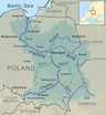
The Dunajec (Polish pronunciation: [duˈnajɛt͡s]); Goral dialects: Dónajec) is a river running through northeastern Slovakia and southern Poland. It is also regarded as the main river of the Goral Lands. It is a right tributary of the Vistula River. It begins in Nowy Targ at the junction of two short mountain rivers, Czarny Dunajec and Biały Dunajec (Black and White Dunajec). Dunajec forms the border between Poland and Slovakia for 17 kilometers[1] in the Pieniny Środkowe (Slovak: Centrálne Pieniny) range, east of the Czorsztyn reservoir.
| Dunajec | |
|---|---|
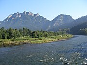
 Dunajec viewed from Trzy Korony | |
| Location | |
| Country | Poland, Slovakia |
| Physical characteristics | |
| Mouth | |
• location | Vistula |
• coordinates | 50.2431°N 20.7283°E |
| Length | 249 km (155 mi) |
| Basin size | 6,796 km2 (2,624 sq mi) |
| Discharge | |
| • average | 85.5 m3/s (3,020 cu ft/s) |
| Basin features | |
| Progression | Vistula→ Baltic Sea |
Geography
The Dunajec is 249 kilometers long, including its source river Czarny Dunajec,[1] which makes it Poland's thirteenth longest river. It has a basin area of 6,796 square kilometres (4,838 in Poland, and 1,958 in Slovakia).[1] On the Slovak/Polish border, it flows through the Zamagurie region, with attractions such as the Dunajec River Gorge, the Trzy Korony massif with a 500 metres (1,600 ft) precipice, Červený Kláštor, and two Pieniny castles in Czorsztyn and Niedzica.
Below the two source streams Dunajec flows through a broad valley called Nowotarska Basin. It then supplies the waters of the dam in Niedzica (Jezioro Czorsztyńskie Lake) and the dam in Sromowce Wyżne (Sromowce Wyżne reservoir). Flowing through the central part of the Pieniny range, it creates a picturesque turn at the Polish Slovak border between Sromowce Wyżne and Szczawnica, where it flows by Kotuńka rock which differentiates the area from the over parts of the river. Further down it turns to the north into the Western Beskid Mountains, and Sądecka Basin (where it merges with its own largest tributary, the Poprad river). It flows across an open valley of the Beskid Foothills and falls down across Rożnów Foothills (with two more dams: the Jezioro Rożnowskie Lake, and Jezioro Czchowskie Lake) and finally, it leads into the Sandomierz Basin and the valley of Vistula Lowlands. Dunajec flows into the Vistula River in the vicinity of Opatowiec.
Towns and townships

The Dunajec flows through or near these locations in Poland and north Slovakia:
|
|
Gallery
 Dunajec and the Trzy Korony Mountain
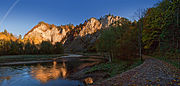 Dunajec in autumn
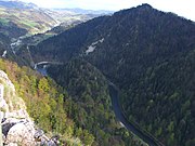 Dunajec Gorge in the Pieniny mountains
 Dunajec in Sromowce Niżne
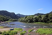 Dunajec in Szczawnica


See also
- Dunajec River Gorge
- Rivers of Poland
- Rivers of Slovakia
- 1934 flood in Poland
- Dunajec river castles
References
- Statistical Yearbook of the Republic of Poland 2017, Statistics Poland, p. 85-86
Tributaries of the Vistula River | ||
|---|---|---|
| Forming rivers |
|  |
| Main tributaries of the left bank | ||
| Main tributaries of the right bank |
| |
| Distributary |
| |
| Vistula | |
|---|---|
| Odra | |
| Vistula Lagoon | |
| Baltic Sea | |
Hydrography of Slovakia | ||||||||||||
|---|---|---|---|---|---|---|---|---|---|---|---|---|
| Rivers |
|  | ||||||||||
| Lakes |
| |||||||||||
| Reservoirs |
| |||||||||||
| River islands | ||||||||||||
Authority control | |
|---|---|
| General |
|
| National libraries | |
На других языках
[de] Dunajec
Der Dunajec (deutsch Dunajez/Dunajetz oder selten Dohnst) ist ein rechter nicht schiffbarer Nebenfluss der Weichsel in den Westkarpaten (Südpolen) von 247 Kilometern Länge, der mit seinen Quellflüssen Czarny Dunajec (Schwarzer Dunajec) und Biały Dunajec (Weißer Dunajec) in der Tatra entspringt. Die Länge des Dunajec wird von seinem Quellbach Wyżni Chochołowski Potok in der Westtatra gemessen.- [en] Dunajec
[es] Río Dunajec
El río Dunajec es un destacado río que discurre por el sur de Polonia, un afluente por la derecha del río Vístula. Nace en Nowy Targ en la conjunción de dos cortos ríos de montaña, Czarny Dunajec y Biały Dunajec (Dunajec Negro y Blanco). El Dunajec forma la frontera entre Polonia y Eslovaquia durante 27 km en las montañas Pieniny Środkowe (eslovaco: Centrálne Pieniny), al este del embalse de Czorsztyn. Es el único río que de Eslovaquia que drena en el mar Báltico.[it] Dunajec
Il Dunajec è un fiume lungo 274 km che attraversa (per 247 km) la parte meridionale della Polonia e che per 27 km forma il confine tra quest'ultima e la Slovacchia.[ru] Дунаец
Дунаец (словацк. Dunajec, польск. Dunajec) — река в Словакии и Польше. Длина — 274 км (243—251 км согласно БСЭ[1]), площадь бассейна реки — 6804 км² (4,8 тыс. км² в Польше и 1,9 тыс. км² в Словакии).Другой контент может иметь иную лицензию. Перед использованием материалов сайта WikiSort.org внимательно изучите правила лицензирования конкретных элементов наполнения сайта.
WikiSort.org - проект по пересортировке и дополнению контента Википедии