geo.wikisort.org - River
The Hron (Slovak: Hron; German: Gran; Hungarian: Garam; Latin: Granus) is a 271-kilometre (168 mi) long left tributary of the Danube[1] and the second-longest river in Slovakia. It flows from its source in the Low Tatra Mountains (below Kráľova hoľa) through central and southern Slovakia, emptying into the Danube near Štúrovo and Esztergom. Major cities and towns on the Hron are Brezno, Banská Bystrica, Sliač, Zvolen, Žiar nad Hronom, Žarnovica, Nová Baňa, Tlmače, Levice, Želiezovce, and Štúrovo.
| Hron | |
|---|---|
 The Hron near Starý Tekov | |
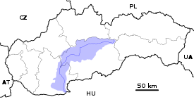  Current and watershed of the Hron River in Slovakia | |
| Location | |
| Country | Slovakia |
| Region | Banská Bystrica, Nitra |
| Physical characteristics | |
| Source | Hron |
| • location | Kráľova hoľa near Telgárt, Low Tatras, Banská Bystrica Region |
| • elevation | 980 m (3,220 ft) |
| Mouth | Danube |
• location | Kamenica nad Hronom, Nitra Region |
• elevation | 112 m (367 ft) |
| Length | 271 km (168 mi) |
| Basin size | 5,465 km2 (2,110 sq mi) |
| Discharge | |
| • average | 53.7 m3/s (1,900 cu ft/s) |
| • minimum | 7.6 m3/s (270 cu ft/s) |
| • maximum | 1,050 m3/s (37,000 cu ft/s) |
| Basin features | |
| Progression | Danube→ Black Sea |
| Tributaries | |
| • left | Slatina |
The river's basin covers 5,465 km2 (2,110 sq mi),[1] which is approximately 11 percent of Slovakia's territory.
Hron is a popular destination of water tourism.
Etymology
The name is probably of Germanic origin; *Granahua: gran – spruce, ahua – water.[2]
History
The name of the river was mentioned for the first time in 170, when Roman Emperor Marcus Aurelius wrote his Meditations at the Hron (Latin: Granus) river.[3] The first recorded medieval name was Gron (1075).[3] From the 17th century until the 1930s, the river was used for wood transport.
References
- Plán manažmentu povodňového rizikavčiastkovom povodí Hrona, p. 38
- Krško, Jaromír (2008). Hydronymia povodia Hrona (in Slovak). Banská Bystrica: Univerzita Mateja Bela. p. 81. ISBN 978-80-8083-611-5.
- Krško, Jaromír (June 2003). "Názvy potokov v Banskej Bystrici a okolí". Bystrický Permon. 1 (2): 8.
| Countries |
|  |
|---|---|---|
| Cities | ||
| Tributaries | ||
| Canals | ||
| See also |
| |
Hydrography of Slovakia | ||||||||||||
|---|---|---|---|---|---|---|---|---|---|---|---|---|
| Rivers |
|  | ||||||||||
| Lakes |
| |||||||||||
| Reservoirs |
| |||||||||||
| River islands | ||||||||||||
Authority control | |
|---|---|
| General |
|
| National libraries | |
На других языках
[de] Hron
Der Hron (deutsch die Gran; ungarisch Garam) ist ein 298 km langer, linker Nebenfluss der Donau. Er liegt vollständig auf dem Gebiet der Slowakei.- [en] Hron
[it] Hron
Hron (in ungherese: Garam, in tedesco: Gran) è un fiume tributario del Danubio da sinistra, lungo 298 km, ed è il secondo fiume per lunghezza della Slovacchia. Scorre dalla sorgente situata sui Bassi Tatra (sotto Kráľova hoľa) attraverso la Slovacchia centrale e meridionale, immettendosi nel Danubio presso Štúrovo e Esztergom.[ru] Грон (приток Дуная)
Грон (словацк. Hron) — вторая по длине река Словакии, левый приток Дуная. Длина реки — 276 км[1]. Площадь водосборного бассейна — 5465 км²[1].Другой контент может иметь иную лицензию. Перед использованием материалов сайта WikiSort.org внимательно изучите правила лицензирования конкретных элементов наполнения сайта.
WikiSort.org - проект по пересортировке и дополнению контента Википедии