geo.wikisort.org - Mountains
The Low Tatras or Low Tatra (Slovak: Nízke Tatry; Hungarian: Alacsony-Tátra) is a mountain range of the Inner Western Carpathians in central Slovakia.
This article needs additional citations for verification. (July 2008) |
This article may be expanded with text translated from the corresponding article in Slovak. (August 2012) Click [show] for important translation instructions.
|


It is located south of the Tatras proper, from which it is separated by the valleys of the Váh and Poprad rivers (the Liptov-Spiš abasement). The valley formed by the Hron River is situated south of the Low Tatras range. The ridge runs west-eastwards and is about 80 km long.
The Čertovica pass divides the range into two parts. The highest peaks of the Low Tatras are located in its western part. Ďumbier is the highest mountain at 2,042 m AMSL. Its neighbour Chopok (2,024 m) is accessible by a chairlift, and it is the most visited place in the Low Tatras. Other peaks in the western part include Dereše (2,004 m) and Chabenec (1,955 m). The highest peak in the eastern part is Kráľova hoľa (1,946 m). The best viewpoints in western part are Veľká Chochuľa, Salatín, Chabenec, Skalka, Chopok, Ďumbier, Siná, Poludnica and Baba.
Several karst areas are situated in limestone and dolomite strata at the southern and northern edges of the main ridge, which is composed of granite and gneiss. Among many discovered caves, Bystrianska Cave (Bystrianska jaskyňa), Cave of Dead Bats (Jaskyňa mŕtvych netopierov), Demänovská jaskyňa Slobody, Demänová Ice Cave (Demänovská ľadová jaskyňa), and Važecká Cave (Važecká jaskyňa) are open to the public. The biggest canyon is Hučiaky under Salatín in Ludrová valley near Ružomberok (7 caves - not open for public), suitable for canyoning. The highest waterfall is under Brankov near Ružomberok - Podsuchá (55 m high), reachable by green marked footpath from Podsuchá (20 min). The biggest tarn is Vrbické pleso in the Demänovská dolina Valley.
The mountains are densely forested and their rich fauna includes bear, wolf, and lynx. The alpine meadows are the habitat of chamois.
National Park
Most of the Low Tatras is protected by the Low Tatras National Park (Národný park Nízke Tatry; abbr. NAPANT), established in 1978. The area of the National Park is 728 km² (281.08 mi²) and the buffer zone takes 1,102 km² (425.48 mi²); 1,830 km² (706.56 mi²) together.
Tourism
Tourism is very popular in the Tatras. During the winter there are several ski resorts in Low Tatras, for example Jasná, Mýto pod Ďumbierom, and Tále. Not only are these hubs of hiking and cross-country skiing trails, but Jasna is the largest ski resort in Central Europe and is served by the tourist town of Liptovsky Mikulas. Liptovsky Mikulas also offers a range of summer activities such as rafting, kayaking, boating on the lake, fishing, a hot springs aqua park and hiking. There are many places to stay, restaurants and bars in the town. The steep northern slopes of the range are popular with climbers. Other attractions include an 18-hole golf course near Tále. The Path of the heroes of Slovak national uprising follows the axis of the mountain range. At the very top there are several huts or hotels that can offer refuge to those who want to traverse the entire range from east to west. Low Tatras are also a popular destination for Czech tourists.[1]
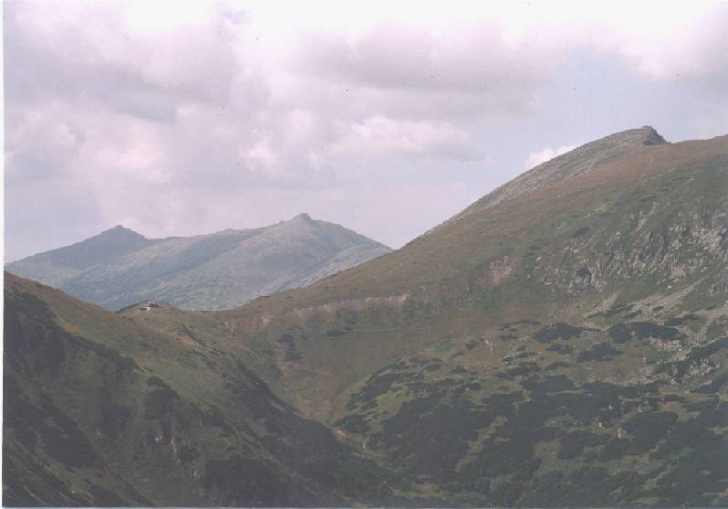
Panorama views


See also
- Mountain Rescue Service (Slovakia)
References
External links
| Wikimedia Commons has media related to Low Tatras. |
Authority control | |
|---|---|
| General |
|
| National libraries | |
На других языках
[de] Niedere Tatra
Die Niedere Tatra (slowakisch Nízke Tatry) ist ein Gebirgszug des geologischen Fatra-Tatra-Gebiets in den Karpaten in der Slowakei. Sie liegt südwestlich gegenüber der Hohen Tatra.- [en] Low Tatras
[es] Bajo Tatra
El Bajo Tatra o Tatras (eslovaco, Nízke Tatry; húngaro, Alacsony Tátra) es una cordillera en el centro de Eslovaquia. Se encuentra al sur del Alto Tatra, de la que está separada por el valle del río Váh. El valle formado por el río Hron se encuentra al sur de la cordillera del Bajo Tatra. La cresta va en dirección oeste-este y tiene unos 80 km de largo.[fr] Basses Tatras
Les Basses Tatras (en slovaque : Nízke Tatry ; en hongrois : Alacsony Tátra) sont un massif de montagnes des Carpates en Slovaquie. Il est situé au sud-ouest des Tatras et culmine à 2 043 m au Ďumbier.[it] Bassi Tatra
I Bassi Tatra (in slovacco: Nízke Tatry) sono un gruppo montuoso nella Slovacchia centrale. Si trovano a sud degli Alti Tatra, da cui sono separati dalla valle del fiume Váh. La valle formata dal fiume Hron si trova a sud della catena montuosa. La catena si estende per circa 80 km da ovest a est.[ru] Низкие Татры
Низкие Татры[1] (словацк. Nízke Tatry) — горный массив в центральной Словакии, часть Фатранско-Татранской области. Наивысшая точка — гора Дюмбьер, 2043 м. Территория Низких Татр является народным парком, благодаря своей уникальной природе. Во многих местах, например, между Чертовицей и Кралёвой Голей здесь ещё сохранились девственные леса. Низкие Татры являются вторым по значению после Высоких Татр туристическим местом Словакии — то же самое имя носит национальный парк. Наиболее современные и посещаемые туристические центры расположены у гор Хопок и Дюмбьер.Другой контент может иметь иную лицензию. Перед использованием материалов сайта WikiSort.org внимательно изучите правила лицензирования конкретных элементов наполнения сайта.
WikiSort.org - проект по пересортировке и дополнению контента Википедии