geo.wikisort.org - River
The Sajó (Hungarian pronunciation: [ˈʃɒjoː] SHOH-yoe, Hungarian) or Slaná (Slovak) is a river in Slovakia and Hungary.
This article needs additional citations for verification. (February 2018) |
| Sajó Slaná | |
|---|---|
 The river between Sajóvámos and Szirmabesenyő | |
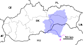  Current and watershed of the Sajó River in Slovakia and Hungary | |
| Location | |
| Countries | Slovakia and Hungary |
| Physical characteristics | |
| Source | |
| • location | Stolica Mountains |
| • elevation | 1,229 m (4,032 ft) |
| Mouth | |
• location | Tisza |
• coordinates | 47.9437°N 21.1142°E |
| Length | 229.4 km (142.5 mi) |
| Basin size | 12,708 km2 (4,907 sq mi) 12,869.6 km2 (4,969.0 sq mi)[1] |
| Discharge | |
| • location | Tiszaújváros, Hungary (near mouth) |
| • average | 70 m3/s (2,500 cu ft/s) 78.623 m3/s (2,776.5 cu ft/s)[2] |
| Discharge | |
| • location | Miskolc (Basin size: 6,245.8 km2 (2,411.5 sq mi)[3] |
| • average | 35.087 m3/s (1,239.1 cu ft/s)[4] |
| Discharge | |
| • location | Bánréve (Basin size: 3,204.7 km2 (1,237.3 sq mi)[5] |
| • average | 20.55 m3/s (726 cu ft/s)[6] |
| Basin features | |
| Progression | Tisza→ Danube→ Black Sea |
| Tributaries | |
| • left | Takta, Hernád, Bódva |
| • right | Rima, Szinva |
Its length is 229 km, of which 110 km is in Slovakia. Its source is in the Stolica Mountains range of the Slovak Ore Mountains. It flows through the Slovak town Rožňava and the Hungarian city Miskolc. In Hungary it flows through the county of Borsod-Abaúj-Zemplén. It flows into the River Tisza near Tiszaújváros. Its main tributaries are the Bodva and the Hornád.
Also known for Battle of the Sajó River from 11 April 1241 between the Mongol Empire and the Kingdom of Hungary.
Etymology
The origin of the name is the subject of scholar discussions. Hungarian linguists and historians suggested the derivation from the Hungarian sojó, só folyó (salt water, river) already in the 19th century.[7] Newer theories associate the name with sió referring to fast streams. According to Slovak linguists the name is pre-Hungarian (Slaná: salt river) and most likely not associated with the salinity but with the salt road existing already in times of Great Moravia. The supporters argue by numerous Slavic toponyms in the river basin and by local names related to soľ (salt) and Moravia like Moravce, Soľár, Solišče, Soľka, Soľník, Morava (according to this interpretation the Hungarian name is a later translation).[8]
References
- "Rivers Network". 2020.
- "Rivers Network". 2020.
- "Rivers Network". 2020.
- "Rivers Network". 2020.
- "Rivers Network". 2020.
- "Rivers Network". 2020.
- Krško, Jaromír (2013). "Rudolf Odraz multietnicity karpatského regiónu v slovenskej hydronymii". In Žeňuch, Peter; Uzeňova, Elena; Žeňuchová, Katarína (eds.). Jazyk a kultúra na Slovensku v slovanských a neslovanských súvislostiach (in Slovak). Bratislava: Slavistický ústav J. Stanislava SAV, Slovenský komitét slavistov a Zemplínske múzeum v Michalovciach. p. 71. ISBN 978-80-89489-11-4.
- Krško, Jaromír (2009). "Rudolf Krajčovič: Živé kroniky slovenských dejín skryté v názvoch obcí a miest - recenzia". Acta Onomastica (in Slovak). Praha: Ústav pro jazyk český AV ČR (L): 204–209. ISSN 1211-4413.
Hydrography of Slovakia | ||||||||||||
|---|---|---|---|---|---|---|---|---|---|---|---|---|
| Rivers |
|  | ||||||||||
| Lakes |
| |||||||||||
| Reservoirs |
| |||||||||||
| River islands | ||||||||||||
Authority control | |
|---|---|
| General |
|
| National libraries | |
This Borsod-Abaúj-Zemplén location article is a stub. You can help Wikipedia by expanding it. |
На других языках
[de] Sajó
Sajó (ungarisch) bzw. Slaná (slowakisch; deutsch selten die Salz, Salza oder Salzbach) ist ein etwa 230 km langer Fluss in der mittleren Slowakei und im nordöstlichen Ungarn. Er fließt in südöstlicher Richtung zur Theiß – die den Großteil Ungarns und Rumäniens entwässert – und nimmt unter den slowakischen Flüssen etwa den fünften Rang ein (unter jenen von Ungarn einen geringeren).- [en] Sajó
[es] Sajó
El Sajó (en húngaro; en eslovaco, Slaná) es un río en Hungría y Eslovaquia. Su longitud es de 229 km, de los cuales 110 km están en Eslovaquia. Su fuente se encuentra en las montañas del Montes Metálicos Eslovacos, en las Stolické vrchy ("montañas de Stolica"), en la pendiente septentrionale de Stolica, su cumbre el más alto (1476 m). Fluye a través de la ciudad eslovaca de Rožňava y la húngara de Miskolc. En Hungría fluye por el condado de Borsod-Abaúj-Zemplén. Fluye al río Tisza cerca de Tiszaújváros.[it] Sajó
Il Sajó (così in ungherese) o Slaná (così in slovacco) è uno dei fiumi più lunghi della Slovacchia meridionale e dell'Ungheria nord-orientale, è inoltre uno dei maggiori affluenti del Tibisco.[ru] Шайо (река)
Шайо или Сла́на (словацк. Slaná, венг. Sajó, нем. Salz, в переводе «Солёная») — река в Словакии и Венгрии, приток Тисы. Относится к бассейну Дуная.Другой контент может иметь иную лицензию. Перед использованием материалов сайта WikiSort.org внимательно изучите правила лицензирования конкретных элементов наполнения сайта.
WikiSort.org - проект по пересортировке и дополнению контента Википедии