geo.wikisort.org - Mountains
The Slovak Ore Mountains (Slovak: Slovenské rudohorie [ˈslɔʋenskeː ˈrudɔɦɔrɪe], Hungarian: Gömör–Szepesi-érchegység, German: Slowakisches Erzgebirge or Zips-Gemer-Erzgebirge) are an extensive mountain range within the Carpathian Mountains, located mostly in Slovakia's Spiš and Gemer region, with a small part in northern Hungary.[1] It is the largest mountain range in Slovakia. Geomorphologically, the Slovak Ore Mountains belong to the Inner Western Carpathians.
| Slovak Ore Mountains | |
|---|---|
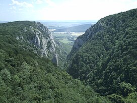
 Zadiel canyon in the Slovak Karst | |
| Highest point | |
| Peak | Stolica |
| Elevation | 1,476 m (4,843 ft) |
| Geography | |
 | |
| Range coordinates | 48°45′00″N 20°15′00″E |
| Parent range | Inner Western Carpathians |

The mountains are bordered by Zvolen in the west, Košice in the east, the rivers Hron and Hornád in the north, and the Juhoslovenská kotlina and Košice Basin (Košická kotlina) in the south. The region includes the Domica Cave (jaskyňa Domica), one of the largest caves in Europe, Zádiel canyon and Krásna Hôrka Castle.
Subdivision
Geomorphologically, the Slovak Ore Mountains are grouped within the Inner Western Carpathians. The mountains do not have a central ridge - they consist of several independent sections, geomorphological regions:[2]
- Vepor Mountains (Veporské vrchy)
- Spiš-Gemer Karst (Spišsko-gemerský kras)
- Stolica Mountains (Stolické vrchy)
- Revúca Highlands (Revúcka vrchovina)
- Volovec Mountains (Volovské vrchy)
- Black Mountain (Čierna hora)
- Rožňava Basin (Rožňavská kotlina)
- Slovak Karst (Slovenský kras) and Aggtelek Karst (Hungarian: Aggteleki-karszt; lies in northern Hungary)
Characteristics
Basic data:
- highest peak: Stolica, 1,476 m AMSL
- length: app. 140 km
- width: app. 40 km
- area: app. 4000 km2
Since this is a very extensive geomorphological unit, no general characterization is appropriate. The geomorphological structure is varied and has crystalline, Mesozoic and volcanic rocks.
Since time immemorial, especially in the early modern period, the mountains were, as the name suggests, heavily mined but are not any more.
Protected areas
Slovenské rudohorie contains the Muránska planina National Park, Slovak Karst National Park and Slovak Paradise National Park.
References
- Lonely Planet Czech & Slovak Republics Lisa Dunford, Brett Atkinson, Neil Wilson - 2007 - Page 423 "Do all this and more, among the fanciful underworld formations of the Slovak Karst (Slovensky kras). This region of limestone canyons and caves lies at the eastern end of Slovenské rudohorie (the Slovak Ore Mountains), a major range that reaches the border with Hungary. Its most spectacular landscapes are within the 440-sq-km Slovak Karst National Park, promoted to a Unesco World Heritage site in 1995. The region's highlights include Domica Cave (Domica jaskyňa), said to be one of the biggest caves in the world, Zadielska canyon near the Hungarian border, and the dramatic Krásna Hôrka Castle."
- Mazúr, E., Lukniš M., 1986: Geomorfologické členenie SSR a ČSSR. Časť Slovensko. Slovenská kartografia, Bratislava
| Wikimedia Commons has media related to Slovak Ore Mountains. |
На других языках
[de] Slowakisches Erzgebirge
Das Slowakische Erzgebirge (slowakisch Slovenské rudohorie) ist das flächenmäßig größte Gebirge der Slowakei und liegt im Verlauf der Westkarpaten. Es schließt südlich an die Niedere Tatra an und überdeckt den Großteil der südlichen Mittelslowakei. Seine Höhen sind geringer als jene der Tatra, doch wirtschaftlich ist es durch seine Erz- und andere Lagerstätten bedeutsam. Viele Abbaue sind heute allerdings stillgelegt.- [en] Slovak Ore Mountains
[es] Montes Metálicos eslovacos
Los Montes Metálicos eslovacos (eslovaco: Slovenské rudohorie, húngaro: Gömör-Szepesi-érchegység, alemán: Slowakisches Erzgebirge o Zips-Gemer-Erzgebirge) son una extensa cadena montañosa dentro de los Cárpatos, situada principalmente en la región eslovaca de Spiš y Gemer, con una pequeña parte en el norte de Hungría.[1] Es la mayor cadena montañosa de Eslovaquia. Geomorfológicamente, los Montes Metálicos eslovacos pertenecen a los Cárpatos Occidentales Interiores.[fr] Monts Métallifères slovaques
Les monts Métallifères slovaques (en slovaque Slovenské rudohorie), appartenant aux Carpates occidentales, constituent la chaîne de montagne la plus étendue de Slovaquie. Ils s'effacent au sud des Tatras inférieures et recouvrent pratiquement la moitié sud de la Slovaquie centrale. D'une altitude inférieure à celle des Tatras, ils revêtent pour le pays une plus grande importance, de par leurs richesses naturelles et les mines (dont plusieurs sont toutefois abandonnées aujourd'hui).[it] Monti Metalliferi Slovacchi
I Monti Metalliferi Slovacchi (in slovacco Slovenské rudohorie) sono una catena montuosa della Slovacchia appartenente ai Carpazi.[ru] Словацкие Рудные горы
Слова́цкие Ру́дные го́ры[1] (словацк. Slovenské rudohorie) — горный регион в спишской Словакии, расположенный к востоку от Зволена и к западу от Кошиц. С севера ограничен реками Грон и Горнад. Протяжённость гор составляет около 140 км, ширина — 40 км, площадь — 4000 км². Высшая точка — гора Столица (1477 м).Другой контент может иметь иную лицензию. Перед использованием материалов сайта WikiSort.org внимательно изучите правила лицензирования конкретных элементов наполнения сайта.
WikiSort.org - проект по пересортировке и дополнению контента Википедии
