geo.wikisort.org - Mountains
The Southern Carpathians (also known as the Transylvanian Alps;[1][2] Romanian: Carpații Meridionali [karˈpat͡sij ˌmeridi.oˈnalʲ]; Hungarian: Déli-Kárpátok) are a group of mountain ranges located in southern Romania.[3] They cover the part of the Carpathian Mountains located between the Prahova River in the east and the Timiș and Cerna Rivers in the west. To the south they are bounded by the Balkan mountain range in eastern Serbia.
| Southern Carpathians | |
|---|---|
| Romanian: Carpații Meridionali | |
 Negoiu Peak (2535m) | |
| Highest point | |
| Peak | Moldoveanu |
| Elevation | 2,544 m (8,346 ft) |
| Coordinates | 45°30′N 24°15′E |
| Geography | |
 Location of the Southern Carpathians in Romania
| |
| Country | Romania |
| Parent range | Carpathians |
| Geology | |
| Orogeny | Alpine orogeny |
| Age of rock | Mostly Triassic |
Heights

The Southern Carpathians are the second highest group of mountains in the Carpathian Mountain range (after Tatra), reaching heights of over 2,500 meters. Although considerably smaller than the Alps, they are classified as having an alpine landscape. Their high mountain character, combined with great accessibility, makes them popular with tourists and scientists.
The highest peaks are:
- Moldoveanu Peak, 2,544 metres – Făgăraș Mountains
- Negoiu, 2,535 metres – Făgăraș Mountains
- Parângu Mare, 2,519 metres – Parâng Mountains
- Omu Peak 2,514 metres – Bucegi Mountains
- Peleaga, 2,509 metres – Retezat Mountains
Despite the heights, some of the most accessible passages in the Carpathians in Romania are along the rivers, which cross the mountain range (the Olt River) or form wide valleys (along the Prahova River Valley or along the Jiu River Valley).
Geology
The South Carpathians represent an intricate pile of tectonic nappes, overthrusted from west eastwards during the Austrian (Middle Cretaceous) and Laramian paroxysmal phases, corresponding to various plate fragments. The napes are (from west eastwards): the Supragetic, Getic, Severin and Danubian Units. The Getic Nappe was identified by Murgoci (1905),[4] while the general understanding over the Alpine structure of the South Carpathians was later refined by Codarcea (1940),[5] Codarcea et al. (1961),[6] Năstăseanu et al. (1981),[7] Săndulescu (1984),[8] Săndulescu and Dimitrescu (2004),[9] and Mutihac (1990).[10] The first to apply the global tectonics concepts for the Romanian Carpathians were Rădulescu and Săndulescu (1973).[11]
The Supragetic, Getic Nappes as well as the Danubian Units represent units with both a metamorphic basement and a sedimentary cover, while the Severin Nappe includes only a sedimentary sequence. The Getic Nappe and the Danubian Units sediments include a Palaeozoic sequence (Upper Carboniferous, Lower Permian) and a Mesozoic sequence (Lowermost Jurassic – Middle Cretaceous). The Supragetic Nappe comprises mainly metamorphosed rocks (gneisses, micashists), while the Severin Nappe includes only Upper Jurassic – Lower Cretaceous sediments.
Mountain ranges
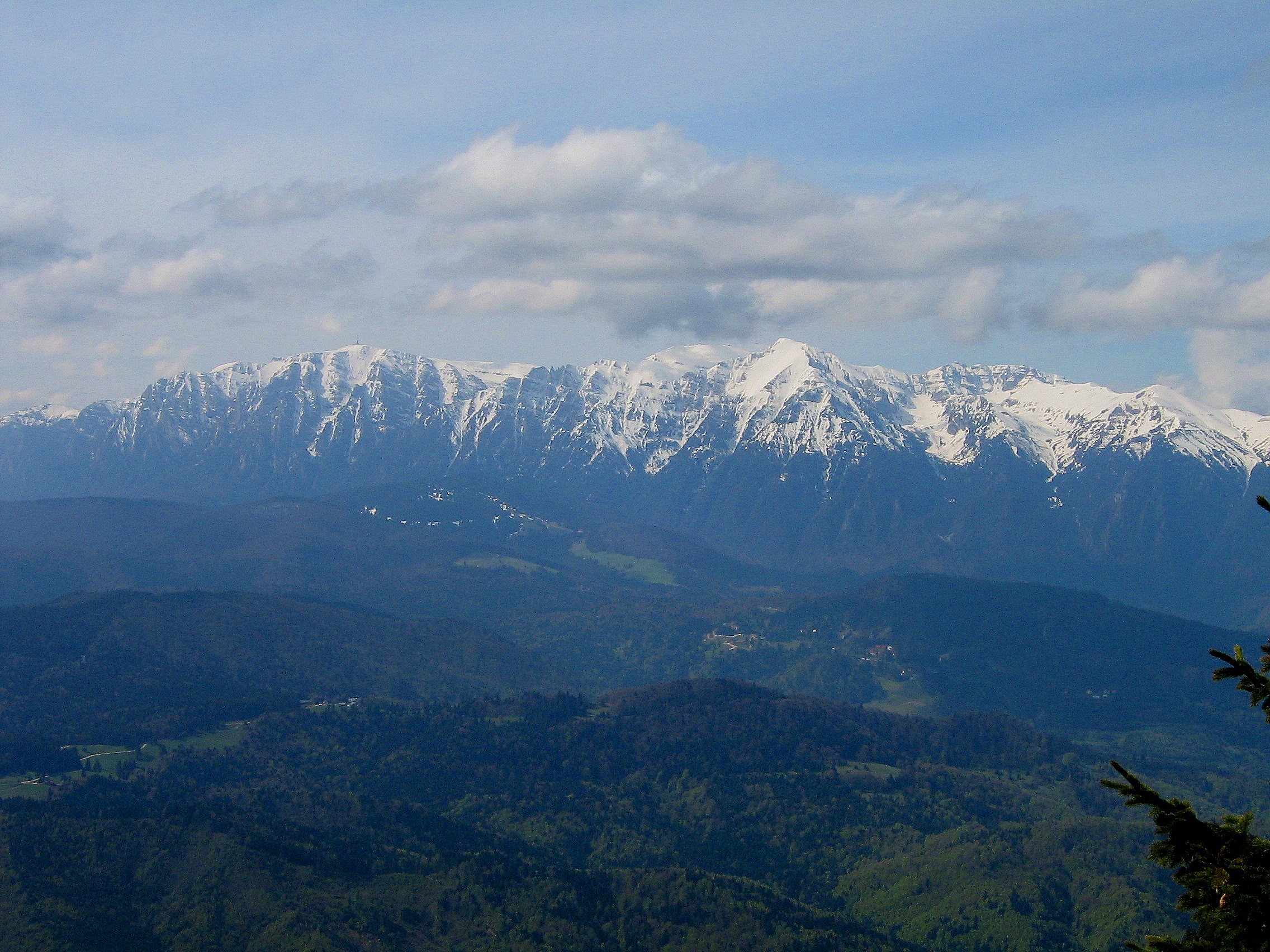
![Moldoveanu peak (2544 m) is the highest in Romania and one of the highest peaks of the Carpathians[12]](http://upload.wikimedia.org/wikipedia/commons/0/0b/Rumunia_06_147.jpg)

From east to west, four mountain groups can be identified, separated by different river valleys.
- Bucegi Mountains group – between the Prahova and Dâmbovița Rivers.
- Bucegi Mountains (Munții Bucegi)
- Piatra Craiului (literally: "Rock of the King")
- Leaotă Mountains (Munții Leaotă)
- Făgăraș Mountains group – between the Dâmbovița River and the Olt River.
- Făgăraș Mountains (Munții Făgărașului)
- Iezer Mountains (Munții Iezer; literally: "Mountains of the Deep Lake")
- Cozia Mountains (Munții Cozia)
- Parâng Mountains group – between the Olt River and the Jiu River.
- Parâng Mountains (Munții Parâng)
- Șureanu Mountains (Munții Șureanu/M. Sebeșului)
- Cindrel Mountains (Munții Cindrel/M. Cibinului)
- Lotru Mountains (Munții Lotrului; literally: "Mountains of the Thief")
- Căpățână Mountains (Munții Căpățânii; literally: "Mountains of the Skull")
- Retezat-Godeanu Mountains group – between the Jiu River and the Timiș and Cerna Rivers.
- Retezat Mountains (Munții Retezat; literally: "Hewed Mountains")
- Godeanu Mountains (Munții Godeanu)
- Vâlcan Mountains (Munții Vâlcan)
- Mehedinți Mountains (Munții Mehendinți)
- Cerna Mountains (Munții Cernei)
- Țarcu Mountains (Munții Țarcu; literally: "Pen Mountains").
- Poiana Ruscă Mountains
The first two groups are steepest on the North side, and the last two are steepest on the South side.[citation needed]
Gallery
 Bucegi as seen from Postavaru massif
 Caraiman Cross on mountain top
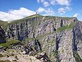 Coștila 400 meters high wall
 View from Bușteni
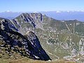 Scara summit in Bucegi Mountains
 The Sphinx of Bucegi
 Piatra Craiului Mountains
 Jepii Mici Peak in Bucegi Mountains
 Lake Bâlea in Făgăraș Mountains
 Challenging hiking trail
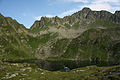 Podragu Lake
 Transfăgărășan alpine road
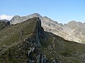 Regular footpath in Făgăraș Mountains
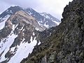 Custura Sărătii (in the center of the photo)
 La Zaplaz landmark
 Piatra Craiului ridge in winter
 Landscape in Parâng Mountains
 Parâng alpine scenery
 Shelter in Parâng mountains
 One of many Parâng glacial lakes
 Glacial lakes in the Retezat Mountains
 Bucura Peak in the distance
 Sunset on Retezat Peak
 Salvamont shelter in Retezat
 Waterfall in Retezat National Park
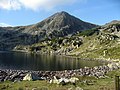 Bucura Lake


See also
- Romanian Carpathians
- Divisions of the Carpathians
- Iron Gates, at the South-Western end
- Prahova Valley, at the Eastern end
References
- Comănescu, Laura, & Alexandru Nedelea. 2016. Geomorphosites Assessments of the Glacial and Periglacial Landforms from Southern Carpathoans. In: Maria Radoane & Alfred Vespremeanu-Stroe (eds.), Landform Dynamics and Evolution in Romania, pp. 215–248. Cham: Springer, p. 202.
- Quinn, Joyce Ann, & Susan L Woodward. 2015. Earth's Landscape: An Encyclopedia of the World's Geographic Features. Santa Barbara, CA: ABC-CLIO, p. 138.
- Carpathians.pl Archived 2010-04-06 at the Wayback Machine
- Murgoci, G.M., 1905. Sur l'existence d'une grande nappe de recouvrement dans les Carpathes meridionales. C. R. Acad. Sci., 7: 31.
- Codarcea , A., 1940. Vues nouvelles sur la tectonique du Banat meridional et du Plateau de Mehedinți. D. S. Inst. Geol. Rom., 20: 1–74.
- Codarcea, A., Răileanu, G., Pavelescu, L., Gherasi, N., Năstăseanu, S., Bercia, I. and Mercus, D., 1961. Guide des excursions. Carpates Meridionales, București, 130 pp.
- Năstăseanu, S., Bercia, I., Iancu, V., Vlad and Hârtopanu, I., 1981. The structure of the South Carpathians (Mehedinți – Banat Area). Guidebooks series, 22. IGR, Bucuresti, 3–100 pp.
- Săndulescu, M., 1984. Geotectonica României. Editura Tehnică, București, 336 pp.
- Săndulescu, M. and Dimitrescu, R., 2004. Geological structure of the Romanian Carpathians, Florence, 48 pp.
- Mutihac, V., 1990. Structura geologică a teritoriului României. Editura Tehnică, Bucharest, 419 pp.
- Rădulescu, D. and Săndulescu, M., 1973. The plate-tectonics concept and the geological structure of the Carpathians. Tectonophysics, 16: 155–161.
- "Moldoveanu : Climbing, Hiking & Mountaineering : SummitPost". www.summitpost.org. Retrieved 2020-10-07.
External links
Divisions, Groups, and Ranges of the Carpathian Mountains | ||||||
|---|---|---|---|---|---|---|
| Western Carpathians |
|  | ||||
| Eastern Carpathians |
| |||||
| Southern Carpathians | ||||||
| Western Romanian Carpathians | ||||||
| Serbian Carpathians | ||||||
| Adjacent regions |
| |||||
| Grouping by country |
| |||||
Authority control | |
|---|---|
| General |
|
| National libraries | |
| Other | |
На других языках
[de] Transsilvanische Alpen
Die Transsilvanischen Alpen (rum. Carpații Meridionali) sind ein Teil der Karpaten in Rumänien und werden oft auch Südkarpaten genannt. Die Höhe erreicht mit dem Moldoveanu bis zu 2544 Meter. Das Gebirge trennt Siebenbürgen (nördlich) von der Walachei (südlich). Den Transsilvanischen Alpen schließt sich südwestlich das Banater Gebirge an, das als Teil der Karpaten bis nach Serbien reicht. Die östliche Begrenzung ist der Predeal-Pass.- [en] Southern Carpathians
[es] Cárpatos meridionales
Los Cárpatos meridionales o Alpes de Transilvania (rumano, Carpații Meridionali; alemán, Transsilvanischen Alpen; húngaro, Déli-Kárpátok) son un grupo de sierras que separan la Rumanía central y meridional, por un lado, y Serbia, por el otro lado.[1] Abarcan la parte de los Cárpatos que están ubicados entre el río Prahova en el este y los ríos Timiș y Cerna en el oeste. Al sur están limitados por los Balcanes de Serbia.[fr] Alpes de Transylvanie
Les Alpes de Transylvanie (dénomination internationale) ou Carpates méridionales (Carpații Meridionali, dénomination roumaine) sont un groupe de montagnes qui se trouvent entre le centre et le sud de la Roumanie[1]. C’est la partie des Carpates qui se trouve entre la rivière Prahova à l’est, et les rivières Timiș et Cerna à l’ouest. On trouve parfois le nom d’Alpes transylvaines, et on y inclut parfois par commodité de langage, des massifs voisins à l’est (dans le coude des Carpates) et à l’ouest (monts du Banat : dans ce cas, au sud-ouest, ils sont limités par les Balkans de Serbie).[it] Alpi Transilvaniche
Le Alpi Transilvaniche (in rumeno Carpații Meridionali), anche chiamate Carpazi Meridionali, sono un gruppo di catene montuose che dividono la Romania centrale e meridionale segnando il confine fra Valacchia e Transilvania. Coprono la parte dei Monti Carpazi che è situata fra il fiume Prahova a oriente e i fiumi Timiș e Cerna a occidente.[ru] Южные Карпаты
Южные Карпаты, или Трансильванские Альпы (рум. Carpatii Meridionali) — крайняя южная часть горной системы Карпат. Расположены полностью на территории республики Румыния (исторические области Валахия, Мунтения, Олтения, Банат, Трансильвания). Основой южно-карпатский хребет тянется с запада на восток на протяжении порядка 300 км. Южные Карпаты — это наиболее высокая и наиболее сейсмичная часть Карпатской горной системы. Высочайшая точка — гора Молдовяну высотой 2544 м.Другой контент может иметь иную лицензию. Перед использованием материалов сайта WikiSort.org внимательно изучите правила лицензирования конкретных элементов наполнения сайта.
WikiSort.org - проект по пересортировке и дополнению контента Википедии