geo.wikisort.org - Mountains
The North Hungarian Mountains (Hungarian: Északi-középhegység), sometimes also referred to as the Northeast Hungarian Mountains, Northeast Mountains, North Hungarian Highlands, North Hungarian Mid-Mountains or North Hungarian Range,[1][2] is the northern, mountainous part of Hungary. It forms a geographical unity with the Mátra-Slanec Area, the adjacent parts of Slovakia. It is a separate geomorphological area within the Western Carpathians.
| North Hungarian Mountains | |
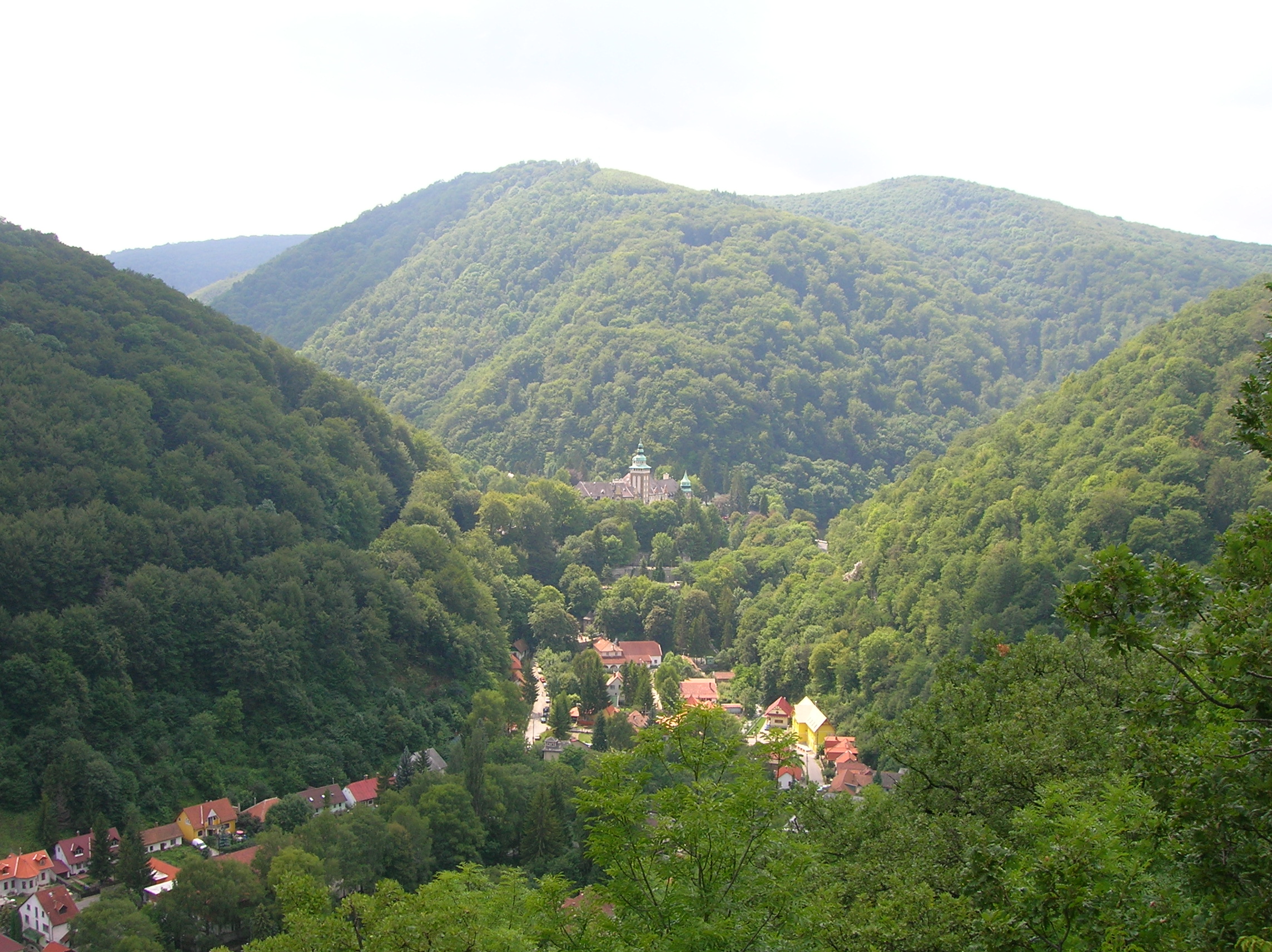 | |
| The view of the valley of Lillafüred in the Bükk mountains. Although this is not the highest part of the county, the landscape is typical of Hungarian mountains. | |
| Location | Northern Hungary, southern Slovakia |
| Territory | 13,000 km² (in Hungary) |
| Highest point | Kékes (Hungary) 1014 m Šimonka (Slovakia) 1092 m |
| Terrain | lower and moderately high mountains |
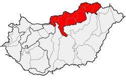
The mountains run along the northeastern border of Hungary as well as eastern parts of the Hungarian–Slovak border in broadband from the Danube Bend to the town of Prešov.
Subdivisions
The area consists of the following geomorphological units:
- Börzsöny [3] (Hungarian: Börzsöny + Burda (SK)
- Gödöllő Hills (Hungarian: Gödöllői-dombság)
- Cserhát[3]
- Karancs-Medves area + Cerová Highlands (SK)
- Mátra[3] (Hungarian: Mátra)
- Bükk[3] (Hungarian: Bükk or "Bükk hegység" – literally Beech (Mountains))
- Zemplén Mountains or Tokaj Mountains (Hungarian: Zempléni-hegység, Tokaji-hegység)
Ranges of the adjacent Mátra-Slanec Area in Slovakia:
- Slanec Mountains (Slovak: Slanské vrchy)
- Zemplín Mountains (Slovak: Zemplínske vrchy)
Description
The North Hungarian Mountains begin with the mountain range of Börzsöny, adjacent to the Danube Bend, where it meets the Transdanubian Mountains.
The Börzsöny range is about 600 km² in area, and mainly of volcanic origin. The highest peak is the Csóványos (938 m).
The next range towards the east is the Cserhát, with the same geological composition as the Börzsöny. Erosion here was more severe: these are mere hills and comprise the lowest part of the North Hungarian Mountains. The highest point is Naszály (654 m).
Kékes, the country's highest peak at 1014 meters, is located in the next range, Mátra. However, the range's average height is only 600 meters, less than that of the neighboring Bükk. Mátra is also of volcanic origin.

The Bükk is a limestone range; it has the highest average height in Hungary. It is rich in caves, some of which were inhabited in ancient times.
The Aggtelek Karst area is a geologic formation spanning the Hungarian-Slovakian border, and the reason for the Caves of Aggtelek Karst and Slovak Karst World Heritage Site, and the Hungarian Aggtelek National Park. Hungary's a most popular cave, the Baradla, is located there.
The Zemplén Mountains are again of volcanic origin; the soil's high-quality favors viticulture.
Natural resources
- brown coal
- fertile soil
- forestry
- lignite
- limestone
- viticulture
National parks
- Aggtelek National Park (established in 1985)
- Bükk National Park (established in 1976)
- Danube-Ipoly National Park (established in 1997)

Protected areas
- Hollókő (since 1977)
- East Cserhát (since 1989)
- Karancs-Medves (since 1989)
- Mátra (since 1985)
- Tarnavidék (since 1993)
- Lázbérc (since 1975)
- Tokaj-Bodrogzug (since 1986)
- Zemplén (since 1984)
Images


See also
- Bükk
- Carpathians
- Geography of Hungary
- Mátra
- Tokaj-Hegyalja (part of Zemplén Mountains)
References
- Gábor Gercsák (2002). "Hungarian geographical names in English language publications" (PDF). Studia Cartologica. Eötvös Loránd University. Archived from the original (PDF) on 20 March 2012. Retrieved 30 April 2011.
- Gábor Gercsák (2005). "Magyar tájnevek Angol fordítása" (PDF). Fasciculi Linguistici / Series Lexicographica (in Hungarian). Eötvös Loránd University. Archived from the original (PDF) on 20 March 2012. Retrieved 30 April 2011.
- Regional Map Series of Hungary Archived 2007-10-07 at the Wayback Machine
Geographical regions of Hungary | ||
|---|---|---|
| West-Hungarian Borderland |
|  |
| Little Hungarian Plain |
| |
| Transdanubia |
| |
| Transdanubian Mountains |
| |
| Transdanubian Hills |
| |
| North Hungarian Mountains |
| |
| Great Hungarian Plain |
| |
Divisions, Groups, and Ranges of the Carpathian Mountains | ||||||
|---|---|---|---|---|---|---|
| Western Carpathians |
|  | ||||
| Eastern Carpathians |
| |||||
| Southern Carpathians | ||||||
| Western Romanian Carpathians | ||||||
| Serbian Carpathians | ||||||
| Adjacent regions |
| |||||
| Grouping by country |
| |||||
На других языках
[de] Nördliches Ungarisches Mittelgebirge
Das Nördliche Mittelgebirge ist eine Gebirgsregion Ungarns nördlich und östlich des Donauknies bei Visegrád mit Höhen bis zu 1000 m ü. Adria. Es zählt zu den Karpaten. Nach der geomorphologischen Gliederung der Karpaten ist das Nordungarische Mittelgebirge identisch mit dem Mátra-Slanec-Gebiet und gehört zur Subprovinz Innere Westkarpaten der Provinz Westkarpaten.- [en] North Hungarian Mountains
[fr] Massif du Nord (Hongrie)
Le massif du Nord (hongrois : Északi-középhegység, massif du Nord, prononcé [ˈeːsɒki ˈkøzeːphɛcʃeːg])), appelé région de Mátra-Slanec (slovaque : Matransko-Slanská oblasť) en Slovaquie, est un massif situé au Nord de la Hongrie, entre Budapest et la Slovaquie, sur les contreforts des Carpates.[it] Rilievi precarpatici settentrionali
I rilievi precarpatici settentrionali (in ungherese Északi-középhegység) sono una catena montuosa a cavallo fra l'Ungheria settentrionale e la Slovacchia. Essa forma una unità geografica unica con la zona slovacca di Mátra-Slanec. Essi costituiscono il bordo meridionale dei Carpazi Occidentali Interni.[ru] Северовенгерские горы
Северовенгерские горы (иногда называемые Северо-Восточными венгерскими горами, Северо-Восточными горами, Северовенгерским плоскогорьем, Северовенгерской возвышенностью венг. Északi-középhegység)[1][2] — северная гористая часть Венгрии. Она формирует единый географический регион с прилегающей к Венгрии словацкой Матранско-Сланской областью. Вместе они образуют отдельную единую геоморфологическую область внутри Западных Карпат. Горы простираются вдоль всей Северо-Восточной Венгрии, по восточной части венгерско-словацкой границы широкой полосой от Дунайской излучины до города Прешов.Другой контент может иметь иную лицензию. Перед использованием материалов сайта WikiSort.org внимательно изучите правила лицензирования конкретных элементов наполнения сайта.
WikiSort.org - проект по пересортировке и дополнению контента Википедии