geo.wikisort.org - Mountains
The Zemplín Mountains is a small mountain range in southeastern Slovakia, geologically part of the Mátra-Slanec Area of the Inner Western Carpathians.
This article does not cite any sources. (March 2019) |
- not to be confused with the nearby Zemplén Mountains
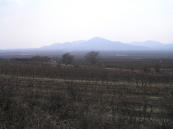
The range of about 101 square kilometers is near the border of Hungary and its Tokaj wine region. The highest mountain of the range is Rozhladňa (469 meters). An important river is Roňava which also forms the border with Hungary; another river with its headwaters here is the Bodrog.
Wikimedia Commons has media related to Zemplínske vrchy.
Authority control | |
|---|---|
| General |
|
| National libraries | |
На других языках
[de] Zemplínske vrchy
48.4521.716666666667469- [en] Zemplín Mountains
[ru] Земплинске-Врхи
Земплинске-Врхи (словацк. Zemplínske vrchy) — небольшой горный массив в восточной Словакии на территории Земплина. Относится к Матранско-Сланской области Внутренних Западных Карпат. Наивысшая точка — гора Розглядня, 470 м.Текст в блоке "Читать" взят с сайта "Википедия" и доступен по лицензии Creative Commons Attribution-ShareAlike; в отдельных случаях могут действовать дополнительные условия.
Другой контент может иметь иную лицензию. Перед использованием материалов сайта WikiSort.org внимательно изучите правила лицензирования конкретных элементов наполнения сайта.
Другой контент может иметь иную лицензию. Перед использованием материалов сайта WikiSort.org внимательно изучите правила лицензирования конкретных элементов наполнения сайта.
2019-2026
WikiSort.org - проект по пересортировке и дополнению контента Википедии
WikiSort.org - проект по пересортировке и дополнению контента Википедии