geo.wikisort.org - Mountains
Gerecse is a mountain range in north-western Hungary, [clarification needed] that belongs to the Transdanubian Mountains
| Gerecse | |
|---|---|
 | |
| Highest point | |
| Peak | Nagy-Gerecse |
| Elevation | 634 m (2,080 ft) |
| Dimensions | |
| Area | 850 km2 (330 sq mi) |
| Geography | |
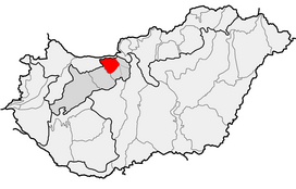 Location of Gerecse Mountains within physical subdivisions of Hungary
| |
| Country | Hungary |
| County | Komárom-Esztergom County |
| Range coordinates | 47°38.6′N 18°24.3′E |
| Geology | |
| Orogeny | Transdanubian Mountains |
| Type of rock | chalk, limestone |
Geography
The range lies in the Central Transdanubian region and connects Vértes Hills with Pilis Mountains in Komárom-Esztergom County, between the town of Tatabánya and the Danube River. Gerecse occupies an area of 850 km2 (20,300 ha). The highest point is Nagy-Gerecse at 634 m.[1] The main rock is limestone and chalk.
Biology
Deciduous oak forests cover the lower slopes, with submontane species of Quercus, Carpinus, Fagus, and at higher altitudes karst scrub. The area is 70% forest, 5% scrubland, 10% grassland, and 15% artificial landscapes.[1] Yearly sunshine duration is around 1,980 hours. The average annual temperature above the height of 350 meters is 9.5 C (in January -2,8 C). The average annual precipitation is 640 millimeters.
Gallery
 Farkasvölgy (Wolf-valley)
 Forest in the Gerecse
 The monument of the Battle of Pusztamarót, 1526
 Gerecse near Péliföldszentkereszt


See also
- Transdanubian Mountains
- Geography of Hungary
References
- "Gerecse mountains". HungarianBirdwatching.com. 2004. Archived from the original on 2011-07-12. Retrieved 2010-11-22.
External links
- http://www.kektura.click.hu/keret.cgi?/OKT/szovegek/angol/tour_05.htm Archived 2016-03-03 at the Wayback Machine
- gerecse.lap.hu (in Hungarian)
- Gerecse (in Hungarian)
- Gerecse barlangjai (in Hungarian)
- Gerecsei Tájvédelmi Körzet (in Hungarian)
Geographical regions of Hungary | ||
|---|---|---|
| West-Hungarian Borderland |
|  |
| Little Hungarian Plain |
| |
| Transdanubia |
| |
| Transdanubian Mountains |
| |
| Transdanubian Hills |
| |
| North Hungarian Mountains |
| |
| Great Hungarian Plain |
| |
На других языках
[de] Gerecse-Gebirge
Das Gerecse-Gebirge, auf deutsch auch Geißgebirge genannt, gehört dem westlichsten Teil des Dunazug-Berglands im Ungarischen Mittelgebirge an. Das Karstgebirge umfasst ein Gebiet von 850 km² und ist durchschnittlich 400 m hoch. Der höchste Gipfel ist mit 634 m der Nagy-Gerecse („Großer Geiß“).- [en] Gerecse Mountains
[fr] Gerecse
Les monts de Gerecse (hongrois : Gerecse hegység, monts de Gerecse, prononcé [ˈgɛɾɛtʃɛ ˈhɛcʃeːg]) sont un massif collinéen situé entre Esztergom et Tatabánya dans le massif de Transdanubie, à l'ouest des monts du Pilis. Le point culminant est le Nagy-Gerecse (634 m). La zone de protection paysagère de Gerecse s'étend à tout le massif.[it] Monti Gerecse
I Monti Gerecse (ungherese: Gerecse-hegység ) sono un'area collinare di modesta altezza che si trova in Ungheria nella parte settentrionale del Transdanubio.Другой контент может иметь иную лицензию. Перед использованием материалов сайта WikiSort.org внимательно изучите правила лицензирования конкретных элементов наполнения сайта.
WikiSort.org - проект по пересортировке и дополнению контента Википедии