geo.wikisort.org - Mountains
Mweelrea (/mwiːlˈreɪ/; from Irish Cnoc Maol Réidh 'bald hill with the smooth top')[4] at 814 metres (2,671 ft), is the 26th-highest peak in Ireland on the Arderin scale,[5] and the 34th-highest peak on the Vandeleur-Lynam scale.[6][7] Mweelrea is situated near the apex of a "horseshoe-shaped" massif that includes the peaks of Ben Lugmore and Ben Bury, and which is located between Killary Harbour and Doo Lough, in Mayo, Ireland.[7][8] Mweelrea is the provincial top for Connacht, and is noted for its southeastern cliff lined corries,[8][9] and its views.[10] The massif is called the Mweelrea Mountains or the Mweelrea Range.[3][9]
| Mweelrea | |
|---|---|
| Cnoc Maol Réidh; smooth bald hill | |
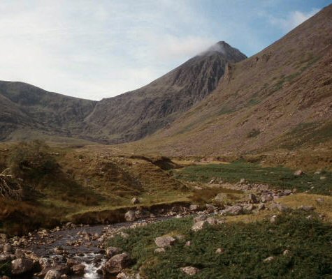
 Mweelrea and the corrie lake of Lough Bellawaum, viewed from Ben Lugmore in the east | |
| Highest point | |
| Elevation | 814 m (2,671 ft)[1] |
| Prominence | 779 m (2,556 ft)[1] |
| Listing | County top (Mayo), P600, 100 Highest Irish Mountains, Marilyn, Hewitt, Arderin, Simm, Vandeleur-Lynam |
| Coordinates | 53.63724°N 9.830358°W |
| Naming | |
| English translation | smooth bald hill |
| Language of name | Irish |
| Pronunciation | /mwiːlˈreɪ/ |
| Geography | |
 Mweelrea Location of Mweelrea in Ireland | |
| Location | County Mayo, Ireland |
| Parent range | Mweelrea Mountains |
| OSI/OSNI grid | L7898366810 |
| Topo map | OSi Discovery 37 |
| Geology | |
| Mountain type | Sandstone & conglomerate, ignimbrite bedrock[1] |
| Climbing | |
| Easiest route | "Silver Strand"[2] |
| Normal route | "The Ramp" (Lug More corrie)[3] |
Naming
Mweelrea is an anglicisation of the Irish: Cnoc Maol Réidh, which translates as "bald hill with the smooth top", which describes the profile of the mountain.[4]
Geology
The geology of what is known as the Mweelrea Formation is very different from that of the Twelve Bens, on the other side of Killary Harbour. At a summary level, the Mweelrea Formation consists of Ordovician period sandstones originally deposited on large alluvial fans, and distally‐equivalent alluvial plains and delta fans. Interbedded with these sandstones are tufts, being ash deposits from Ordovician period volcanos.[11][12]
Geography
Mweelrea, and its subsidiary peaks, form the southern half of the "horseshoe-shaped" massif of the Mweelrea Mountains, which are bounded by Killary Harbour, Ireland's deepest fjord, to the south, and Doo Lough to the north.[8][9]
The valley in the centre of this "horseshoe" is the townsland of Glenconnelly (Irish: Gleann Choinnile).[13] Two deep corries lie at the head of the Glenconnelly valley, below Mweelrea's southeast face; the southerly corrie contains Lough Lugaloughan, while the northerly corrie contains Lough Bellawaum; both are drained by the Sruhaunbunatrench River, which empties into the Bundorragha River, which itself flows into Killary Harbour.[9]
Mweelrea at 814 metres (2,671 ft), is the highest mountain in massif, and is the provincial top for Connacht.[8][9] Mweelrea's prominence of 779 metres (2,556 ft) qualifies it as a Marilyn, and it also ranks it as the 16th-highest mountain in Ireland on the MountainViews Online Database, 100 Highest Irish Mountains, where the minimum prominence threshold is 100 metres.[7][14]
Northeast of Mweelrea is Ben Bury (or Irish: Ucht an Chreagáin, meaning "breast of the little crag"; it is also known as "Oughty Craggy"), at 795 metres (2,608 ft), and whose prominence of 60 metres (200 ft) qualifies it as a Vandeleur-Lynam (it is the 43rd-highest Vandeleur-Lynam in Ireland).[7][9]
Further east around the "horseshoe" lies the long high summit ridge of Ben Lugmore (and its subsidiary peaks), that is only slightly lower than Mweelrea at 803 metres (2,635 ft), and its northeast face forms the headwall of the cliff-lined Lug More Irish: Coum Dubh corrie.[8][9]
Southwest of Mweelrea is the southern arm of the "horseshoe", which is both lower and less sustained than the northern side. It includes the Mweelrea SE Spur at 495 metres (1,624 ft) (sometimes called "point-495" in guidebooks), and finishes with the isolated Teevnabinnia (Irish: Taobh na Binne, meaning "side of the peak"), whose height is only 379 metres (1,243 ft), but whose prominence of 214 metres (702 ft) qualifies it as a Marilyn.[7][9] West of Mweelrea lie the County Mayo beaches of Uggool Beach and Silver Strand.
Recreation
Hill walking
As the highest mountain in Connacht, Mweelrea is climbed in "Four Peaks Challenge" formats, being the highest mountains in the four provinces of Ireland.[15]
The fastest and most straightforward way to summit Mweelrea is via the 8–kilometre 3-hour Silver Strand Route.[2]
A longer route is the 13-kilometre 6-hour round trip via the Lug More (or Irish: Coum Dubh) corrie and the valley of Glen Glencullin that take in the summits of Ben Bury and Ben Lugmore. A notable feature known as The Ramp is used, which crosses the headwall of this corrie at mid-way, from east to west in an upward slope; reaching the ridge of Ben Lugmore at a col with Ben Bury. While this route is direct, caution is advised in properly finding The Ramp, as the corrie has extensive cliffs.[3]
Mweelrea is also climbed as part of the 15-kilometre 6-7 hour Mweelrea Horseshoe, which is described by a notable Irish guidebook as one of "the top three" in Ireland.[8] The circuit starts and ends at the Delphi Mountain Resort, and takes in all the peaks of the massif of Mweelrea, including Ben Lugmore (and its subsidiary peaks), Ben Bury, Mweelrea and the Mweelrea SE Spur (or point 495-metres).[8][9]
Rock climbing
While the main rock-climbing on the Mweelrea massif is on the northeastern slopes of Ben Lugmore (see here), there are long Grade 1 and 2 scrambles on the northeastern slopes of Mweelrea/Ben Bury.[16]
Winter climbing
The Lough Bellawaum corrie, Mweelrea's northeastern corrie, also has a number of winter-climbs, the most notable of which are Blue Route (Grade II/III, 270 m), and Red Route (Grade III, 305 m).[17]
Gallery
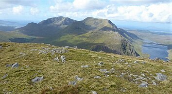 Mweelrea (back left), and Ben Lugmore (centre), viewed from the east on the summit of Ben Gorm
 Mweelrea and the corrie lake of Lough Bellawaum, as viewed from Ben Lugmore
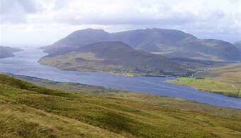 Mweelrea massif as viewed from Leenaun Hill, with Mweelrea (back left), Ben Lugmore (back, right) and Teevnabinnia (centre, front)
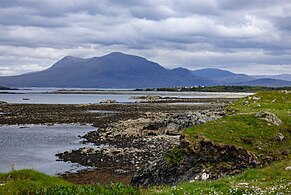 Mweelrea viewed from the south in Renvyle
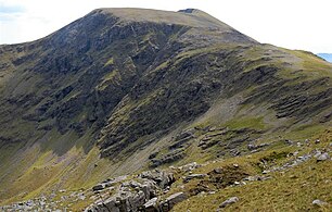 Mweelrea eastern summit ridge as viewed from Ben Bury


Bibliography
- Fairbairn, Helen (2014). Ireland's Best Walks: A Walking Guide. Collins Press. ISBN 978-1848892118.
- MountainViews Online Database (Simon Stewart) (2013). A Guide to Ireland's Mountain Summits: The Vandeleur-Lynams & the Arderins. Collins Books. ISBN 978-1-84889-164-7.
- Paul Phelan (2011). Connemara & Mayo - A Walking Guide: Mountain, Coastal & Island Walks. Collins Press. ISBN 978-1848891029.</ref>
- Dillion, Paddy (2001). Connemara: Collins Rambler's guide. Harper Collins. ISBN 978-0002201216.
- Dillion, Paddy (1993). The Mountains of Ireland: A Guide to Walking the Summits. Cicerone. ISBN 978-1852841102.
See also
- Maumturks, major range in Connemara
- Twelve Bens, major range in Connemara
- List of Irish counties by highest point
- Lists of mountains in Ireland
- Lists of mountains and hills in the British Isles
- List of P600 mountains in the British Isles
- List of Marilyns in the British Isles
- List of Hewitt mountains in England, Wales and Ireland
References
- "Mweelrea". MountainViews Online Database. Retrieved 16 August 2019.
- "Mweelrea: Silver Strand Route (Start at L76288 68802)". Mountainview.ie.
This is the easiest and quickest way to get to te top of Mweelrea, but it's mostly just a bog walk. I did it in just under 3 hours. You can park where the track leaves the road, or add in the road walk and park at the beach at the end of the road. The track to open land is marked with a cul de sac sign and there are no fences once you get through the gate. Care should be taken on the upper section of the walk and should not be attempted in high winds or when the cloud base comes in due to cliffs near the summit.
- Paul Phelan (2011). Connemara & Mayo - A Walking Guide: Mountain, Coastal & Island Walks. Collins Press. ISBN 978-1848891029.
Walk 27: Mweelrea
- Paul Tempan (February 2012). "Irish Hill and Mountain Names" (PDF). MountainViews.ie.
- Simon Stewart (October 2018). "Arderins: Irish mountains of 500+m with a prominence of 30m". MountainViews Online Database.
- Simon Stewart (October 2018). "Vandeleur-Lynams: Irish mountains of 600+m with a prominence of 15m". MountainViews Online Database.
- Mountainviews, (September 2013), "A Guide to Ireland's Mountain Summits: The Vandeleur-Lynams & the Arderins", Collins Books, Cork, ISBN 978-1-84889-164-7
- Fairbairn, Helen (2014). Ireland's Best Walks: A Walking Guide. Collins Press. ISBN 978-1848892118.
Route 29: Mweelrea
- Dillion, Paddy (1993). The Mountains of Ireland: A Guide to Walking the Summits. Cicerone. ISBN 978-1852841102.
"Walk 53: Mweelrea, Ben Bury, Ben Lugmore
- Michael Guilfoyle (6 April 2016). "A Walk for the Weekend: the magic of Mweelrea". Irish Times.
My favourite mountain in the world is Mweelrea. From its summit, 16 years ago, I watched the last light of the millennium sink into a hushed Atlantic.
- David M. Williams (April 1984). "The stratigraphy and sedimentology of the Ordovician Partry Group, southeastern Murrisk, Ireland". Geological Journal. 9 (2): 173–186. doi:10.1002/gj.3350190206.
- David M. Williams (1984). The geology around Killary harbour, Co. Galway : Field Series No. 3 (PDF). The Irish Geological Association.
- "Gleann Choinnile: Glenconnelly". Irish Placenames Database. Retrieved 19 August 2019.
- "Irish Highest 100: The highest 100 Irish mountains with a prominence of +100m". MountainViews Online Database. September 2018.
- "Interview: Nikki Bradley on her Upcoming Four Peaks Challenge". Outsider Magazine. 9 July 2018.
- "Mweelrea/Ben Bury Scrambles". Irish Climbing Wiki. Retrieved 20 August 2019.
- "Winter climbing Connemara/South Mayo group". Irish Climbing Wiki. Retrieved 18 August 2019.
External links
- MountainViews: The Irish Mountain Website, Mweelrea
- MountainViews: Irish Online Mountain Database
- The Database of British and Irish Hills , the largest database of British Isles mountains ("DoBIH")
- Hill Bagging UK & Ireland, the searchable interface for the DoBIH
| British Isles |  | |
|---|---|---|
| Scotland | ||
| Outside Scotland | ||
| England | ||
| Ireland | ||
| County tops |
| |
Most prominent mountains of Britain and Ireland (the P600s) | ||
|---|---|---|
| Northern Highlands (20) |    | |
| Western Highlands (20) | ||
| Central and Eastern Highlands (13) | ||
| Southern Highlands (15) |
| |
| Islands (13) | ||
| Scottish Lowlands, England and Wales (13) | ||
| Republic of Ireland, Northern Ireland (25) | ||
Highest mountains of Ireland (by province) | ||
|---|---|---|
| Munster |
|  |
| Leinster |
| |
| Ulster |
| |
| Connacht |
| |
List of mountains in Ireland | ||
Mountains and hills of Connacht | |||||||
|---|---|---|---|---|---|---|---|
List of mountains in Ireland | |||||||
| Achill Island |  | ||||||
| Curlew Mountains | |||||||
| Dartry Mountains | |||||||
| Maumturks | |||||||
| Mweelrea Mountains |
| ||||||
| Nephin Range | |||||||
| Ox Mountains | |||||||
| Partry Mountains | |||||||
| Sheeffry Range | |||||||
| Twelve Bens |
| ||||||
| Others | |||||||
На других языках
[de] Mweelrea
Der Mweelrea (irisch: Cnoc Maol Réidh, d. h. kahler, grauer Hügel) ist ein Berg im Westen Irlands, in der südwestlichen Spitze der irischen Grafschaft Mayo.- [en] Mweelrea
[fr] Mweelrea
Mweelrea ou Cnoc Maol Réidh (la « colline grise chauve ») est une montagne de la chaîne des Mweelrea mountains ou Sleibhte Cnoc Maol Réidh située dans le comté de Mayo, en République d'Irlande. Culminant à une hauteur de 814 mètres, il domine le fjord de Killary Harbour.[it] Mweelrea
Il Mweelrea (gaelico irlandese: Cnoc Maol Réidh, "altura grigia brulla") è un monte irlandese situato nella parte meridionale del Mayo, a ridosso della Killary Harbour.[ru] Муилрей
Муилрей (/mwiːlˈreɪ/, от ирл. Cnoc Maol Réidh, что означает «гладкий лысый холм»)[2] — гора в графстве Мейо, Ирландия. При высоте в 814 метров это самая высокая точка в графстве Мейо, самая высокая точка в провинции Коннахта и 34-я по высоте точка Ирландии. С горы открывается вид на бухту Киллари.Другой контент может иметь иную лицензию. Перед использованием материалов сайта WikiSort.org внимательно изучите правила лицензирования конкретных элементов наполнения сайта.
WikiSort.org - проект по пересортировке и дополнению контента Википедии