geo.wikisort.org - Mountains
Mullach Glas (Irish for "grey/green summit")[2] is one of the Maumturk Mountains of Connemara in County Galway, Ireland. At 622 metres (2,041 ft), it is the fifth-highest of the Maumturks,[3][4] the 197th–highest peak in Ireland on the Arderin list,[5] and 238th–highest on the Vandeleur-Lynam list.[6][3] Mullach Glas is on a massif that includes Binn Mhór (661 metres (2,169 ft)) and Corcogemore (609 metres (1,998 ft));[7] this massif is at the far southeastern sector of the long north-west to south-east spine of the Maumturks.[3]
| Mullach Glas | |
|---|---|
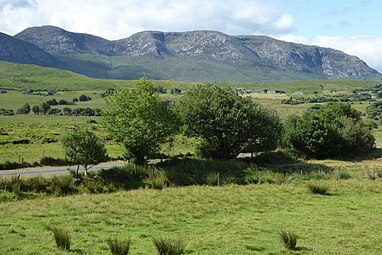
 Mullach Glas viewed from Binn Mhór | |
| Highest point | |
| Elevation | 622 m (2,041 ft)[1] |
| Prominence | 87 m (285 ft)[1] |
| Listing | Hewitt, Arderin, Simm, Vandeleur-Lynam |
| Coordinates | 53°28′57″N 9°36′04″W[1] |
| Naming | |
| English translation | Grey/Green Summit |
| Language of name | Irish |
| Geography | |
 Mullach Glas Location in Ireland | |
| Location | County Galway, Ireland |
| Parent range | Maumturks |
| OSI/OSNI grid | L9374849241 |
| Topo map | OSi Discovery 45 |
| Geology | |
| Type of rock | Pale quartzites, grits, graphitic top bedrock[1] |
Name
Irish academic Paul Tempan records that Irish: Mullach Glas translates as "grey/green summit", and that the peak has also been called "Shannagirah".[2]
Geography
Mullach Glas lies on a small massif in the southeast sector of the Maumturks range, which is separated from the main range by a deep east–west mountain pass called Máméan, a site of pilgrimage dedicated to Saint Patrick since the 5th-century.[4][8][9]
To the north east is the minor subsidiary peak of Mullach Glas NE Top (432 metres (1,417 ft)), also known as Cruiscín (probably meaning "jug").[2][7] To the west is Binn Mhór (661 metres (2,169 ft)), the 3rd-highest peak in the Maumturks range, while to the east is Corcogemore (609 metres (1,998 ft))[3][7][4]
Hill walking
The most straightforward route to the summit Mullach Glas is the 10-kilometre 4–5 hour roundtrip route from the pass at Máméan and back; however, because of its positioning on a high ridge of its own small massif, it can also be climbed as an alternative 10-kilometre 4–5 hour route from Corcogemore in the west, across Mullach Glas, to the summit of Binn Mhór, and then finishing down at Máméan (i.e. the route requires two cars).[7]
Mullach Glas is also climbed as part of the Maamturks Challenge, a 25-kilometre 10–12 hour walk over the full Maumturks range (from Maam Cross to Leenaun), which is considered one of the "great classic ridge-walks of Ireland",[4][10] but of "extreme grade" due to the circa 7,600 feet of total ascent.[7] Since 1975, the University College Galway Mountaineering Club has run the annual "Maamturks Challenge Walk" (MCW),[11] and mans a checkpoint to the west of Mullach Glas in the Máméan pass, and to the east of Mullach Glas on the neighbouring peak of Corcogemore.[12][13]
Gallery
 Mullach Glas (left), and Binn Mhór (centre and right), as viewed from the north
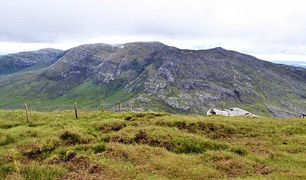 Mullach Glas (back left), and Binn Mhór (centre), viewed from Binn Chaonaigh
 Summit of Mullach Glas, looking west to peak of Binn Mhór


Bibliography
- MountainViews Online Database (Simon Stewart) (2013). A Guide to Ireland's Mountain Summits: The Vandeleur-Lynams & the Arderins. Collins Books. ISBN 978-1-84889-164-7.
- Paul Phelan (2011). Connemara & Mayo - A Walking Guide: Mountain, Coastal & Island Walks. Collins Press. ISBN 978-1848891029.
- Dillion, Paddy (2001). Connemara: Collins Rambler's guide. Harper Collins. ISBN 978-0002201216.
- Dillion, Paddy (1993). The Mountains of Ireland: A Guide to Walking the Summits. Cicerone. ISBN 978-1852841102.
See also
- Twelve Bens, major range in Connemara
- Mweelrea, major range in Killary Harbour
- Lists of mountains in Ireland
- Lists of mountains and hills in the British Isles
- List of Hewitt mountains in England, Wales and Ireland
References
- "Mullach Glas". MountainViews Online Database. Retrieved 9 August 2019.
- Paul Tempan (February 2012). "Irish Hill and Mountain Names" (PDF). MountainViews.ie.
- Mountainviews, (September 2013), "A Guide to Ireland's Mountain Summits: The Vandeleur-Lynams & the Arderins", Collins Books, Cork, ISBN 978-1-84889-164-7
- Dillion, Paddy (1993). The Mountains of Ireland: A Guide to Walking the Summits. Cicerone. ISBN 978-1852841102.
"Walk 49: Corcogemore, Mullach Glas, Binn Mhór, Binn Chaonaigh, Binn idir an Dá Log, Letterbreckaun, Leenaun Hill
- Simon Stewart (October 2018). "Arderins: Irish mountains of 500+m with a prominence of 30m". MountainViews Online Database.
- Simon Stewart (October 2018). "Vandeleur-Lynams: Irish mountains of 600+m with a prominence of 15m". MountainViews Online Database.
- Paul Phelan (2011). Connemara & Mayo - A Walking Guide: Mountain, Coastal & Island Walks. Collins Press. ISBN 978-1848891029.
Route 16: Corkóg
- Éanna Ó Caolla (5 August 2016). "Pilgrims head to Connemara hills for annual walk". Retrieved 2 August 2019.
The site, which is also associated with the pagan Lughnasa Solstice festivals, features a holy well and a Mass Rock (Carraig an Aifrinn) which was used during the repressive penal times when isolated locations were used to host religious ceremonies.
- "Máméan Pilgrimage". National Museum of Ireland.
High up the slopes of the Maum Turk Mountains in Connemara there is a natural passage-way known as Máméan (pass of the birds). At the summit of this rugged track you will find an ancient pilgrim site dedicated to St. Patrick.
- Fairbairn, Helen (2014). Ireland's Best Walks: A Walking Guide. Collins Press. ISBN 978-1848892118. Retrieved 1 August 2019.
Route 36: The Central Maumturks – South
- "The Maumturks Challenge". University College Galway Mountaineering Club (UCGMC). Retrieved 1 August 2019.
- Simon Stewart. "Maumturks Challenge Section 1: Corcog to Mamean". MountainViews Online Database. Retrieved 2 August 2019.
- "Maaumturks Challenge: The Route". University College Galway Mountaineering Club (UCGMC). Retrieved 2 August 2019.
External links
- The Maamturks Challenge, University College Galway Mountaineering Club
- The Maamturks Challenge: Routecard (2015)
- MountainViews: The Irish Mountain Website, Mullach Glas
- MountainViews: Irish Online Mountain Database
- The Database of British and Irish Hills , the largest database of British Isles mountains ("DoBIH")
- Hill Bagging UK & Ireland, the searchable interface for the DoBIH
| British Isles |  | |
|---|---|---|
| Scotland | ||
| Outside Scotland | ||
| England | ||
| Ireland | ||
| County tops |
| |
Mountains and hills of Connacht | |||||||
|---|---|---|---|---|---|---|---|
List of mountains in Ireland | |||||||
| Achill Island |  | ||||||
| Curlew Mountains | |||||||
| Dartry Mountains | |||||||
| Maumturks | |||||||
| Mweelrea Mountains |
| ||||||
| Nephin Range | |||||||
| Ox Mountains | |||||||
| Partry Mountains | |||||||
| Sheeffry Range | |||||||
| Twelve Bens |
| ||||||
| Others | |||||||
Lists of long-distance trails in Ireland | ||||||
|---|---|---|---|---|---|---|
| Long-Distance |
|   | ||||
| Pilgrim path |
| |||||
| Cycle greenway |
| |||||
| Boarded mountain | ||||||
| Fell running | ||||||
Другой контент может иметь иную лицензию. Перед использованием материалов сайта WikiSort.org внимательно изучите правила лицензирования конкретных элементов наполнения сайта.
WikiSort.org - проект по пересортировке и дополнению контента Википедии