geo.wikisort.org - Mountains
The Twelve Bens or Twelve Pins, also called the Benna Beola[2] (Irish: Na Beanna Beola, meaning 'the peaks of Beola'),[lower-alpha 1] is a mountain range of mostly sharp-peaked quartzite summits and ridges in the Connemara National Park[lower-alpha 4] in County Galway, in the west of Ireland.[4] The widest definition of the range includes the Garraun Complex to the north as well as several isolated peaks to the west, and is designated a 16,163-hectare (39,940-acre) Special Area of Conservation.[5]
| Twelve Bens/Benna Beola | |
|---|---|
| Irish: Na Beanna Beola | |
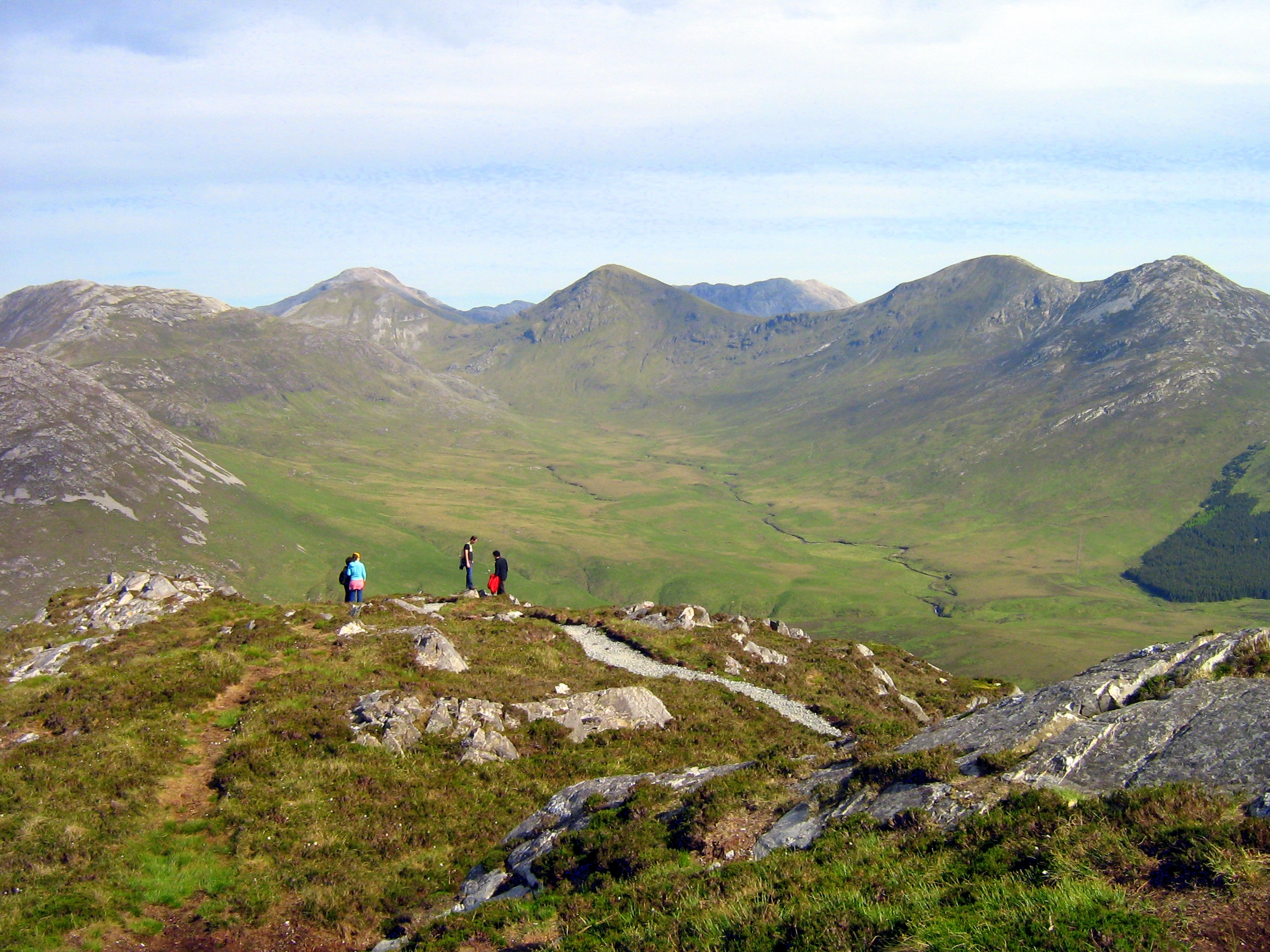
 View of the range from Roundstone village. | |
| Highest point | |
| Peak | Benbaun |
| Elevation | 729 m (2,392 ft)[1] |
| Coordinates | 53.50°N 9.81°W |
| Dimensions | |
| Area | 161.3 km2 (62.3 sq mi) |
| Naming | |
| English translation | The peaks of Beola[lower-alpha 1] |
| Language of name | Irish language |
| Geography | |
 Twelve Bens/Benna Beola Location of the Twelve Bens | |
| Location | Connemara, County Galway, Ireland |
| Provinces of Ireland | Connacht |
| Topo map | OSI Discovery 37, 44 |
| Geology | |
| Age of rock | Precambrian-Cambrian |
| Type of rock | quartzites, grits, graphitic |
| Climbing | |
| Normal route |
|
The highest point is Benbaun at 729 metres (2,392 ft).[6] The range is a popular location for hill-walking activities with the 16–kilometre 8–9 hour Glencoaghan Horseshoe (Gleann Chóchan), considered one of the best ridge-walks in Ireland.[7][6] Topographically, the range is partnered with the Maumturks range to the east of the Inagh valley (a Western Way route);[6] and both share a common geology being largely composed of metamorphic marine rocks, being predominantly resistant quartzite but with deposits of schists in the valleys (known as Connemara Dalradian rocks).[8]
Naming
"Ben" an anglicized translation of the Irish language word "Binn", meaning "peak".[3] According to Irish academic Paul Tempan,[lower-alpha 5] "An odd thing about the Twelve Bens of Connemara is that nobody seems to know exactly which are the twelve peaks in question", and noting that there are almost 20 peaks with "Ben" or "Binn" in their name.[3][9] Tempan notes that term "twelve peaks" can be at least dated to the Irish historian Ruaidhrí Ó Flaithbheartaigh, whose writings in 1684 said: "On the north-west of Ballynahinsy [Ballynahinch], are the twelve high mountaines of Bennabeola, called by marriners the twelve stakes [stacks], being the first land they discover as they come from the maine [sea]", but he did not list them.[3]
The most common list of the twelve peaks in question are the peaks with an elevation above 500 metres in the core range, and that are not considered subsidiary peaks (e.g. they have a non-trivial prominence, and have been traditionally noted as peaks on historic maps, per § List of peaks below).[6]
Tempan notes the issue of "twelve" does not arise in the Irish language name as they are simply labelled "Na Beanna Beola", which translates as "the peaks of Beola".[3] Beola was a leader of the Fir Bolg, and a giant; his name appears in the Connemara village Toombeola, or Irish language "Tuaim Beola".[3]
Geography

The Twelve Bens range is a core massif of 22 peaks above 100 metres (330 ft) in elevation, centred around the highest peak in the range, Benbaun 729 metres (2,392 ft). To the north of this core massif lies the separate subsidiary massif of the Garraun Complex with 9 peaks around Garraun 598 metres (1,962 ft). To the west of the core massif lies 7 other isolated or subsidiary "outlier" peaks, thus giving a total of 38 Bens with an elevation above 100 metres.[6][7]
While the Bens are not as high as those of the ranges in Kerry (e.g. MacGillycuddy's Reeks and the Mountains of the Dingle Peninsula), their rocky peaks and ridges contrast with the surrounding sea-level landscape (unlike Kerry, there are no mountain-passes in Connemara), and give the range an imposing feel.[6][7]
The range is bounded by the Inagh Valley and the R344 road to the east, while the N59 road (or, the "Clifden Road"), circles and bounds the core massif (and most of the outliers), from the southerly, westerly and northerly directions. The Garraun Complex lies to the north of the N59 road at Kylemore Lough.[6][7]
Core massif
The 22 peaks in the core massif of the Twelve Bens range naturally split into three sections:[11]
- Southern Bens, 12 southern Bens form a horseshoe around the Glencoaghan Valley, and include the 7 major Bens of: Derryclare, Bencorr, Bencollaghduff, Benbreen, Bengower, Benlettery, and Benglenisky; and 5 subsidiary Bens of: Bencorr North Top, Benbreen Central Top, Benbreen North Top, Binn an tSaighdiúra, and Bencorrbeg; and
- Central Bens, 7 central Bens that sit along a large east-west ridge with Benbaun at its centre, and include the 4 major Bens of Benbaun, Benfree, Muckanaght, and Bencullagh; and the 3 subsidiary Bens of Knockpasheemore, Maumonght, and Maumonght SW Top; and
- Northern Bens, 3 northern Bens that lies on the small massif of the major Ben of Benbrack, and include the 2 subsidiary Bens of Knockbrack and another smaller peak called, Benbaun; just beside the Northern Bens lies the outlier Ben of Diamond Hill.
The core massif is also known for its deep glaciated U-shaped valleys, around which groups of Bens lie in a "horseshoe formation":[11]
- Glencoaghan: most southerly valley from which the Glencoaghan river flows; the Glencoaghan Horseshoe is a major hill-walking route in Ireland;[12][7][6]
- Owenglin: western valley from which the Owenglin river flows; the Owenglin Horseshoe is also a noted hill-walking route;[13]
- Gleninagh: eastern valley from which the Gleninagh river flows; contains Carrot Ridge, an important area for rock-climbing;[14]
- Polladirk: north-westerly valley from which the Polladirk river flows; a popular scenic view from Diamond Hill is into this valley;
- Glencorbet: north-easterly valley from which the Kylemore river flows; the Glencorbet Horseshoe is a popular route in the Bens.[15][16]
Geology

The core massif of the Twelve Bens range are largely composed of metamorphic marine rocks, being predominantly resistant quartzite but with deposits of schists in the valleys (known as Connemara Dalradian rocks).[8][5][17]
These rocks derive from sediments that were deposited in a warm shelf sea some 700 to 550 million years ago (e.g. Precambrian-Cambrian).[17] Movements in the earth's crust, and the closure of the Iapetus Ocean, transformed these sediments into crystalline schists that lie underneath the base of the mountain range, which local erosion and uplift then brought to the surface.[8][17] The summits of the core massif (and some outliers) are made of weather-resistant quartzite, while the sides of the peaks are composed of schists and grey marbles.[17]
In contrast, the mountains to the north of the core Twelve Bens massif, the Garraun Complex, have a different type of geology, that is composed of gneiss and different forms of sandstones and mudstones.[5]
Scattered throughout the range are parts of gabbro (Doughruagh and Currywongaun), mica schist (Muckanaght), and outcrops of marble (south of Kylemore Lough).[5]
The final Ice Age, circa 10,000 years ago, also sculpted the landscape leaving behind deposits of sand and gravel; there are widespread boulder-clay and erratic boulders across the range.[17]
Special Area of Conservation (SAC)

The entire Twelve Bens range (including the Garraun Complex) is a Special Area of Conservation (SAC) (Site Code:002031), as selected for a range of habitats and species listed under the Annex I / II of the E.U. Habitats Directive.[5] The items of note on the SAC habitats list includes: Oligotrophic Waters, Alpine Heaths, Active Blanket Bogs, remnants of Oak Woodland, Rhynchosporion Vegetation, and Siliceous Scree and Rocky Slopes; while the species list includes: Freshwater Pearl Mussel, Atlantic Salmon, Otter, and Slender Naiad.[5] In addition, the 16,163-hectare site includes a some of the rarer Red Data Book species of plant.[5] The SAC directive on the range describes it as "One of the largest and most varied sites of conservation interest in Ireland".[5]
Climbing
The range is popular with hill walkers, fell runners, and rock climbers,[18]
Hill walking
The Irish Times outdoors correspondent, John G. Dwyer, said of the Twelve Bens, "These are true kickass mountains, with criminally stunning views [..]".[19]
The 16-kilometre (9.9 mi) 8–9 hour Glencoaghan Horseshoe (Irish: Gleann Chóchan)[lower-alpha 2] is noted as providing some of the "most exhilarating mountaineering in Ireland",[23] and is called "a true classic" by guidebook authors.[7][6][12] Other similar distanced "horseshoe" loop walks are the 19–kilometre 10–12 hour Owenglin Horseshoe,[13] the 15–kilometre 8–9 hour Gleninagh Horseshoe,[14] and the 14–kilometre 6–7 hour Glencorbet Horseshoe.[16][15]
An even more serious undertaking is the 28-kilometre (17 mi) Twelve Bens Challenge, climbing all 12 Bens in a single 24-hour day.[lower-alpha 3]
Rock climbing

The Twelve Bens have a number of rock climbing locations, the most notable of which is in the Gleann Eighneach valley at the eastern spur of Benncorr (from Binn an tSaighdiúra to Bencorrbeg; also called "Carrot Ridge" Irish: Meacan Buí). The climbs vary from Diff (D) to Very Severe (VS) and range from 150 metres to 320 metres in length, with notable routes being Carrot Ridge (275m D), and Seventh Heaven (330m HS).[18]
In addition, the large easterly corrie between the summits of Derryclare and the summit of Bencorr, known as Irish: Log an Choire Mhóir (meaning "wood of the big corrie"), also contains several large 200 metre multi-pitch graded rock climbs at grades of Diff (D) to Very Diff (VD), the most notable of which is The Knave (VD, 225 m); and the smaller corrie between the summit of Bencorr and the summit of Bencorr North Top, known as Irish: Log an Choire Bhig (meaning "wood of the small corrie"), has a number of shorter but harder climbs including Corner Climb (VS 4c, 30 m).[25]
List of peaks
The following is a download from the MountainViews Online Database, who list 38 identifiable peaks in the wider Twelve Bens range (i.e. core massif, Garraun complex, and various outliers to the west), with an elevation, or height, above 100 metres (328 ft)
The list below highlights the 12 Bens most associated with being the Twelve Bens from Ó Flaithbheartaigh's original record.[6] Of the standalone "Bens" (e.g. not listed as a "Top" of a parent Ben) that are over 500 metres (1,640 ft) in height but are not listed in this 12, Binn an tSaighdiúra has a prominence of only 8 metres and would not qualify as an independent mountain on any recognised scale (the lowest prominence is 15 metres for the Vandeleur-Lynam classification); Maumonght does have a prominence exceeding 50 metres, and even has a subsidiary peak (Maumonght SW Top), however, Maumonght rarely appears on historic maps of the range and is not considered a "Ben";[3] Bencorrbeag also has a non-trivial prominence of 42 metres, however, it is considered unlikely given its positioning that it could have been distinguished by mariners from the sea (Ó Flaithbheartaigh's original premise).[6][3]
| Height Rank |
Prom. Rank |
Name | Irish Name (if different) | Translation | Area | Height (m) |
Prom. (m) |
Height (ft) |
Prom. (ft) |
Topo Map |
OSI Grid Reference |
|---|---|---|---|---|---|---|---|---|---|---|---|
| 1 | 1 | Benbaun | Binn Bhán | White Peak[lower-alpha 6] | 12 Bens - Core | 729 | 684 | 2,392 | 2,244 | 37 | L786539 |
| 2 | 4 | Bencorr | Binn Chorr[lower-alpha 7] | Pointed Peak | 12 Bens - Core | 711 | 306 | 2,333 | 1,004 | 37 | L812522 |
| 3 | 10 | Bencollaghduff | Binn Dubh | Black Peak/Peak of Black Hags[lower-alpha 8] | 12 Bens - Core | 696 | 191 | 2,283 | 627 | 37 | L798530 |
| 4 | 11 | Benbreen | Binn Braoin | Braon's Peak[lower-alpha 9] | 12 Bens - Core | 691 | 186 | 2,267 | 610 | 37 | L783515 |
| 5 | 38 | Bencorr North Top | — | — | 12 Bens - Core | 690 | 5 | 2,264 | 16 | 37 | L809524 |
| 6 | 31 | Benbreen Central Top | — | — | 12 Bens - Core | 680 | 25 | 2,231 | 82 | 37 | L781520 |
| 7 | 16 | Derryclare | Binn Doire Chláir[lower-alpha 10] | Peak of Derryclare | 12 Bens - Core | 677 | 129 | 2,221 | 423 | 37 | L815510 |
| 8 | 35 | Benbreen North Top | — | — | 12 Bens - Core | 674 | 16 | 2,211 | 52 | 37 | L784522 |
| 9 | 9 | Bengower[lower-alpha 11] | Binn Gabhar | Goats' Peak | 12 Bens - Core | 664 | 196 | 2,178 | 643 | 37 | L783507 |
| 10 | 12 | Muckanaght | Muiceanach | Hill like a Pig | 12 Bens - Core | 654 | 179 | 2,146 | 587 | 37 | L767541 |
| 11 | 37 | Binn an tSaighdiúra | — | Peak of the Soldier[lower-alpha 12] | 12 Bens - Core | 653 | 8 | 2,142 | 26 | 37 | L811528 |
| 12 | 24 | Benfree | Binn Fraoigh | Peak of the Heather[lower-alpha 13] | 12 Bens - Core | 638 | 48 | 2,093 | 157 | 37 | L778544 |
| 13 | 14 | Bencullagh | An Chailleach | [Peak of] The Hag/Witch[lower-alpha 14] | 12 Bens - Core | 632 | 154 | 2,073 | 505 | 37 | L756537 |
| 14 | 23 | Maumonght[lower-alpha 15] | Mám Uchta | Pass of the Breast/Ridge | 12 Bens - Core | 602 | 54 | 1,975 | 177 | 37 | L749539 |
| 15 | 2 | Garraun[lower-alpha 16] | Maolchnoc | Bald Hill | Garraun Complex | 598 | 553 | 1,962 | 1,814 | 37 | L767610 |
| 16 | 36 | Benchoona East Top | — | — | Garraun Complex | 585 | 15 | 1,919 | 49 | 37 | L766616 |
| 17 | 7 | Benbrack | Binn Bhreac | Speckled Peak[lower-alpha 17] | 12 Bens - Core | 582 | 264 | 1,909 | 866 | 37 | L766558 |
| 18 | 28 | Benchoona | Binn Chuanna | Peak of Cuanna[lower-alpha 18] | Garraun Complex | 581 | 36 | 1,906 | 118 | 37 | L763617 |
| 19 | 21 | Benlettery | Binn Leitrí | Peak of the Wet Hillsides[lower-alpha 19] | 12 Bens - Core | 577 | 62 | 1,893 | 203 | 44 | L775495 |
| 20 | 26 | Bencorrbeg | Binn an Choire Bhig | Peak of the Little Corrie | 12 Bens - Core | 577 | 42 | 1,893 | 138 | 37 | L816533 |
| 21 | 29 | Garraun South Top | — | — | Garraun Complex | 556 | 31 | 1,824 | 102 | 37 | L763606 |
| 22 | 32 | Garraun South-West Top | — | — | Garraun Complex | 549 | 21 | 1,801 | 69 | 37 | L755607 |
| 23 | 8 | Doughruagh | Dúchruach | Black Stack | Garraun Complex | 526 | 211 | 1,726 | 692 | 37 | L751594 |
| 24 | 33 | Doughruagh South Top | — | — | Garraun Complex | 525 | 17 | 1,722 | 56 | 37 | L751592 |
| 25 | 25 | Benglenisky | Binn Ghleann Uisce | Peak of the Glen of Water | 12 Bens - Core | 516 | 48 | 1,693 | 157 | 37 | L766501 |
| 26 | 27 | Benbaun (477 m) | Binn Bhán/Maolán | White Peak | 12 Bens - Core | 477 | 42 | 1,565 | 138 | 37 | L765568 |
| 27 | 30 | Maumonght SW Top | Binn Bhreac | Speckled Peak | 12 Bens - Core | 454 | 29 | 1,490 | 95 | 37 | L744534 |
| 28 | 5 | Diamond Hill | Binn Ghuaire | Guaire's Peak[lower-alpha 20] | 12 Bens - Outlier | 442 | 277 | 1,450 | 909 | 37 | L732571 |
| 29 | 22 | Knockbrack | Cnoc Breac | Speckled Hill | 12 Bens - Core | 442 | 55 | 1,450 | 180 | 37 | L749565 |
| 30 | 34 | Knockpasheemore | Binn Charrach | Rocky Peak | 12 Bens - Core | 412 | 17 | 1,352 | 56 | 37 | L807557 |
| 31 | 3 | Tully Mountain | — | — | 12 Bens - Outlier | 356 | 331 | 1,168 | 1,086 | 37 | L673611 |
| 32 | 6 | Letterettrin[lower-alpha 21] | Binn Mhór | Big Peak | Garraun Complex | 333 | 268 | 1,093 | 879 | 37 | L796620 |
| 33 | 15 | Cregg | — | — | 12 Bens - Outlier | 297 | 142 | 974 | 466 | 37 | L715524 |
| 34 | 20 | Currywongaun | Corr Uí Mhongáin | Uí Mhongáin's Hill | Garraun Complex | 273 | 109 | 896 | 358 | 37 | L731596 |
| 35 | 18 | Townaloughra East Top | — | — | 12 Bens - Outlier | 216 | 112 | 709 | 367 | 37 | L688541 |
| 36 | 19 | Gortrumnagh | (unknown) | (unknown) | 12 Bens - Outlier | 174 | 110 | 571 | 361 | 37 | L628516 |
| 37 | 13 | Maumfin | Mám Fionn | White Pass | 12 Bens - Outlier | 172 | 157 | 564 | 515 | 37 | L647588 |
| 38 | 17 | Knockaunbaun | An Cnocán Bán | White Hillock | 12 Bens - Outlier | 146 | 128 | 479 | 420 | 37 | L605596 |
See also
- Mweelrea, major range in Killary Harbour
- Maumturks, major range in Connemara
- List of Irish counties by highest point
- Lists of mountains in Ireland
- Lists of mountains and hills in the British Isles
Notes
- The translation is "the peaks of Beola" who was believed to be a giant and chieftain of the Fir Bolg, whose name features in the village Tuaim Beola (Toombeola).[3]
- Also known as the "Derryclare Horseshoe" as it is normally started from the Derryclare end (e.g. counterclockwise), is a 14 to 16 kilometres (8.7 to 9.9 mi) "horseshoe"-shaped circuit (the final length depending on whether the "loop" is completed by walking back to the base of "Derryclare"), that takes in six of the twelve bens, almost 5,000 ft (1,500 m) of elevation, and takes circa 6 to 9 hours to complete depending on ability and fitness.[20][21][22]
- The "12 Bens Challenge" was organised by the Beanna Beola Hillwalking Club on a yearly basis since 2006; it is for advanced hill-walkers only, and covers 28 kilometres (17 mi), 8,300 ft (2,500 m) of elevation, and takes circa 12–14 hours to complete.[24]
- Only part of the range is inside the boundary of the Connemara National Park; the rest is on private property, but climbing access is granted.
- Paul Tempan was a research fellow in the Department of Irish and Celtic Studies at Queen's University Belfast,[9] and who was part of the Northern Ireland place names project,;[10] in 2010, Tempan wrote the Irish Hill and Mountain Names, collating the accepted names (e.g from academic research, the Placenames Database of Ireland (loganim.ie), and the Ordnance Survey Ireland) for Irish mountains from the MountainViews database, and which he updated in 2012.[3]
- The name is assumed to derive from the abundance of white quartzite rock on its summit[3]
- Cartographer and climbing author Tim Robinson gave an alternative name of Irish: Binn an Choire Mhóir meaning "peak of the big corrie". The British sappers set up a beacon on this peak during the first Ordnance Survey in Ireland.[3]
- The "black hags" are not referring to witches, but to cormorant birds.[3]
- Braon in the Irish language can mean "drip" or "drop", but is more likely related to the Irish personal name, and it is the basis of the surnames Ó Braoin and Mac Braoin, anglicised as Breen and McBreen in the area.[3]
- The Irish language term "clár", can mean both a "plain" and a "board"/"plank-bridge". Thus Derryclare, from "Doire Chláir", could mean 'oak-wood of the plain' or 'oak-wood of the plank-bridge'. The name seems to have been transferred by the Ordnance Survey from the townland of Derryclare situated to the east to the mountain itself.[3]
- Mistakenly marked as "Glengower" on the Discovery series OS map.[3]
- It is said that a British sapper from the first Ordnance Survey in Ireland fell to his death here during survey work on the first 6-map series in the 1830s.[3]
- On the Discovery OS map this peak is marked as "Luggatarriff", meaning "hollow of the bull", which Paul Tempan notes probably applies to a hollow on the slopes of Benfree.[3]
- A woman known as "Cailleach an Chlocháin", meaning "the witch of Clifden", was a famous character in the 19th-century.[3]
- Despite is non-trivial prominence, Maumonght is unnamed on many maps, including Tim Robinson's map, however, a lower peak to the SW at 454 metres, is named Binn Bhreac (properly Maumonght SW Top). This may explain why Maumonght rarely appears in any list of the actual 12 Bens. "Maumonght" is also odd as an anglicised form, as Paul Tempan notes that it does not suggest any Irish version, and wonders if it was a typo for "Maumought".[3]
- Paul Tempan notes that Garraun is clearly also a name of Irish origin, and may either be from the Irish name "garrán" (meaning grove), or, more likely, from the Irish name "géarán" (meaning "fang"). While the summit of Garraun is flattish, the eastern ridge leading to it is sharp enough to have deserved the name of "fang". Tempan notes that the name "Maolchnoc" could be the true Irish name for the rounded summit, while "An Géarán" would denote the sharp ridge descending to Lough Fee.[3]
- The summit of this mountain is strewn with lumps of white quartz.[3]
- Cuanna is probably a personal name. A townland nearby is named Tooreenacoona ("Tuairín Uí Chuanna", meaning "O'Cooney's Green").[3]
- The townland of Lettery (Irish: Leitrí, "wet hillsides") is on the southerly slopes of the peak. Another name Bindowglass or Bendouglas (Irish: Binn Dúghlais, "peak of the black stream") is recorded as early as 1684 by Ruaidhrí Ó Flaithbheartaigh; both names referring to the wet state of the peak. Ó Flaithbheartaigh mentions a pool of water on the summit which turns the hair white of anyone who washes in it.[3]
- Guaire Aidne was a king of Connacht, and Bengooria is an anglicised form of Binn Ghuaire.[3]
- This hill is in the townland of Letterettrin / Irish: Leitir Eitreann, meaning "hillside of furrows".[3]
References
- "Benbaun". MountainViews Online Database. Retrieved 8 February 2019.
- "The Twelve Pins or Benna Beola" (English), Beanna Beola (Irish). Placenames Database of Ireland.
- Tempan, Paul (February 2012). "Irish Hill and Mountain Names" (PDF). MountainViews.ie. pp. 17–18.
- "Twelve Bens". Encyclopædia Britannica. Retrieved 6 March 2020.
- "Site Name: The Twelve Bens/Garraun Complex SAC" (PDF). Department of Culture, Heritage and the Gaeltacht. 2017. Retrieved 29 July 2019.
Site Code: 002031
- Dillion, Paddy (2001). Connemara: Collins Rambler's guide. Harper Collins. ISBN 978-0002201216.
Walk 30: Gleann Chóchan Horseshoe
- Helen Fairbairn (30 December 2014). Ireland's Best Walks: A Walking Guide (Walking Guides). Collins Press. ISBN 978-1848892118.
ROUTE 34: The Glencoaghan Horseshoe. A true classic
- Ronán Hennessy (29 August 2012). "Connemara before Clifden: The Geology of Connemara". University College Cork. Retrieved 29 July 2019.
- Paul Tempan (2006). "Two Mountain Names: Slieve Felim and Mauherslieve" (PDF). North Munster Antiquarian Journal. 6: 121.
The formula is preserved in the range known in English as "The Twelve Bens of Connemara", although the names of the exact twelve peaks are no longer known
- "About Us". Placenamesni.org. Retrieved 13 March 2020.
- Lynam, Joss; Robinson, Tim (1988). Mountains of Connemara: Hill Walker's Guide. Folding Landscape. ISBN 978-0950400242.
- Paul Phelan (2011). Connemara & Mayo - A Walking Guide: Mountain, Coastal & Island Walks. Collins Press. ISBN 978-1848891029.
Route 12: Glencoaghan Horseshoe. one of Ireland's most dramatic walks
- Dillion, Paddy (2001). Connemara: Collins Rambler's guide. Harper Collins. ISBN 978-0002201216.
Walk 24: Owenglin Horseshoe
- Dillion, Paddy (2001). Connemara: Collins Rambler's guide. Harper Collins. ISBN 978-0002201216.
Walk 28: Gleann Eidhneach Horseshoe
- Paul Phelan (2011). Connemara & Mayo - A Walking Guide: Mountain, Coastal & Island Walks. Collins Press. ISBN 978-1848891029.
Route 11: Glencorbet Horseshoe
- Helen Fairbairn (30 December 2014). Ireland's Best Walks: A Walking Guide (Walking Guides). Collins Press. ISBN 978-1848892118.
ROUTE 33: The Glencorbet Horseshoe. A true classic
- "Connemara National Park: Geology". Connemara National Park. 2017. Retrieved 29 July 2019.
- "Glenn Eighneach". Irish Climbing Wiki.
The finest rock formations in the Twelve Bens are found in the south wall of Gleann Eidheanach (Glen Inagh), running from Binn an Choire Bhig to Mám na bFhonsaí, east of Binn Dubh (L808530).
- John G. Dwyer (29 October 2015). "A walk for the weekend: Twelve Bens, Connemara, Co Galway". Irish Times. Retrieved 8 March 2020.
- Liam Johnson (12 September 2015). "Glencoaghan Horseshoe: Viewranger Statistics". theramblers.ie.
- "Glencoaghan Horseshoe (anticlockwise)". viewranger maps. 2013.
- "More Challenging Climbing: The Glencoaghan Horseshoe". Walk Conemara.
- Tom Doherty (22 June 2016). "A walk for the weekend: The Twelve Bens of Connemara are a hard walk but worth it". Irish Times.
Even if you had to crawl across bogs to get to them, it would be worth it as the nine [should be six] peaks which form the Glencoaghan Horseshoe provide some of the most exhilarating mountaineering on this island.
- "12 Bens Challenge". Na Beanna Beola Hill Walking Club. 2018.
The route begins at the Inagh Valley Inn and ends at the Bard’s Den in Letterfrack. The total distance covered is approximately 28km and the total height gain for the route is approximately 2530m (8300ft). On average it takes 12–14 hours to complete and should only be attempted by competent hill-walkers.
- "Inagh Valley: Log an Choire Mhóir, Log and Choire Bhig". Irish Online Climbing Wiki. Retrieved 1 August 2019.
Further reading

- Lynam, Joss; Robinson, Tim (1988). Mountains of Connemara: Hill Walker's Guide. Folding Landscape. ISBN 978-0950400242.
- Dillion, Paddy (1993). The Mountains of Ireland: A Guide to Walking the Summits. Cicerone. ISBN 978-1852841102.
- Dillion, Paddy (2001). Connemara: Collins Rambler's guide. Harper Collins. ISBN 978-0002201216.
- Paul Phelan (2011). Connemara & Mayo - A Walking Guide: Mountain, Coastal & Island Walks. Collins Press. ISBN 978-1848891029.
- Fairbairn, Helen (2014). Ireland's Best Walks: A Walking Guide. Collins Press. ISBN 978-1848892118.
- Connemara (Superwalker) Map (Waterproof Folded Map) (1:30,000 scale). Harvey Maps. 2015. ISBN 978-1851373383.
External links
- Mountainview: The Twelve Bens Range
- The Twelve Bens Challenge: Routecard (2015)
- Irish Rock Climbing Database: Gleann Eighneach
- Irish Rock Climbing Database: Inagh Valley (Benorr & Derryclare)
| British Isles |  | |
|---|---|---|
| Scotland | ||
| Outside Scotland | ||
| England | ||
| Ireland | ||
| County tops | ||
Mountains and hills of Connacht | |||||||
|---|---|---|---|---|---|---|---|
List of mountains in Ireland | |||||||
| Achill Island |  | ||||||
| Curlew Mountains | |||||||
| Dartry Mountains | |||||||
| Maumturks | |||||||
| Mweelrea Mountains |
| ||||||
| Nephin Range | |||||||
| Ox Mountains | |||||||
| Partry Mountains | |||||||
| Sheeffry Range | |||||||
| Twelve Bens |
| ||||||
| Others | |||||||
Authority control | |
|---|---|
| General |
|
| National libraries | |
На других языках
[de] Twelve Bens
Die Twelve Bens oder Twelve Pins (irisch Na Beanna Beola) sind ein malerischer Gebirgszug in Connemara im Westen Irlands. Von der Spitze der maximal 730 Meter hohen Berge bietet sich spektakuläre Blicke über das umliegende Land. Besucher schätzen vor allem die Einsamkeit jenseits der Touristenzentren Irlands. Der Gebirgszug aus scharfkantige verwitternden Quarzitgesteinen ist mit dem Maumturkgebirge auf der anderen Seite des Glen Inagh (irisch Gleann Eidhneach) verbunden.- [en] Twelve Bens
[es] Twelve Bens
Twelve Bens o Twelve Pins (irlandés Na Beanna Beola) es una pequeña cordillera de sierras de cuarcita de picos muy agudos, ubicado en el noreste de Roundstone en Connemara en el oeste de la República de Irlanda. Los corredores en montaña pueden recorrer los doce picos en un solo día. Topográficamente, esta cordillera está emparentada con la cordillera Maumturks al otro lado del solitario Glen Inagh (y la ruta de Sendero Occidental, un sendero de largo recorrido). La frecuente pluviosidad y las montañas muy escarpadas producen una abundancia de pequeños arroyos y corrientes que descienden hasta los valles de fondo ancho que quedan debajo de los Twelve Pins para unirse a cursos de agua más grandes. Los Twelve Pins no son excepcionalmente altos, con su pico más alto de aproximadamente 730 metros. Proporcionan excelentes oportunidades para caminar y trepar para los entusiastas de las actividades al aire libre.[fr] Twelve Bens
Les Twelve Bens ou Twelve Pins (en irlandais Na Beanna Beola) sont un ensemble de monts dans le Connemara.[it] Twelve Bens
I Twelve Bens o Twelve Pins (gaelico irlandese: Na Beana Beola, "le dodici cime") sono un complesso montagnoso di dodici celebri e pittoresche cime situate nel Connemara, in Irlanda. La loro altezza è poco più che collinare (massimo 730 metri), ma nel territorio dove sono situate svettano accanto alle vicine Maumturks, concedendo agli appassionati di trekking splendide vedute con non eccessiva fatica: a volte addirittura i più esperti riescono nell'impresa di tutte e dodici le vette in un giorno.Другой контент может иметь иную лицензию. Перед использованием материалов сайта WikiSort.org внимательно изучите правила лицензирования конкретных элементов наполнения сайта.
WikiSort.org - проект по пересортировке и дополнению контента Википедии