geo.wikisort.org - Mountains
This is a list of Furth mountains in Britain and Ireland by height. Furths are defined as mountains that meet the classification criteria to be a Scottish Munro, including being over 3,000 feet (914.4 m) in elevation, but which are furth of (i.e. "outside" of) Scotland.[1][2][3] They are also called Welsh Munros, Irish Munros,[4] and English Munros respectively, or the three-thousanders,[lower-alpha 2] as in The Welsh 3000 challenge.
| Furth | |
|---|---|
 Caher, MacGillycuddy's Reeks, Ireland, is the only Furth to have a prominence below 30 m (98 ft)[lower-alpha 1] | |
| Highest point | |
| Elevation | over 3,000 ft (914 m) |
| Prominence | no requirement[lower-alpha 1] |
| Geography | |
| Location |
|
Some Furth definitions add a topographical prominence above 30 metres (98 feet), akin to a Scottish Murdo, however the official Scottish Mountaineering Club ("SMC") lists includes Furths with a prominence below this level.[lower-alpha 1][5] Applying the Real Munro definition to a Furth, requires a prominence above 150 metres (492 feet), akin to a Marilyn, and these 14 Furths are marked with (‡) in the tables below.[6]
The SMC lists 34 Furths: six in England, 15 in Wales, and 13 in Ireland.[7] These compare with 282 Munros and 227 Munro Tops in Scotland.[8] 33 have the 30 metres (98 feet) in prominence to be Murdos. 14 have the 150 metres (492 feet) of prominence to be Real Munros: four in England, six in Wales, and five in Ireland. 10 have the 600 metres (1,969 feet) in prominence to be P600s, which being over 3,000 ft, makes them "Super-Majors": three in England, three in Wales, and four in Ireland.
Climbers who complete all Munros, and the SMC list of 34 Furths, are called Furthists; the SMC keeps a register which numbered 631 Furthists at October 2018.[9] The first Furthist is registered as James A. Parker who completed all 34 Furths on the 19 April 1929 (having become a Munroist in 1927).[10] In 1986 Ashley Cooper became the first person to climb all the 3,000 ft summits in one continuous expedition, of 111 days, 2,500 km, and 150 km of ascent.[10][11]
Furth mountains by height
This list was downloaded from the Database of British and Irish Hills ("DoBIH") in October 2018, and are peaks the DoBIH marks as being Furths ("F").[lower-alpha 3][14] The SMC updates their list of official Furths from time to time, and the DoBIH also updates their measurements as more detailed surveys are recorded, so these tables should not be amended or updated unless the entire DoBIH data is re-downloaded again.
| Height Rank | Name [other] | Country | Section / Region | County | Height (m) | Prom. (m) | Height (ft) | Prom. (ft) | Topo Map | OS Grid Reference | Classification (§ DoBIH codes) |
|---|---|---|---|---|---|---|---|---|---|---|---|
| 1 | Snowdon [Yr Wyddfa] | Wales | 30B: Snowdonia | Gwynedd | 1,085 | 1,039 | 3,560 | 3,409 | 115 | SH609543 | Ma,F,Sim,Hew,N,CoH,CoU,CoA |
| 2 | Crib y Ddysgl | Wales | 30B: Snowdonia | Gwynedd | 1,065 | 72 | 3,495 | 236 | 115 | SH610551 | F,Sim,Hew,N |
| 3 | Carnedd Llewelyn | Wales | 30B: Snowdonia | Conwy/Gwynedd | 1,064 | 750 | 3,491 | 2,461 | 115 | SH683643 | Ma,F,Sim,Hew,N,CoU |
| 4 | Carnedd Dafydd | Wales | 30B: Snowdonia | Conwy/Gwynedd | 1,044 | 111 | 3,425 | 364 | 115 | SH662630 | Hu,F,Sim,Hew,N |
| 5 | Carrauntoohil [Corrán Tuathail] | Ireland | 50C: MacGillycuddy's Reeks | Kerry | 1,039 | 1,039 | 3,407 | 3,407 | 78 | V803844 | Ma,F,Sim,Hew,Dil,A,VL,CoH,CoU |
| 6 | Beenkeragh | Ireland | 50C: MacGillycuddy's Reeks | Kerry | 1,008 | 91 | 3,308 | 298 | 78 | V801852 | F,Sim,Hew,Dil,A,VL,sHu |
| 7 | Glyder Fawr | Wales | 30B: Snowdonia | Conwy/Gwynedd | 1,001 | 642 | 3,284 | 2,106 | 115 | SH642579 | Ma,F,Sim,Hew,N |
| 8 | Caher | Ireland | 50C: MacGillycuddy's Reeks | Kerry | 1,000 | 100 | 3,281 | 327 | 78 | V792838 | F,Sim,Hew,Dil,A,VL,sHu |
| 9 | Glyder Fach | Wales | 30B: Snowdonia | Conwy | 994 | 75 | 3,262 | 244 | 115 | SH656582 | F,Sim,Hew,N |
| 10 | Cnoc na Peiste [Knocknapeasta] | Ireland | 50C: MacGillycuddy's Reeks | Kerry | 988 | 254 | 3,241 | 833 | 78 | V835841 | Ma,F,Sim,Hew,Dil,A,VL |
| 11 | Scafell Pike | England | 34B: Lake District C&W | Cumbria | 978 | 912 | 3,209 | 2,992 | 89 90 | NY215072 | Ma,F,Sim,Hew,N,W, B,Sy,Fel,CoH,CoU,CoA |
| 12 | Pen yr Ole Wen | Wales | 30B: Snowdonia | Conwy/Gwynedd | 978 | 45 | 3,209 | 148 | 115 | SH655619 | F,Sim,Hew,N |
| 13 | Foel Grach | Wales | 30B: Snowdonia | Conwy/Gwynedd | 975 | 42 | 3,200 | 137 | 115 | SH688659 | F,Sim,Hew,N |
| 14 | Caher West Top | Ireland | 50C: MacGillycuddy's Reeks | Kerry | 973 | 24 | 3,194 | 79 | 78 | V789840 | F,Dil,VL,sSim |
| 15 | Maolan Bui | Ireland | 50C: MacGillycuddy's Reeks | Kerry | 973 | 41 | 3,192 | 135 | 78 | V832838 | F,Sim,Hew,Dil,A,VL |
| 16 | Scafell | England | 34B: Lake District C&W | Cumbria | 964 | 132 | 3,162 | 434 | 89 90 | NY206064 | Hu,F,Sim,Hew,N,W,B,Sy,Fel |
| 17 | Yr Elen | Wales | 30B: Snowdonia | Gwynedd | 962 | 57 | 3,156 | 187 | 115 | SH673651 | F,Sim,Hew,N |
| 18 | Cnoc an Chuillinn | Ireland | 50C: MacGillycuddy's Reeks | Kerry | 958 | 54 | 3,143 | 177 | 78 | V823833 | F,Sim,Hew,Dil,A,VL |
| 19 | Na Cnamha | Ireland | 50C: MacGillycuddy's Reeks | Kerry | 957 | 37 | 3,138 | 122 | 78 | V800846 | F,Sim,Hew,A,VL |
| 20 | Brandon Mountain | Ireland | 49A: Dingle Peninsula | Kerry | 952 | 927 | 3,122 | 3,041 | 70 | Q460116 | Ma,F,Sim,Hew,Dil,A,VL |
| 21 | Helvellyn | England | 34C: Lake District E | Cumbria | 950 | 712 | 3,117 | 2,336 | 90 | NY342151 | Ma,F,Sim,Hew,N,W,B,Sy,Fel,CoH |
| 22 | Y Garn | Wales | 30B: Snowdonia | Gwynedd | 947 | 236 | 3,107 | 774 | 115 | SH630595 | Ma,F,Sim,Hew,N |
| 23 | Foel-fras | Wales | 30B: Snowdonia | Conwy/Gwynedd | 944 | 63 | 3,097 | 206 | 115 | SH696681 | F,Sim,Hew,N |
| 24 | The Big Gun | Ireland | 50C:MacGillycuddy's Reeks | Kerry | 939 | 70 | 3,081 | 230 | 78 | V840845 | F,Sim,Hew,Dil,A,VL |
| 25 | Broad Crag | England | 34B: Lake District C&W | Cumbria | 935 | 58 | 3,069 | 189 | 89 90 | NY218075 | F,Sim,Hew,N,B,Sy |
| 26 | Cruach Mhor | Ireland | 50C: MacGillycuddy's Reeks | Kerry | 932 | 32 | 3,058 | 105 | 78 | V840848 | F,Sim,Hew,Dil,A,VL |
| 27 | Skiddaw | England | 34A: Lake District N | Cumbria | 931 | 709 | 3,054 | 2,326 | 89 90 | NY260290 | Ma,F,Sim,Hew,N,W,B,Sy,Fel |
| 28 | Ill Crag | England | 34B: Lake District C&W | Cumbria | 931 | 49 | 3,054 | 159 | 89 90 | NY223073 | F,Sim,Hew,N,B,Sy |
| 29 | Lugnaquilla | Ireland | 55A: Wicklow Mountains | Wicklow | 925 | 849 | 3,035 | 2,785 | 56 | T032917 | Ma,F,Sim,Hew,Dil,A,VL,CoH,CoU |
| 30 | Garnedd Uchaf | Wales | 30B: Snowdonia | Gwynedd | 925 | 33 | 3,035 | 108 | 115 | SH686669 | F,Sim,Hew,N |
| 31 | Elidir Fawr | Wales | 30B: Snowdonia | Gwynedd | 924 | 212 | 3,031 | 696 | 115 | SH611612 | Ma,F,Sim,Hew,N |
| 32 | Crib Goch | Wales | 30B: Snowdonia | Gwynedd | 923 | 65 | 3,028 | 213 | 115 | SH624551 | F,Sim,Hew,N |
| 33 | Galtymore | Ireland | 53A: Galty Mountains | Limerick/Tipperary | 918 | 821 | 3,011 | 2,694 | 74 | R878237 | Ma,F,Sim,Hew,Dil,A,VL,CoH,CoU |
| 34 | Tryfan | Wales | 30B: Snowdonia | Conwy | 918 | 191 | 3,010 | 627 | 115 | SH664593 | Ma,F,Sim,Hew,N |
Furth mountains by country
The following are a breakdown of Furths by country, and also marking the highest mountain classification grade by prominence (e.g. P600, Mayilyn, Hewitt etc.).
| Class (highest class shown)[lower-alpha 4] | Prominence |
|---|---|
| P600s‡ | Over 600 m |
| Marilyns‡ | Over 150 m |
| Hewitts | Over 30 m |
| Nuttalls and Vandeleur-Lynams[lower-alpha 5] | Over 15 m |
English Munros
| Peak | Height (m) |
Prominence (m) |
OSI Grid Reference |
Highest Class[lower-alpha 4] |
Parent Peak[lower-alpha 6] |
|
|---|---|---|---|---|---|---|
| Scafell Pike‡ | 978 | 912 | NY215072 | P600 | n.a. |  Sca Fell |
| Sca Fell | 964 | 133 | NY207065 | Hewitt | Scafell Pike | |
| Helvellyn‡ | 950 | 712 | NY342151 | P600 | Scafell Pike |  Helvellyn |
| Ill Crag | 935 | 57 | NY223073 | Hewitt | Scafell Pike | |
| Broad Crag | 934 | 52 | NY218075 | Hewitt | Ill Crag | |
| Skiddaw‡ | 931 | 709 | NY260290 | P600 | Helvellyn |  Skiddaw |
(‡) Have the prominence of over 150 metres (492 ft) to qualify as a Real Munro (these are Marilyns, and/or P600s)
Welsh Munros
The 15 Welsh Furths (or Welsh Munros) are part of the Welsh 3000 Challenge.
| Peak | Height (m) |
Prominence (m) |
OSI Grid Reference |
Highest Class[lower-alpha 4] |
Parent Peak[lower-alpha 6] |
|
|---|---|---|---|---|---|---|
| Snowdon‡ or Yr Wyddfa |
1085 | 1039 | SH609543 | P600 | n.a. | Snowdon |
| Garnedd Ugain or Crib y Ddysgl |
1065 | 72 | SH610551 | Hewitt | Snowdon | |
| Carnedd Llewelyn‡ | 1064 | 750 | SH683644 | P600 | Snowdon | |
| Carnedd Dafydd | 1044 | 111 | SH663630 | Hewitt | Carnedd Llewelyn | |
| Glyder Fawr‡ | 1001 | 642 | SH642579 | P600 | Snowdon |  Carnedd Llewelyn |
| Glyder Fach | 994 | 75 | SH656582 | Hewitt | Glyder Fawr | |
| Pen yr Ole Wen | 978 | 45 | SH655619 | Hewitt | Carnedd Llewelyn | |
| Foel Grach | 976 | 40 | SH688658 | Hewitt | Carnedd Llewelyn | |
| Yr Elen | 962 | 57 | SH673650 | Hewitt | Carnedd Llewelyn | 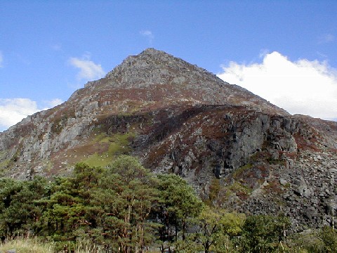 Pen yr Ole Wen |
| Y Garn‡ | 947 | 236 | SH630595 | Marilyn | Glyder Fawr | |
| Foel-fras | 944 | 61 | SH696681 | Hewitt | Carnedd Llewelyn | |
| Garnedd Uchaf | 926 | 32 | SH687669 | Hewitt | Carnedd Llewelyn | |
| Elidir Fawr‡ | 924 | 212 | SH612613 | Marilyn | Y Garn |  Tryfan |
| Crib Goch | 923 | 65 | SH624551 | Hewitt | Snowdon | |
| Tryfan‡ | 918 | 191 | SH664593 | Marilyn | Glyder Fawr | |
(‡) Have the prominence of over 150 metres (492 ft) to qualify as a Real Monro (these are Marilyns, and/or P600s)
Irish Munros
There are 13 Furths in Ireland listed by the Scottish Mountaineering Club, which are also referred to as the Irish Munros.
| Peak | Height (m) |
Prominence (m) |
OSI Grid Reference |
Highest Class[lower-alpha 4] |
Parent Peak[lower-alpha 6] |
|
|---|---|---|---|---|---|---|
| Carrauntoohil‡ | 1039 | 1039 | V8036584426 | P600 | n.a. | 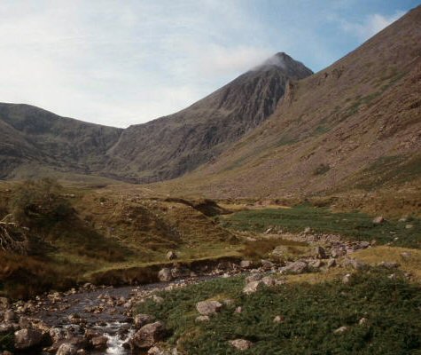 Carrauntoohil |
| Beenkeragh | 1008 | 91 | V8013985245 | Hewitt | Carrauntoohil | |
| Caher | 1000 | 100 | V7926183891 | Hewitt | Carrauntoohil | 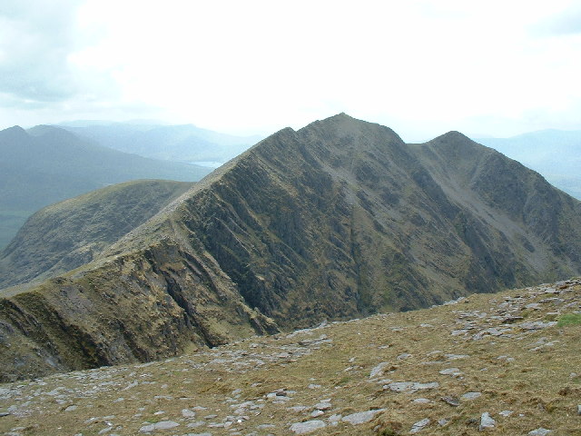 Caher |
| Cnoc na Péiste‡ | 988 | 254 | V8359084176 | Marilyn | Carrauntoohil | |
| Caher West Top[lower-alpha 5] | 973 | 24 | V7899084004 | Caher |  Maolán Bui (centre: 4th from left) | |
| Maolán Bui | 973 | 41 | V8321483814 | Hewitt | Cnoc na Péiste | |
| Cnoc an Chuillin | 958 | 54 | V8234683338 | Hewitt | Maolán Bui |  The Bones (centre) |
| The Bones | 956 | 37 | V8007084680 | Hewitt | Carrauntoohil | |
| Brandon Mountain‡ | 952 | 927 | Q4604511610 | P600 | Cnoc na Péiste |  Brandon Mountain |
| The Big Gun | 939 | 70 | V8400084500 est. | Hewitt | Cnoc na Péiste | |
| Cruach Mhór | 932 | 32 | V8400084800 est. | Hewitt | The Big Gun |  Lugnaquilla |
| Lugnaquilla‡ | 925 | 849 | T0320091700 est. | P600 | Cruach Mhór | |
| Galtymore‡ | 919 | 899 | R8784623788 | P600 | Cruach Mhór |
(‡) Have the prominence of over 150 metres (492 ft) to qualify as a Real Munro (these are Marilyns, and/or P600s)
DoBIH codes
The DoBIH uses the following codes for the various classifications of mountains and hills in the British Isles, which many of the above peaks also fall into:[15][16]
- Ma Marilyn
- Hu HuMP
- Sim Simm
- 5 Dodd
- M Munro
- MT Munro Top
- F Furth
- C Corbett
- G Graham
- D Donald
- DT Donald Top
- Hew Hewitt
- N Nuttall
- Dew Dewey
- DDew Donald Dewey
- HF Highland Five
- 4 400-499m Tump
- 3 300-399m Tump (GB)
- 2 200-299m Tump (GB)
- 1 100-199m Tump (GB)
- 0 0-99m Tump (GB)
- W Wainwright
- WO Wainwright Outlying Fell
- B Birkett
- Sy Synge
- Fel Fellranger
- CoH County Top – Historic (pre-1974)
- CoA County Top – Administrative (1974 to mid-1990s)
- CoU County Top – Current County or Unitary Authority
- CoL County Top – Current London Borough
- SIB Significant Island of Britain
- Dil Dillon
- A Arderin
- VL Vandeleur-Lynam
- MDew Myrddyn Dewey
- O Other list (which includes):
- Bin Binnion
- Bg Bridge
- BL Buxton & Lewis
- Ca Carn
- CT Corbett Top
- GT Graham Top
- Mur Murdo
- P500 P500
- P600 P600
- Un unclassified
- s sub
- x deleted
suffixes:
= twin
See also
- List of mountains of the British Isles by height
- List of mountains of the British Isles by prominence
- Lists of mountains and hills in the British Isles
- Lists of mountains in Ireland
- List of Munro mountains in Scotland
- List of Murdos (mountains)
- List of Marilyns in the British Isles
- List of P600 mountains in the British Isles
Note
- 33 of the 34 SMC Furths have a prominence above 30 metres (98 feet), however, Caher West Top in Ireland, has a prominence of 24 metres (79 feet).
- A derivation of the Himalayan Eight-thousander
- The Database of British and Irish Hills ("DoBIH") is the most referenced database for the classification of peaks in the British Isles,[12] and the DoBIH is licensed under a "Creative Commons Attribution 3.0 Unported License".[13]
- Because all Furths are over 3,000 feet (914.4 m), and therefore meet all the elevation thresholds of Hewitts and Nuttals/Vandeleur-Lynams (P600s and Marilyns do not have elevation thresholds), the only difference is on prominence. 10 have the prominence to be[clarification needed] therefore, the colouring given to a Furth in the tables, is based on the highest definition of prominence that the Furth achieved.
- Nuttalls refers to mountains in England and Wales, the Irish equivalent of Nuttalls is the Vandeleur-Lynam list
- Parent peak is a term used in topographic prominence which can produce results that seem unusual, but are based on the specific guidelines used by the OSI in estimating prominence, and the hierarchy of prominence.
References
- The Furth at www.munromagic.com. Accessed on 4 Feb 2013.
- Some Mountains, Hills and Summits of Great Britain at www.jbutler.org.uk. Accessed on 4 Feb 2013.
- The Munros at where2walk.co.uk. Accessed on 4 Feb 2013.
- "Ireland's Munros". Ireland's Own. 26 June 2018.
- The Furths at www.hill-bagging.co.uk. Accessed on 20 Mar 2013.
- "Magnificent munros: 17 Scottish mountains to bag in your lifetime". The Telegraph. 13 April 2017.
Of the 282, 200 are said to have a summit prominence of over 150 metres and are therefore known as "real monros", but that's for another day.
- "Hill Lists: Furths". Scottish Mountaineering Club.
The list of peaks of 3000ft or more within the United Kingdom and the Republic of Ireland outside (furth) of Scotland. There are currently 34 Furths.
- "Hill Lists: Munros". Scottish Mountaineering Club.
The current list contains 282 peaks. The SMC maintains the list of Munros. In recent times the list has only been altered to reflect updates to nationally recognised topographic data (i.e. data recognised and adopted by the Ordnance Survey). We record all such changes as hill news.
- Clerk of the List (October 2018). "Compleators". Scottish Mountaineering Club.
The SMC hold a record of Munros, Corbetts, Grahams and Donalds compleators.
- Simon Glover (June 2018). "FURTHS AND FURTHISTS". FurthSummits.
- Wakely, Tim (28 November 2016). "Images from a Warming Planet: Interview with Ashley Cooper". Destinations Magazine. Retrieved 12 January 2019.
- Jackson, Mark. "More Relative Hills of Britain" (PDF). Relative Hills of Britain. Archived from the original (PDF) on 12 October 2013. Retrieved 9 September 2011.
- "Copyright". Database of British and Irish Hills. 3 August 2018.
We place no restrictions on use of the data by third parties and encourage authors of other websites and applications to do so. We just ask users to observe the terms of the Creative Commons license
- "Background to the lists". Database of British and Irish Hills. 2 August 2018.
- "Classification". Database of British and Irish Hills. 3 August 2018.
- "Welcome to the online version of the Database of British and Irish Hills (DoBIH)". HillBagging. Retrieved 8 November 2018.
External links
| British Isles |  | |
|---|---|---|
| Scotland | ||
| Outside Scotland | ||
| England | ||
| Ireland | ||
| County tops |
| |
Другой контент может иметь иную лицензию. Перед использованием материалов сайта WikiSort.org внимательно изучите правила лицензирования конкретных элементов наполнения сайта.
WikiSort.org - проект по пересортировке и дополнению контента Википедии