geo.wikisort.org - Mountains
Bengower (Irish: Binn Gabhar, meaning 'Goats' Peak')[2] at 664 metres (2,178 ft), is the 135th–highest peak in Ireland on the Arderin scale,[3] and the 166th–highest peak on the Vandeleur-Lynam scale.[4][5] Bengower is in the southern end of the Twelve Bens mountain range in the Connemara National Park in Galway, Ireland, and is the 6th-tallest of the core Twelve Bens.[5][6]
| Bengower | |
|---|---|
| Binn Gabhar | |
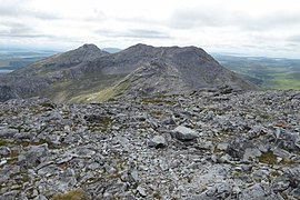
 Summit of Bengower viewed from Benbreen | |
| Highest point | |
| Elevation | 664 m (2,178 ft)[1] |
| Prominence | 196 m (643 ft)[1] |
| Listing | 100 Highest Irish Mountains, Marilyn, Hewitt, Arderin, Simm, Vandeleur-Lynam |
| Coordinates | 53°29′31″N 9°50′02″W[1] |
| Naming | |
| English translation | Goats' Peak |
| Language of name | Irish |
| Geography | |
 Bengower Ireland | |
| Location | Galway, Ireland |
| Parent range | Twelve Bens |
| OSI/OSNI grid | L7830150644 |
| Topo map | OSi Discovery 37 |
| Geology | |
| Type of rock | Pale quartzites, grits, graphitic bedrock[1] |
Naming
Irish academic Paul Tempan notes that there is no evidence as to the origin of the "goat" reference, however, he notes that the mountain was mistakenly labelled as "Glengower" in the popular Discovery Map series.[2]
Geography
Bengower lies between the summits of Benbreen 691 metres (2,267 ft), to the north, and Benlettery 577 metres (1,893 ft), and Benglenisky 517 metres (1,696 ft), to the south.[5] Climbing guidebooks note that its northerly rocky ridge (that rises up from the col of Irish: Mám na Gaoithe, or "pass of the wind" at 470 metres) requires scrambling to reach the summit.[7][8][9]
Bengower’s prominence of 196 metres (643 ft) qualifies it as a Marilyn, and it also ranks it as the 86th-highest mountain in Ireland in the MountainViews Online Database, 100 Highest Irish Mountains, where the prominence threshold is 100 metres.[5][10]
Hill walking
Because of its positioning, the more straightforward routes to climb Bengower usually follow a 7-kilometre 3-4 hour horseshoe loop-walk with the neighbouring peaks of Benlettery and Benglenisky.[11][12][13]
Bengower is often climbed as part of the popular 16–kilometre 8–9 hour Glencoaghan Horseshoe, considered one of Ireland's best hill-walks.[7][8][9] Bengower is also climbed as part of the longer Owenglin Horseshoe, a 20–kilometre 10–12 hour route around the Owenglin River taking in over twelve summits.[14][15]
Gallery


 Bengower (back left) behind Benbreen, viewed from Bencollaghduff
 Benlettery (left) and Benglenisky (right) from the summit of Bengower


Bibliography
- Fairbairn, Helen (2014). Ireland's Best Walks: A Walking Guide. Collins Press. ISBN 978-1848892118.
- MountainViews Online Database (Simon Stewart) (2013). A Guide to Ireland's Mountain Summits: The Vandeleur-Lynams & the Arderins. Collins Books. ISBN 978-1-84889-164-7.
- Paul Phelan (2011). Connemara & Mayo - A Walking Guide: Mountain, Coastal & Island Walks. Collins Press. ISBN 978-1848891029.
- Dillion, Paddy (2001). Connemara: Collins Rambler's guide. Harper Collins. ISBN 978-0002201216.
- Dillion, Paddy (1993). The Mountains of Ireland: A Guide to Walking the Summits. Cicerone. ISBN 978-1852841102.
See also
| Wikimedia Commons has media related to Bengower. |
- Twelve Bens
- Mweelrea, major range in Killary Harbour
- Maumturks, major range in Connemara
- Lists of mountains in Ireland
- Lists of mountains and hills in the British Isles
- List of Marilyns in the British Isles
- List of Hewitt mountains in England, Wales and Ireland
References
- "Bengower". MountainViews Online Database. Retrieved 31 July 2019.
- Paul Tempan (February 2012). "Irish Hill and Mountain Names" (PDF). MountainViews.ie.
- Simon Stewart (October 2018). "Arderins: Irish mountains of 500+m with a prominence of 30m". MountainViews Online Database.
- Simon Stewart (October 2018). "Vandeleur-Lynams: Irish mountains of 600+m with a prominence of 15m". MountainViews Online Database.
- Mountainviews, (September 2013), "A Guide to Ireland's Mountain Summits: The Vandeleur-Lynams & the Arderins", Collins Books, Cork, ISBN 978-1-84889-164-7
- Dillion, Paddy (2001). Connemara: Collins Rambler's guide. Harper Collins. ISBN 978-0002201216.
- Helen Fairbairn (30 December 2014). Ireland's Best Walks: A Walking Guide (Walking Guides). Collins Press. ISBN 978-1848892118.
ROUTE 34: The Glencoaghan Horseshoe. A true classic
- Tony Doherty (22 June 2016). "A walk for the weekend: The Twelve Bens of Connemara are a hard walk but worth it". Irish Times.
Even if you had to crawl across bogs to get to them, it would be worth it as the nine peaks which form the Glencoaghan Horseshoe provide some of the most exhilarating mountaineering on this island.
- Dillion, Paddy (2001). Connemara: Collins Rambler's guide. Harper Collins. ISBN 978-0002201216.
Walk 30: Gleann Chóchan Horseshoe
- "Irish Highest 100: The highest 100 Irish mountains with a prominence of +100m". MountainViews Online Database. September 2018.
- Dillion, Paddy (2001). Connemara: Collins Rambler's guide. Harper Collins. ISBN 978-0002201216.
Walk 23: Binn Ghleann Uisce
- John G. O'Dwyer (29 October 2015). "A walk for the weekend: Twelve Bens, Connemara, Co Galway". Irish Times. Retrieved 9 August 2019.
- Paul Phelan (2011). Connemara & Mayo - A Walking Guide: Mountain, Coastal & Island Walks. Collins Press. ISBN 978-1848891029.
Route 4: Benglenisky, Bengower and Benlettery
- "Owenglin Horseshoe". MountainViews Online Database. Retrieved 30 July 2019.
- Dillion, Paddy (2001). Connemara: Collins Rambler's guide. Harper Collins. ISBN 978-0002201216.
Walk 24: Owenglin Horseshoe
External links
- MountainViews: The Irish Mountain Website, Bengower
- MountainViews: Irish Online Mountain Database
- The Database of British and Irish Hills , the largest database of British Isles mountains ("DoBIH")
- Hill Bagging UK & Ireland, the searchable interface for the DoBIH
| British Isles |  | |
|---|---|---|
| Scotland | ||
| Outside Scotland | ||
| England | ||
| Ireland | ||
| County tops |
| |
Mountains and hills of Connacht | |||||||
|---|---|---|---|---|---|---|---|
List of mountains in Ireland | |||||||
| Achill Island |  | ||||||
| Curlew Mountains | |||||||
| Dartry Mountains | |||||||
| Maumturks | |||||||
| Mweelrea Mountains |
| ||||||
| Nephin Range | |||||||
| Ox Mountains | |||||||
| Partry Mountains | |||||||
| Sheeffry Range | |||||||
| Twelve Bens |
| ||||||
| Others | |||||||
Lists of long-distance trails in Ireland | ||||||
|---|---|---|---|---|---|---|
| Long-Distance |
|   | ||||
| Pilgrim path |
| |||||
| Cycle greenway |
| |||||
| Boarded mountain | ||||||
| Fell running | ||||||
Другой контент может иметь иную лицензию. Перед использованием материалов сайта WikiSort.org внимательно изучите правила лицензирования конкретных элементов наполнения сайта.
WikiSort.org - проект по пересортировке и дополнению контента Википедии